File:Panama Canal Map ES.png
Jump to navigation
Jump to search

Size of this preview: 581 × 600 pixels. Other resolutions: 232 × 240 pixels | 465 × 480 pixels | 744 × 768 pixels | 992 × 1,024 pixels | 2,191 × 2,262 pixels.
Original file (2,191 × 2,262 pixels, file size: 3.47 MB, MIME type: image/png)
Captions
Captions
Add a one-line explanation of what this file represents
Summary[edit]
| Description |
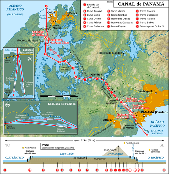
English: Map of the Panama Canal (Spanish version) |
| Date | |
| Source |
Own work Map created using: |
| Author | Thoroe |
| Permission (Reusing this file) |
Map data (c) OpenStreetMap (and) contributors, CC-BY-SA |
| Other versions |
[]
|


|
This map has been made or improved in the German Kartenwerkstatt (Map Lab). You can propose maps to improve as well.
|
Licensing[edit]
This file is licensed under the Creative Commons Attribution-Share Alike 2.0 Generic license.
Attribution: Thomas Römer/OpenStreetMap data
- You are free:
- to share – to copy, distribute and transmit the work
- to remix – to adapt the work
- Under the following conditions:
- attribution – You must give appropriate credit, provide a link to the license, and indicate if changes were made. You may do so in any reasonable manner, but not in any way that suggests the licensor endorses you or your use.
- share alike – If you remix, transform, or build upon the material, you must distribute your contributions under the same or compatible license as the original.
File history
Click on a date/time to view the file as it appeared at that time.
| Date/Time | Thumbnail | Dimensions | User | Comment | |
|---|---|---|---|---|---|
| current | 15:51, 3 October 2021 | | 2,191 × 2,262 (3.47 MB) | Thoroe (talk | contribs) | + Puente Atlántico |
| 23:05, 15 February 2017 |  | 2,191 × 2,262 (3.6 MB) | Thoroe (talk | contribs) | Update | |
| 13:11, 6 July 2014 |  | 1,294 × 1,336 (1.67 MB) | Thoroe (talk | contribs) | Small text fixes | |
| 16:43, 15 June 2013 |  | 2,586 × 2,670 (3.7 MB) | Thoroe (talk | contribs) | {{Information |Description ={{en|1=Map of the Panama Canal (Spanish version)}} |Source ={{own}} Map created using: *[http://gmt.soest.hawaii.edu Generic Mapping Tools (GMT)] with [http://www2.jpl.nasa.gov/srtm/ SRTM3 V2... |
You cannot overwrite this file.
File usage on Commons
The following 13 pages use this file:
- User:Chumwa/OgreBot/Potential transport maps/2017 February 10-18
- User:Chumwa/OgreBot/Transport Maps/2017 February 10-18
- User:Chumwa/OgreBot/Transport Maps/2021 October 1-10
- User:Chumwa/OgreBot/Travel and communication maps/2017 February 10-18
- User:Magog the Ogre/Multilingual legend/2021 October 1-10
- File:Panama Canal Map-ru.svg
- File:Panama Canal Map-zh cn.svg
- File:Panama Canal Map DE.png
- File:Panama Canal Map EN.png
- File:Panama Canal Map EN.svg
- File:Panama Canal Map ES.png
- File:Panama Canal Map FR.png
- Template:Other versions/Panama Canal Map
File usage on other wikis
The following other wikis use this file:
- Usage on ca.wikipedia.org
- Usage on de.wikipedia.org
- Usage on es.wikipedia.org