File:Paklinska ostrva-sr.svg
Jump to navigation
Jump to search

Size of this PNG preview of this SVG file: 800 × 334 pixels. Other resolutions: 320 × 134 pixels | 640 × 267 pixels | 1,024 × 428 pixels | 1,280 × 534 pixels | 2,560 × 1,069 pixels | 1,121 × 468 pixels.
Original file (SVG file, nominally 1,121 × 468 pixels, file size: 83 KB)
Captions
Captions
Add a one-line explanation of what this file represents
Summary[edit]
| Description |
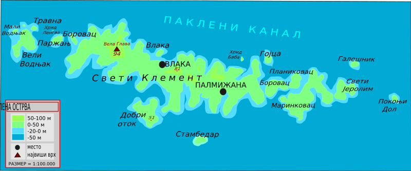
English: Topographic map of Paklinska islands near Hvar, Croatia
Hrvatski: Topografska mapa Paklinski otoka kod Hvara
Српски / srpski: Топографска карта Паклинских острва у близини Хвара |
| Date | |
| Source | MK-19 O. Hvar Nautička karta |
| Author | Ivan25 |
Licensing[edit]
I, the copyright holder of this work, hereby publish it under the following licenses:

|
Permission is granted to copy, distribute and/or modify this document under the terms of the GNU Free Documentation License, Version 1.2 or any later version published by the Free Software Foundation; with no Invariant Sections, no Front-Cover Texts, and no Back-Cover Texts. A copy of the license is included in the section entitled GNU Free Documentation License. |
This file is licensed under the Creative Commons Attribution 3.0 Unported license.
- You are free:
- to share – to copy, distribute and transmit the work
- to remix – to adapt the work
- Under the following conditions:
- attribution – You must give appropriate credit, provide a link to the license, and indicate if changes were made. You may do so in any reasonable manner, but not in any way that suggests the licensor endorses you or your use.
You may select the license of your choice.
File history
Click on a date/time to view the file as it appeared at that time.
| Date/Time | Thumbnail | Dimensions | User | Comment | |
|---|---|---|---|---|---|
| current | 11:56, 22 November 2009 | | 1,121 × 468 (83 KB) | Ivan25 (talk | contribs) | Relief and legend added. |
| 11:19, 20 November 2009 |  | 1,121 × 468 (68 KB) | Ivan25 (talk | contribs) | {{Information |Description={{en|1=Topographic map of Paklinska islands near Hvar, Croatia}} {{hr|1=Topografska mapa Paklinski otoka kod Hvara}} {{sr|1=Топографска карта Паклинских острва у близини Хвара}} |Sour |
You cannot overwrite this file.
File usage on Commons
The following page uses this file:
File usage on other wikis
The following other wikis use this file:
- Usage on sh.wikipedia.org
- Usage on sr.wikipedia.org