File:Pacific Northwest (MODIS 2018-07-28).jpg

Original file (2,288 × 1,659 pixels, file size: 490 KB, MIME type: image/jpeg)
Captions
Captions
Summary[edit]
.jpg&action=edit§ion=1)
| Description |
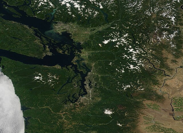
English: On July 22, 2018, the Moderate Resolution Imaging Spectroradiometer (MODIS) aboard NASA’s Terra satellite flew over the Pacific Northwest, allowing the Moderate Resolution Imaging Spectroradiometer (MODIS) on board to acquire a true-color image of the scene.
The most notable feature is a broad swath of gray pixels on the eastern shores of the Strait of Georgia. In true-color images human activity, such as buildings and roadways, appear gray. In this case, the metropolitan area of Vancouver, Canada sits in the northernmost area of gray while, in the southernmost section of the swath sits the city of Bellingham, Washington. The boundary between Canada loops south to include the large, oval-shaped Vancouver Island in the far west, then arcs northwestward around Orcas Island, which belongs to Washington state in the United States. A broad bank of low cloud (fog) hugs the coast of Washington. A long plume of sediment streams across the Strait of Georgia from the Fraser River. The Fraser is the longer river in British Columbia, winding for nearly 870 miles (1,400 km). Fed by snowmelt, the river picks up about 20 million tons of silt each year, most of which pours into the Strait of Georgia. The silty plume, which is easily seen from space, also marks freshwater inflow into the saline Strait. |
||
| Date | Taken on 22 July 2018 | ||
| Source |
Pacific Northwest (direct link)
|
||
| Author | Jeff Schmaltz, MODIS Land Rapid Response Team, NASA GSFC |
| This media is a product of the Terra mission Credit and attribution belongs to the mission team, if not already specified in the "author" row |
Licensing[edit]
.jpg&action=edit§ion=2)
| This file is in the public domain in the United States because it was solely created by NASA. NASA copyright policy states that "NASA material is not protected by copyright unless noted". (See Template:PD-USGov, NASA copyright policy page or JPL Image Use Policy.) | ||
 |
Warnings:
|
File history
Click on a date/time to view the file as it appeared at that time.
| Date/Time | Thumbnail | Dimensions | User | Comment | |
|---|---|---|---|---|---|
| current | 01:36, 17 February 2024 | | 2,288 × 1,659 (490 KB) | OptimusPrimeBot (talk | contribs) | #Spacemedia - Upload of http://modis.gsfc.nasa.gov/gallery/images/image07282018_250m.jpg via Commons:Spacemedia |
You cannot overwrite this file.
File usage on Commons
There are no pages that use this file.
.jpg&oldid=852774248)