File:PIA21135 Schiaparelli Impact Site on Mars, Stereo.jpg
Original file (763 × 968 pixels, file size: 69 KB, MIME type: image/jpeg)
Captions
Captions
Summary[edit]
| Description |
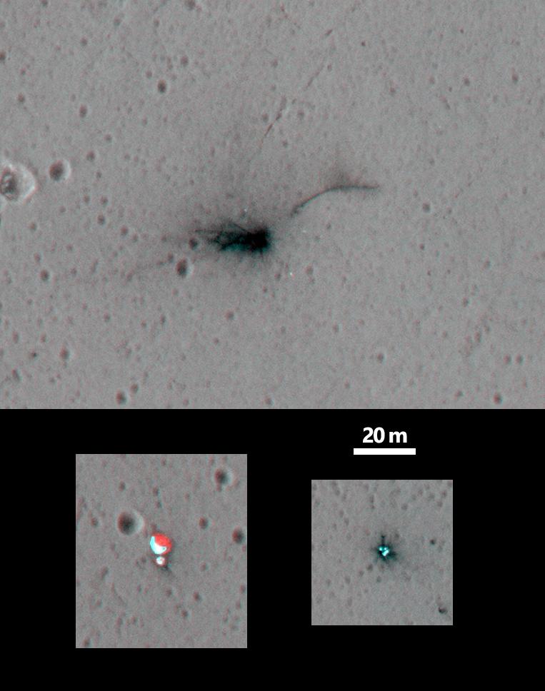
English: These three views of locations where hardware from the European Space Agency's Schiaparelli test lander reached the surface of Mars on Oct. 19, 2016, combine two orbital views from different angles as a stereo pair. The view was created to appear three-dimensional when seen through red-blue glasses with the red lens on the left, though the scene is too flat to show much relief.
The stereo preparation uses images taken on Oct. 25, 2016, [PIA21131] and Nov. 1, 2016, [PIA21132] by the High Resolution Imaging Science Experiment (HiRISE) camera on NASA's Mars Reconnaissance Orbiter. The left-eye (red-tinted) component of the stereo is from the earlier observation, which was taken from farther west than the second observation. These views shows three sites where parts of the Schiaparelli spacecraft hit the ground: the lander module itself in the upper portion, the parachute and back shell at lower left, and the heat shield at lower right. The parachute's shape on the ground changed between the two observation dates, cancelling the three-dimensional effect of having views from different angles. The scale bar of 20 meters (65.6 feet) applies to all three portions. Schiaparelli was one component of the European Space Agency's ExoMars 2016 project, which placed the Trace Gas Orbiter into orbit around Mars on the same arrival date. The ExoMars project received data from Schiaparelli during its descent through the atmosphere. ESA has reported that the heat shield separated as planned, the parachute deployed as planned but was released (with back shell) prematurely, and the lander hit the ground at a velocity of more than 180 miles per hour (more than 300 kilometers per hour). The University of Arizona, Tucson, operates HiRISE, which was built by Ball Aerospace & Technologies Corp., Boulder, Colo. NASA's Jet Propulsion Laboratory, a division of Caltech in Pasadena, California, manages the Mars Reconnaissance Orbiter Project for NASA's Science Mission Directorate, Washington. |
| Date | (published 15 November 2016) |
| Source | Catalog page · Full-res (JPEG · TIFF) |
| Author | NASA/JPL-Caltech/Univ. of Arizona |
| Location on Mars | View this and other nearby images on: Google Maps |
|---|
This image or video was catalogued by Jet Propulsion Laboratory of the United States National Aeronautics and Space Administration (NASA) under Photo ID: PIA21135. This tag does not indicate the copyright status of the attached work. A normal copyright tag is still required. See Commons:Licensing. Other languages:
|
 |
This media is a product of the Mars Reconnaissance Orbiter mission Credit and attribution belongs to the High Resolution Imaging Science Experiment (HiRISE) team, NASA/JPL-Caltech/Univ. of Arizona |
 |
This file is a stereogram. Stereograms are stereoscopic images or animations which combine left and right frames showing slightly different visual angles to allow for 3D perception.
3D red-cyan glasses are recommended to view this image correctly. |
|---|
Licensing[edit]
| This file is in the public domain in the United States because it was solely created by NASA. NASA copyright policy states that "NASA material is not protected by copyright unless noted". (See Template:PD-USGov, NASA copyright policy page or JPL Image Use Policy.) | ||
 |
Warnings:
|
File history
Click on a date/time to view the file as it appeared at that time.
| Date/Time | Thumbnail | Dimensions | User | Comment | |
|---|---|---|---|---|---|
| current | 02:10, 4 March 2017 | | 763 × 968 (69 KB) | PhilipTerryGraham (talk | contribs) | User created page with UploadWizard |
You cannot overwrite this file.
File usage on Commons
The following 2 pages use this file: