File:PENNSYLVANIA AVENUE SE FROM THE CAPITOL DOME.jpg

Original file (968 × 677 pixels, file size: 463 KB, MIME type: image/jpeg)
Captions
Captions
Summary[edit]
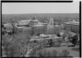
| English: SOUTHEAST ON PENNSYLVANIA AVENUE FROM THE CAPITOL DOME.
( |
||||||||||||||||||||||||
|---|---|---|---|---|---|---|---|---|---|---|---|---|---|---|---|---|---|---|---|---|---|---|---|---|
| Photographer |
unknown creator |
|||||||||||||||||||||||
| Title |
English: SOUTHEAST ON PENNSYLVANIA AVENUE FROM THE CAPITOL DOME. |
|||||||||||||||||||||||
| Description |
English: 13. VIEW SOUTHEAST ON PENNSYLVANIA AVENUE FROM THE CAPITOL DOME. - Pennsylvania Avenue, Washington, District of Columbia, DC |
|||||||||||||||||||||||
| Dimensions | 5 x 7 in. | |||||||||||||||||||||||
| Collection |
|
|||||||||||||||||||||||
| Accession number |
HABS DC,WASH,627--13 |
|||||||||||||||||||||||
| Source |
|
|||||||||||||||||||||||
| Permission (Reusing this file) |
Rights Advisory: No known restrictions on publication. | |||||||||||||||||||||||
| Other versions |
|
|||||||||||||||||||||||


| Camera location | | View this and other nearby images on: OpenStreetMap |
|---|
| This image is a JPEG version of the original TIF image at File: Pennsylvania avenue se from the capitol dome.tif.
This JPEG version should be used when displaying the file from Commons, as the MediaWiki software is unable to create a thumbnail or preview of the original TIF file, because it is larger than 1000 megapixels. However, any edits to the image should be based on the original TIF version in order to prevent generation loss, and both versions should be updated. Do not make edits based on this version. |
Licensing[edit]

|
This file comes from the Historic American Buildings Survey (HABS), Historic American Engineering Record (HAER) or Historic American Landscapes Survey (HALS). These are programs of the National Park Service established for the purpose of documenting historic places. Records consist of measured drawings, archival photographs, and written reports.
|
| This image or media file contains material based on a work of a National Park Service employee, created as part of that person's official duties. As a work of the U.S. federal government, such work is in the public domain in the United States. See the NPS website and NPS copyright policy for more information. |
File history
Click on a date/time to view the file as it appeared at that time.
| Date/Time | Thumbnail | Dimensions | User | Comment | |
|---|---|---|---|---|---|
| current | 15:40, 16 July 2013 | | 968 × 677 (463 KB) | Slowking4 (talk | contribs) |
You cannot overwrite this file.
File usage on Commons
The following 3 pages use this file: