File:Ordnance Survey Drawings - Rainham (OSD 115).jpg
Jump to navigation
Jump to search

Size of this preview: 800 × 535 pixels. Other resolutions: 320 × 214 pixels | 640 × 428 pixels | 1,024 × 684 pixels | 1,280 × 855 pixels | 2,560 × 1,711 pixels | 4,000 × 2,673 pixels.
Original file (4,000 × 2,673 pixels, file size: 2.94 MB, MIME type: image/jpeg)
Captions
Captions
Add a one-line explanation of what this file represents
Summary[edit]
| Rainham (Kent) (OSD 115)
|
|||
|---|---|---|---|
| Title |
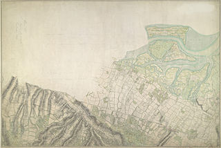
Ordnance Survey Drawings: Rainham (OSD 115) |
.jpg) | |
| Object type |
manuscript map |
||
| Description |
 Centre of map shown on a map of England
English: This map of the Rainham Marshes in Kent is drawn on rectangular sheet lines, enclosed by a black border. Fields are coloured brown where cultivated, and green or blank if untilled. Stonework buildings or structures are drawn in red ink at the major settlement of Rainham, at the bottom right of the plan. Infilled or blocked areas of black or sepia ink indicate structures or buildings made from impermanent materials such as wood. Corrections have been made on this plan and the altitudes from sites of eminenece ('spot heights') are noted in red ink figures. Field boundaries are measured rather than estimated or sketched..
This image has been georeferenced.
|
||
| Language |
English |
||
| Date | 1797 | ||
| Medium | Pen and ink on paper | ||
| Dimensions | height: 300 mm (11.81 in); width: 430 mm (16.92 in) | ||
| Collection | |||
| Accession number |
Maps OSD 115 |
||
| Credit line | British Library | ||
| Notes |
Scale 6 inches : 1 mile (1:10560). Please note that the British Library provides these digital files "as-is"; materials will not be rephotographed under this programme. If resupply of files is required, the requestor will be required to purchase them at the standard rate. |
||
| References |
http://www.bl.uk/onlinegallery/onlineex/ordsurvdraw/r/002osd00000027bu00438000.html (English) |
||
| Source/Photographer |
|
||


.jpg&action=edit§ion=1)
.jpg¶ms=51.387302_N_0.567545_E_)
.jpg¶ms=51.353632_N_0.488844_E_)
.jpg¶ms=51.420973_N_0.646245_E_)
.jpg¶ms=51.419858_N_0.488844_E_)
.jpg¶ms=51.353632_N_0.48945_E_)
.jpg¶ms=51.354747_N_0.646245_E_)
.jpg¶ms=51.420973_N_0.645639_E_)
Licensing[edit]
.jpg&action=edit§ion=2)
_(St_Edwards_Crown).svg)
|
This file is licensed under the Open Government Licence version 1.0 (OGL v1.0).
|
|---|---|
|
You are free to:
See the Open Government Licence page on Meta-Wiki for more information.
|
File history
Click on a date/time to view the file as it appeared at that time.
| Date/Time | Thumbnail | Dimensions | User | Comment | |
|---|---|---|---|---|---|
| current | 22:44, 25 September 2013 | | 4,000 × 2,673 (2.94 MB) | LibraryBot (talk | contribs) | {{subst:User:Andrew Gray/OSD|ID= 002OSD00000027BU00438000 |OSD_NUM= OSD 115 |MEDIUM= Pen and ink on paper |TITLE= Rainham |CREATOR= |YEAR= 1797 |DESCRIPTION= This map of the Rainham Marshes in Kent is drawn on rectangular sheet lines, enclosed by a b... |
You cannot overwrite this file.
File usage on Commons
The following page uses this file:
File usage on other wikis
The following other wikis use this file:
- Usage on www.wikidata.org
.jpg&oldid=838007855)