File:Ordnance Survey Drawings - Hereford, Herefordshire (OSD 204).jpg
Jump to navigation
Jump to search
Size of this preview: 800 × 480 pixels. Other resolutions: 320 × 192 pixels | 1,024 × 614 pixels | 1,280 × 767 pixels | 2,560 × 1,535 pixels | 5,757 × 3,451 pixels.
Original file (5,757 × 3,451 pixels, file size: 4.66 MB, MIME type: image/jpeg)
Captions
Captions
Add a one-line explanation of what this file represents
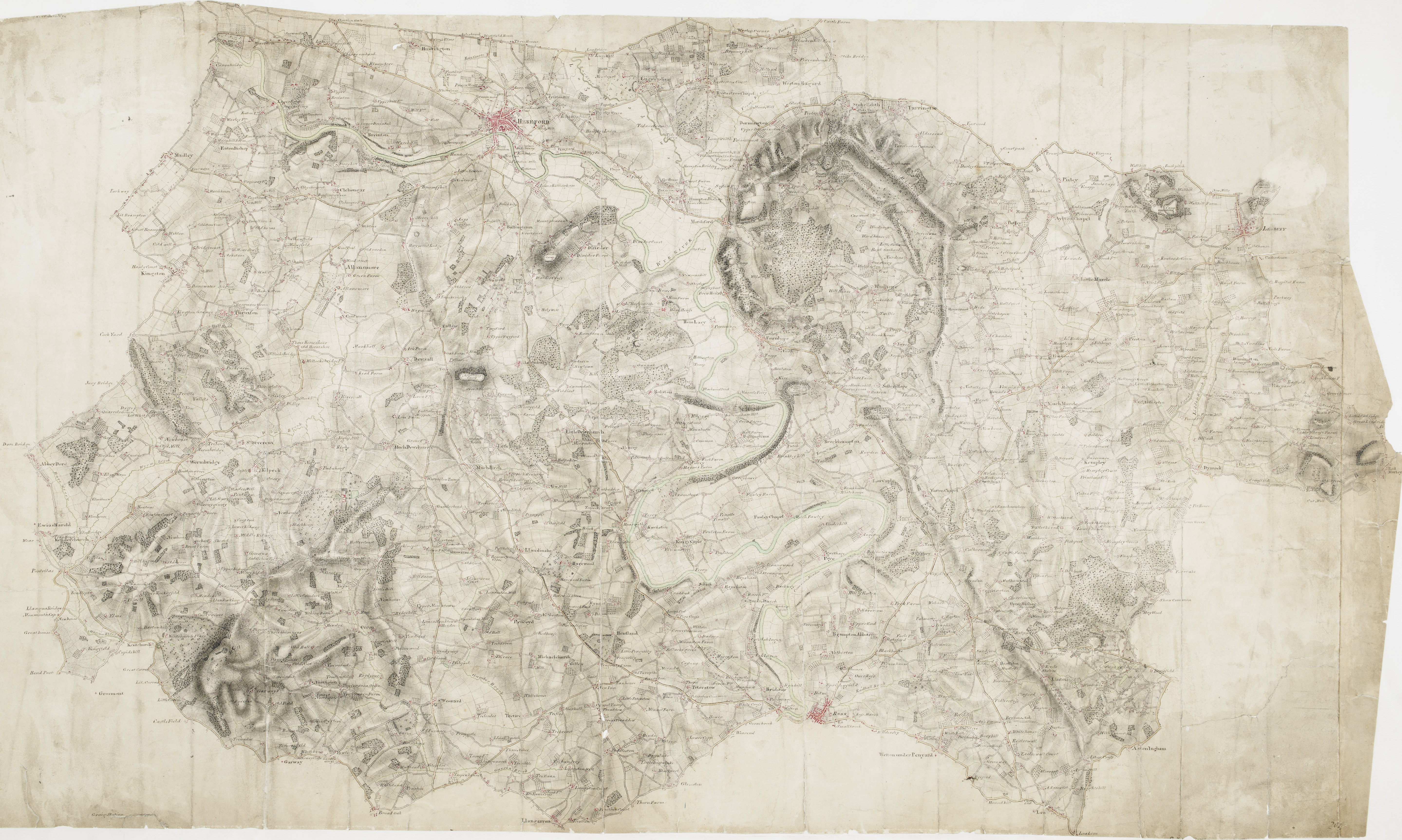
| Hereford 22 (OSD 204)
|
|||||
|---|---|---|---|---|---|
| Artist |
[Budgen, Thomas] - Draughtsman |
.jpg) | |||
| Title |
Ordnance Survey Drawings: Hereford, Herefordshire (OSD 204) |
||||
| Object type |
manuscript map |
||||
| Description |
 Centre of map shown on a map of England
English: Below the city of Hereford, near the top of the sheet, the River Wye flows,through a winding river channel,across a broad floodplain with few major settlements. The floodplain is mostly farmland, dotted by,very small areas of woodland and marsh., The main river banks are lined irregularly with tall alder and willow trees, illustrated on this plan..
This image has been georeferenced.
|
||||
| Language |
English |
||||
| Date | 1815 | ||||
| Medium | Pen and ink on paper | ||||
| Dimensions | height: 300 mm (11.81 in); width: 500 mm (19.68 in) | ||||
| Collection | |||||
| Accession number |
Maps OSD 204 |
||||
| Credit line | British Library | ||||
| Notes |
Scale 2 inches : 1 mile (1:31680). Please note that the British Library provides these digital files "as-is"; materials will not be rephotographed under this programme. If resupply of files is required, the requestor will be required to purchase them at the standard rate. |
||||
| References |
http://www.bl.uk/onlinegallery/onlineex/ordsurvdraw/h/002osd000000022u00163000.html (English) |
||||
| Source/Photographer |
|
||||
| Permission (Reusing this file) |
|
||||


_(St_Edwards_Crown).svg)
.jpg¶ms=51.983187_N_-2.637345_E_)
.jpg¶ms=51.874637_N_-2.917651_E_)
.jpg¶ms=52.091738_N_-2.357039_E_)
.jpg¶ms=52.082863_N_-2.916656_E_)
.jpg¶ms=51.883512_N_-2.358034_E_)
File history
Click on a date/time to view the file as it appeared at that time.
| Date/Time | Thumbnail | Dimensions | User | Comment | |
|---|---|---|---|---|---|
| current | 09:18, 26 September 2013 | | 5,757 × 3,451 (4.66 MB) | LibraryBot (talk | contribs) | {{subst:User:Andrew Gray/OSD|ID= 002OSD000000022U00163000 |OSD_NUM= OSD 204 |MEDIUM= Pen and ink on paper |TITLE= Hereford, Herefordshire |CREATOR= [Budgen, Thomas] - Draughtsman |YEAR= 1815 |DESCRIPTION= Below the city of Hereford, near the top of the... |
You cannot overwrite this file.
File usage on Commons
The following page uses this file:
File usage on other wikis
The following other wikis use this file:
- Usage on www.wikidata.org
.jpg&oldid=757846461)