File:Ordnance Survey Drawings - Halstow Creek (OSD 114).jpg
Jump to navigation
Jump to search
Size of this preview: 800 × 541 pixels. Other resolutions: 320 × 217 pixels | 640 × 433 pixels | 1,024 × 693 pixels | 1,280 × 866 pixels | 2,560 × 1,732 pixels | 4,000 × 2,707 pixels.
Original file (4,000 × 2,707 pixels, file size: 2.94 MB, MIME type: image/jpeg)
Captions
Captions
Add a one-line explanation of what this file represents
| Halstow (Kent) (OSD 114)
|
|||||
|---|---|---|---|---|---|
| Title |
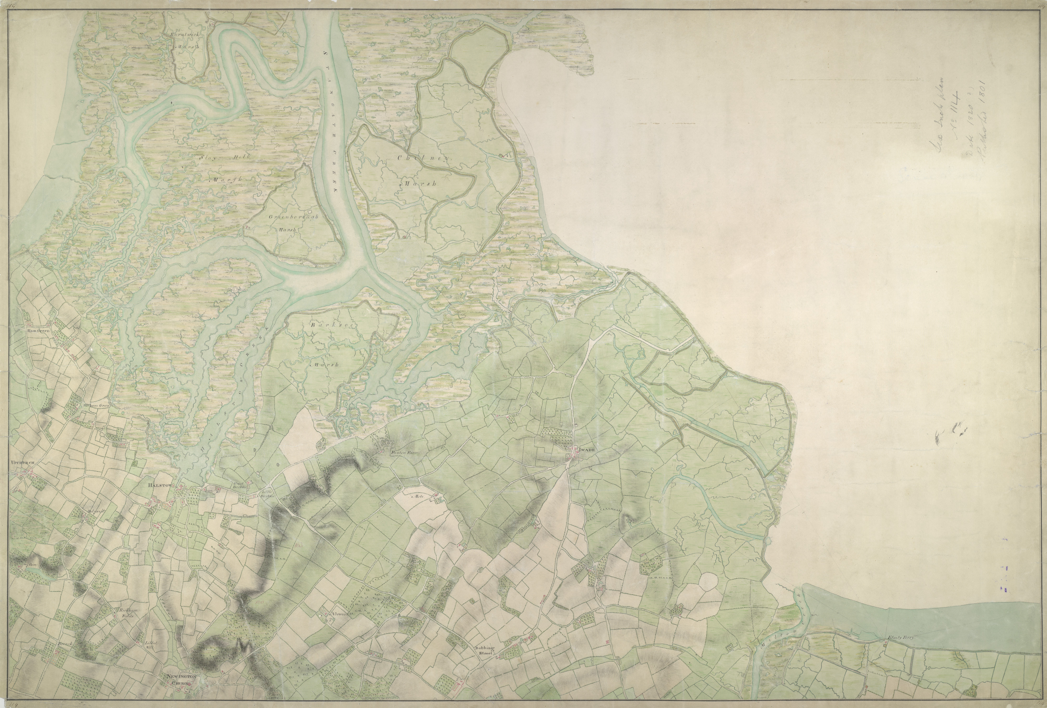
Ordnance Survey Drawings: Halstow Creek (OSD 114) |
.jpg) | |||
| Object type |
manuscript map |
||||
| Description |
 Centre of map shown on a map of England
English: Drawing showing the area around Halstow in Kent. This map is drawn on rectangular sheet lines, enclosed by a black border. Fields are coloured brown where cultivated, and green or blank if untilled. Marshland dominates this estuarine landscape and is depicted by symbols with three vertically inclined strokes above a short horizontal line. Stonework buildings or structures are drawn in red ink at settlements such as Iwade and Halstow at the centre of the plan. Ruled pencil rays intersect the map, evidence of angular measurements taken by the surveyor between fixed triangulation points. Altitudes ('spot heights') are measured and noted in red-ink figures..
This image has been georeferenced.
|
||||
| Language |
English |
||||
| Date | 1797 | ||||
| Medium | Pen and ink on paper | ||||
| Dimensions | height: 300 mm (11.81 in); width: 430 mm (16.92 in) | ||||
| Collection | |||||
| Accession number |
Maps OSD 114 |
||||
| Credit line | British Library | ||||
| Notes |
Scale 6 inches : 1 mile (1:10560). Please note that the British Library provides these digital files "as-is"; materials will not be rephotographed under this programme. If resupply of files is required, the requestor will be required to purchase them at the standard rate. |
||||
| References |
http://www.bl.uk/onlinegallery/onlineex/ordsurvdraw/h/002osd00000027bu00437000.html (English) |
||||
| Source/Photographer |
|
||||
| Permission (Reusing this file) |
|
||||


_(St_Edwards_Crown).svg)
.jpg¶ms=51.388122_N_0.722604_E_)
.jpg¶ms=51.354394_N_0.643411_E_)
.jpg¶ms=51.421849_N_0.801797_E_)
.jpg¶ms=51.421341_N_0.643411_E_)
.jpg¶ms=51.354394_N_0.644572_E_)
.jpg¶ms=51.354903_N_0.801797_E_)
.jpg¶ms=51.421849_N_0.800637_E_)
File history
Click on a date/time to view the file as it appeared at that time.
| Date/Time | Thumbnail | Dimensions | User | Comment | |
|---|---|---|---|---|---|
| current | 22:43, 25 September 2013 | | 4,000 × 2,707 (2.94 MB) | LibraryBot (talk | contribs) | {{subst:User:Andrew Gray/OSD|ID= 002OSD00000027BU00437000 |OSD_NUM= OSD 114 |MEDIUM= Pen and ink on paper |TITLE= Halstow Creek |CREATOR= |YEAR= 1797 |DESCRIPTION= Drawing showing the area around Halstow in Kent. This map is drawn on rectangular sheet... |
You cannot overwrite this file.
File usage on Commons
The following page uses this file:
File usage on other wikis
The following other wikis use this file:
- Usage on www.wikidata.org
.jpg&oldid=838007853)