File:Ordnance Survey Drawings - Builth (OSD 196).jpg
Jump to navigation
Jump to search

Size of this preview: 800 × 470 pixels. Other resolutions: 320 × 188 pixels | 640 × 376 pixels | 1,024 × 601 pixels | 1,280 × 752 pixels | 2,560 × 1,503 pixels | 5,747 × 3,375 pixels.
Original file (5,747 × 3,375 pixels, file size: 5.09 MB, MIME type: image/jpeg)
Captions
Captions
Add a one-line explanation of what this file represents
| Baulit (OSD 196)
|
|||||
|---|---|---|---|---|---|
| Artist |
Budgen, Thomas - Draughtsman |
.jpg) | |||
| Title |
Ordnance Survey Drawings: Builth, Powys (OSD 196) |
||||
| Object type |
manuscript map |
||||
| Description |
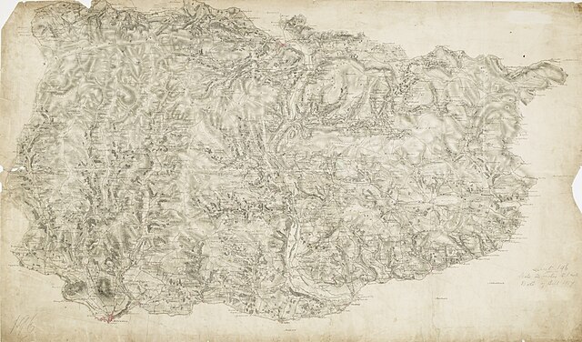
 Centre of map shown on a map of England
English: The Wye Valley runs from the top to the bottom of the sheet.Forming a natural border, the valley became a regular battleground throughout the Roman, Saxon Norman eras,and during the Marcher Wars in the reign of James I. To the left of the sheet are the peaks of Mynydd Eppynt. To the right, the border of England and Wales is marked by the ancient earth bank, Offa's Dyke. The castle town of Builth is depicted at the top of the sheet. Built at the end of the 12th century, the castle witnessed repeated conflicts, and frequently changed hands between the Welsh and English. After Edward I's campaign against the Welsh in 1277, the castle was refortified and transformed into a formidable fortress..
This image has been georeferenced.
|
||||
| Language |
English |
||||
| Date | 1817 | ||||
| Medium | Pen and ink on paper | ||||
| Dimensions | height: 320 mm (12.59 in); width: 530 mm (20.86 in) | ||||
| Collection | |||||
| Accession number |
Maps OSD 196 |
||||
| Credit line | British Library | ||||
| Notes |
Scale 2 inches : 1 mile (1:31680). Please note that the British Library provides these digital files "as-is"; materials will not be rephotographed under this programme. If resupply of files is required, the requestor will be required to purchase them at the standard rate. |
||||
| References |
http://www.bl.uk/onlinegallery/onlineex/ordsurvdraw/b/002osd000000022u00154000.html (English) |
||||
| Source/Photographer |
|
||||
| Permission (Reusing this file) |
|
||||


_(St_Edwards_Crown).svg)
.jpg¶ms=52.087888_N_-3.324_E_)
.jpg¶ms=51.89823_N_-3.665244_E_)
.jpg¶ms=52.277547_N_-2.982755_E_)
.jpg¶ms=52.073763_N_-3.665244_E_)
.jpg¶ms=51.89823_N_-3.472257_E_)
.jpg¶ms=52.102013_N_-2.982755_E_)
.jpg¶ms=52.277547_N_-3.175743_E_)
File history
Click on a date/time to view the file as it appeared at that time.
| Date/Time | Thumbnail | Dimensions | User | Comment | |
|---|---|---|---|---|---|
| current | 09:04, 26 September 2013 | | 5,747 × 3,375 (5.09 MB) | LibraryBot (talk | contribs) | {{subst:User:Andrew Gray/OSD|ID= 002OSD000000022U00154000 |OSD_NUM= OSD 196 |MEDIUM= Pen and ink on paper |TITLE= Builth, Powys |CREATOR= Budgen, Thomas - Draughtsman |YEAR= 1817 |DESCRIPTION= The Wye Valley runs from the top to the bottom of the sheet... |
You cannot overwrite this file.
File usage on Commons
The following 2 pages use this file:
.jpg&redirect=no)
File usage on other wikis
The following other wikis use this file:
- Usage on www.wikidata.org
.jpg&oldid=688968878)