File:Odienné Boundiali Korhogo.svg
Jump to navigation
Jump to search

Size of this PNG preview of this SVG file: 800 × 449 pixels. Other resolutions: 320 × 180 pixels | 640 × 360 pixels | 1,024 × 575 pixels | 1,280 × 719 pixels | 2,560 × 1,438 pixels | 826 × 464 pixels.
Original file (SVG file, nominally 826 × 464 pixels, file size: 3.19 MB)
Captions
Captions
Add a one-line explanation of what this file represents
Summary
[edit]| Description |
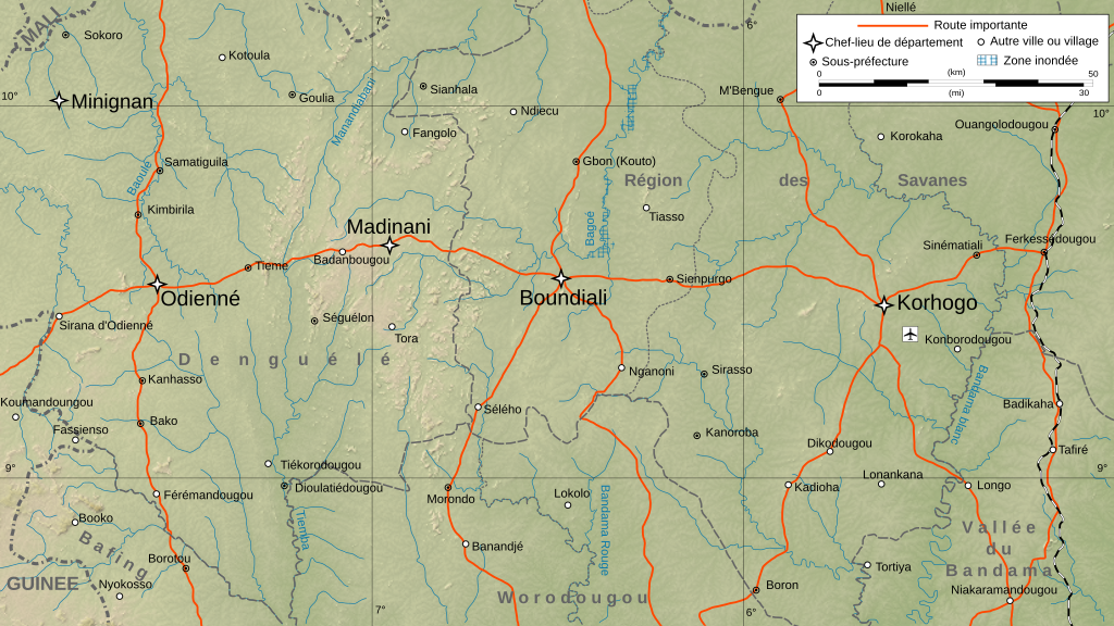
English: Map of Boundiali District in the Sahel sub-Saharan savanna region - in northern Ivory Coast - Côte d'Ivoire.
Français : Carte physique de la zone de Boundiali, avec une partie de la Région de Savanes (chef-lieu : Korhogo) et une partie de la région du Denguélé (chef-lieu : Odienné). Note : le fond de carte est un bitmap (SRTM30 v.2/domaine publique) embarqué dans le svg à l'aide d'Inkscape.
Échelle : 1:1 115 807 Equirectangular projection, WGS84 datum
|
| Date | |
| Source |
Own work
|
| Author | Bourrichon - fr:Bourrichon |
| Other versions |
|

Licensing
[edit]
I, the copyright holder of this work, hereby publish it under the following licenses:

|
Permission is granted to copy, distribute and/or modify this document under the terms of the GNU Free Documentation License, Version 1.2 or any later version published by the Free Software Foundation; with no Invariant Sections, no Front-Cover Texts, and no Back-Cover Texts. A copy of the license is included in the section entitled GNU Free Documentation License. |
This file is licensed under the Creative Commons Attribution-Share Alike Attribution-Share Alike 4.0 International, 3.0 Unported, 2.5 Generic, 2.0 Generic and 1.0 Generic license.
- You are free:
- to share – to copy, distribute and transmit the work
- to remix – to adapt the work
- Under the following conditions:
- attribution – You must give appropriate credit, provide a link to the license, and indicate if changes were made. You may do so in any reasonable manner, but not in any way that suggests the licensor endorses you or your use.
- share alike – If you remix, transform, or build upon the material, you must distribute your contributions under the same or compatible license as the original.
You may select the license of your choice.
File history
Click on a date/time to view the file as it appeared at that time.
| Date/Time | Thumbnail | Dimensions | User | Comment | |
|---|---|---|---|---|---|
| current | 14:39, 1 October 2008 | | 826 × 464 (3.19 MB) | Bourrichon (talk | contribs) | + correction des frontières internes (source : World Data bank II) |
| 13:21, 1 October 2008 |  | 826 × 464 (3.3 MB) | Bourrichon (talk | contribs) | {{Information |Description={{en|Map of Boundiali's Zone, with part of Région des Savanes and Denguélé, in the north of en:Ivory Coast.<br/>Scale : 1:1,115,807}} {{fr|Carte physique de la zone de Boundiali, avec une partie de la [ |
You cannot overwrite this file.
File usage on Commons
The following page uses this file:
File usage on other wikis
The following other wikis use this file:
- Usage on ca.wikipedia.org
- Usage on eo.wikipedia.org
- Usage on fr.wikipedia.org
- Usage on it.wikivoyage.org
- Usage on sd.wikipedia.org