File:Occupation sol wallonie.jpg
Jump to navigation
Jump to search

Size of this preview: 780 × 600 pixels. Other resolutions: 312 × 240 pixels | 624 × 480 pixels | 999 × 768 pixels | 1,078 × 829 pixels.
Original file (1,078 × 829 pixels, file size: 441 KB, MIME type: image/jpeg)
Captions
Captions
Add a one-line explanation of what this file represents
Summary[edit]
| Description |
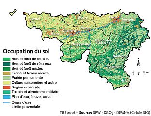
Français : Carte d'occupation du sol de la Région wallonne
English: Land use map of Walloon Region |
| Date | |
| Source | Cellule État de l'Environnement wallon (March 2008) "Partie 1 : Occupation du territoire" in Tableau de bord de l'environnement wallon 2008 (PDF) (Rapport sur l'état de l'environnement wallon ed.), SPW-DGARNE(DGO3)-DEMNA-DEE, pp. 11 Retrieved on 20 May 2009. D/2008/5322/45 |
| Author | Cellule État de l'environnement wallon |
| Permission (Reusing this file) |
Français : La reproduction et la diffusion de ce document ou de parties de celui-ci sont autorisées à condition de faire mention de la source sous la forme suivante : Cellule État de l'environnement wallon : Tableau de bord de l'environnement wallon 2008, SPW-DGARNE(DGO3)-DEMNA-DEE
English: The reproduction and distribution of all part of this document are permitted as long as the source is quoted, in the following format: Cellule État de l'environnement wallon : Environmental Outlook for Wallonia 2008, SPW-DGARNE(DGO3)-DEMNA-DEE |
Licensing[edit]
This file is licensed under the Creative Commons Attribution-Share Alike 1.0 Generic license.
- You are free:
- to share – to copy, distribute and transmit the work
- to remix – to adapt the work
- Under the following conditions:
- attribution – You must give appropriate credit, provide a link to the license, and indicate if changes were made. You may do so in any reasonable manner, but not in any way that suggests the licensor endorses you or your use.
- share alike – If you alter, transform, or build upon this work, you must distribute the resulting work under the same license as the original.
File history
Click on a date/time to view the file as it appeared at that time.
| Date/Time | Thumbnail | Dimensions | User | Comment | |
|---|---|---|---|---|---|
| current | 12:19, 20 May 2009 | | 1,078 × 829 (441 KB) | Mariusg2 (talk | contribs) | {{Information |Description={{fr|1=Carte d'occupation du sol de la Région wallonne (Wallonie)}} {{en|1=Land use map of Wallonia}} |Source={{cite book | last = Cellule État de l'Environnement wallon | first = | coauthor= | year = 20 |
You cannot overwrite this file.
File usage on Commons
The following page uses this file:
File usage on other wikis
The following other wikis use this file:
- Usage on el.wikipedia.org
- Usage on fr.wikipedia.org