File:Oc rivers master map final.jpg
Jump to navigation
Jump to search

Size of this preview: 800 × 586 pixels. Other resolutions: 320 × 235 pixels | 640 × 469 pixels | 985 × 722 pixels.
Original file (985 × 722 pixels, file size: 869 KB, MIME type: image/jpeg)
Captions
Captions
Add a one-line explanation of what this file represents
Summary[edit]
| Description |
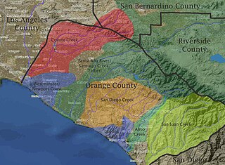
English: Orange County watersheds map for use in corresponding article |
|
| Source | http://www.planiglobe.com/omc_set.html | |
| Author | planiglobe and edited by Shannon1 | |
| Permission (Reusing this file) |
|
Licensing[edit]
This file is licensed under the Creative Commons Attribution-Share Alike 3.0 Unported license.
- You are free:
- to share – to copy, distribute and transmit the work
- to remix – to adapt the work
- Under the following conditions:
- attribution – You must give appropriate credit, provide a link to the license, and indicate if changes were made. You may do so in any reasonable manner, but not in any way that suggests the licensor endorses you or your use.
- share alike – If you remix, transform, or build upon the material, you must distribute your contributions under the same or compatible license as the original.
File history
Click on a date/time to view the file as it appeared at that time.
| Date/Time | Thumbnail | Dimensions | User | Comment | |
|---|---|---|---|---|---|
| current | 21:40, 22 January 2010 | | 985 × 722 (869 KB) | Shannon1 (talk | contribs) | {{Information |Description={{en|1=Orange County watersheds map for use in corresponding article}} |Source=http://www.planiglobe.com/omc_set.html |Author=planiglobe and edited by Shannon1 |Date= |Permission={{planiglobe}} |other_versions= }} [[Category:Ri |
You cannot overwrite this file.
File usage on Commons
There are no pages that use this file.
File usage on other wikis
The following other wikis use this file:
- Usage on fr.wikipedia.org