File:Oberfallenberg Dornbirn.JPG
Original file (4,288 × 2,848 pixels, file size: 2.66 MB, MIME type: image/jpeg)
Captions
Summary[edit]
DescriptionOberfallenberg Dornbirn.JPG |
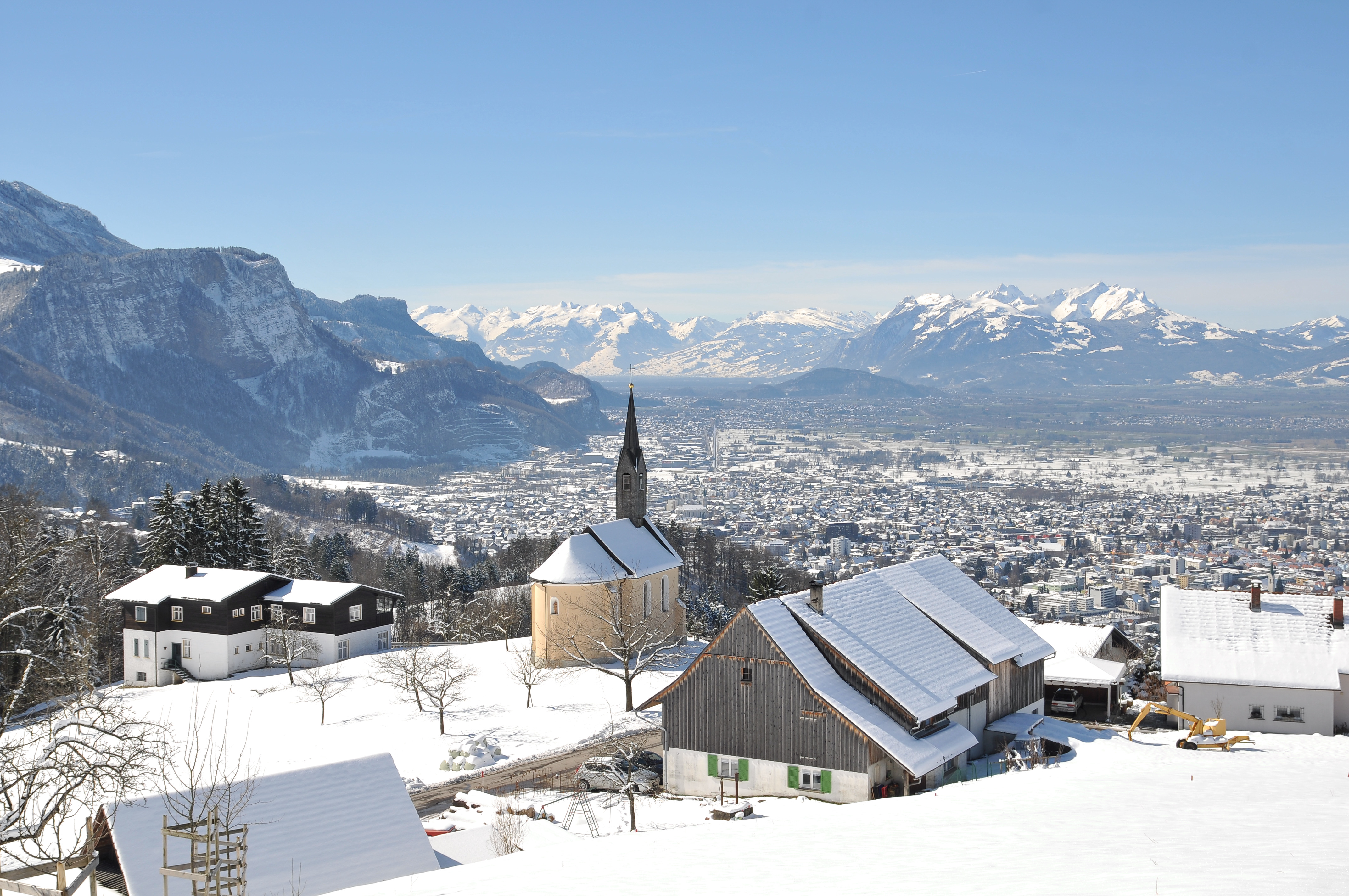
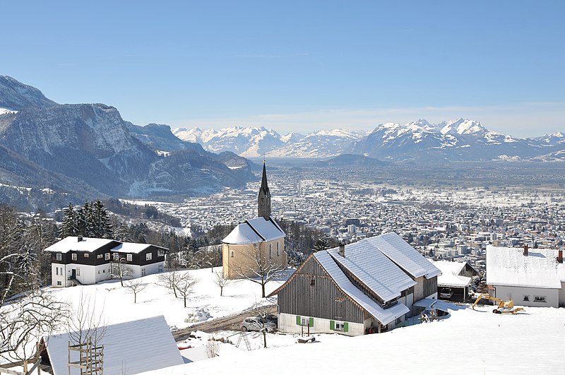
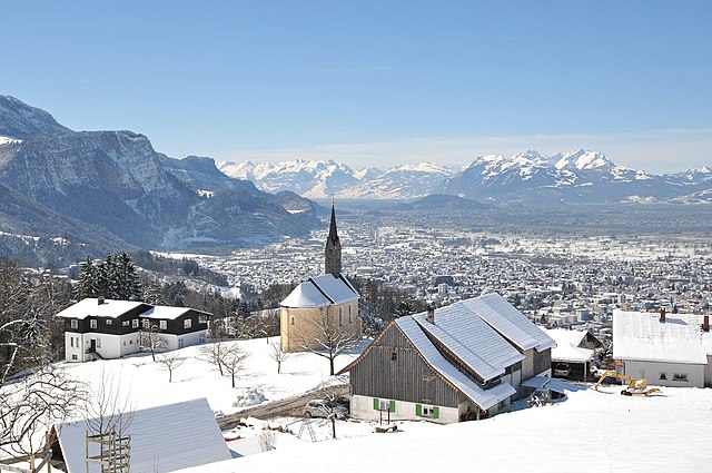
Deutsch: Blick über die Kapelle Hl. Ottilie in Oberfallenberg über Dornbirn, das Rheintal und auf die Schweizer Berge des Alpsteins und Alviers.
|
||
Date | |||
Source | Own work | ||
Author |
|
||
Permission (Reusing this file) |
I, the copyright holder of this work, hereby publish it under the following licenses:
This file is licensed under the Creative Commons Attribution-Share Alike 3.0 Austria license.
You may select the license of your choice. |
Object location | 47° 25′ 18.84″ N, 9° 46′ 07.18″ E | View this and other nearby images on: OpenStreetMap | 47.421900; 9.768660 |
---|
Camera location | 47° 25′ 21.29″ N, 9° 46′ 11.97″ E | View this and other nearby images on: OpenStreetMap | 47.422581; 9.769992 |
---|
Annotations InfoField | This image is annotated: View the annotations at Commons |
Altmann
Säntis
Churfirsten
Hoher Kasten
Kapf
Alviergebirge
Chäserugg
Assessment[edit]
This image has been assessed using the Quality image guidelines and is considered a Quality image.
العربية ∙ جازايرية ∙ беларуская ∙ беларуская (тарашкевіца) ∙ български ∙ বাংলা ∙ català ∙ čeština ∙ Cymraeg ∙ Deutsch ∙ Schweizer Hochdeutsch ∙ Zazaki ∙ Ελληνικά ∙ English ∙ Esperanto ∙ español ∙ eesti ∙ euskara ∙ فارسی ∙ suomi ∙ français ∙ galego ∙ עברית ∙ हिन्दी ∙ hrvatski ∙ magyar ∙ հայերեն ∙ Bahasa Indonesia ∙ italiano ∙ 日本語 ∙ Jawa ∙ ქართული ∙ 한국어 ∙ kurdî ∙ Lëtzebuergesch ∙ lietuvių ∙ македонски ∙ മലയാളം ∙ मराठी ∙ Bahasa Melayu ∙ Nederlands ∙ Norfuk / Pitkern ∙ polski ∙ português ∙ português do Brasil ∙ rumantsch ∙ română ∙ русский ∙ sicilianu ∙ slovenčina ∙ slovenščina ∙ shqip ∙ српски / srpski ∙ svenska ∙ தமிழ் ∙ తెలుగు ∙ ไทย ∙ Tagalog ∙ Türkçe ∙ toki pona ∙ українська ∙ vèneto ∙ Tiếng Việt ∙ 中文 ∙ 中文(简体) ∙ 中文(繁體) ∙ +/− |
This image was selected as picture of the day on Vietnamese Wikipedia for 30 December 2022.
|
File history
Click on a date/time to view the file as it appeared at that time.
Date/Time | Thumbnail | Dimensions | User | Comment | |
---|---|---|---|---|---|
current | 21:57, 17 March 2013 | 4,288 × 2,848 (2.66 MB) | Böhringer (talk | contribs) | {{Information |Description= {{de|Blick über dir Kapelle Hl. Ottilie in Oberfallenberg über Dornbirn, das Rheintal und auf die Schweizer Berge des Alpsteins und Alviers.}} {{Denkmalgeschütztes Objekt Österreich|1=6908}} |Source= {{O... |
You cannot overwrite this file.
File usage on Commons
The following 5 pages use this file:
File usage on other wikis
The following other wikis use this file:
- Usage on ceb.wikipedia.org
- Usage on cs.wikipedia.org
- Usage on de.wikipedia.org
- Usage on en.wikipedia.org
- Usage on es.wikipedia.org
- Usage on he.wikipedia.org
- Usage on hu.wikipedia.org
- Usage on lld.wikipedia.org
- Usage on pl.wikipedia.org
- Usage on pt.wikipedia.org
- Usage on ru.wikipedia.org
- Usage on tg.wikipedia.org
- Usage on vec.wikipedia.org
- Usage on vi.wikipedia.org
- Usage on www.wikidata.org
Metadata
This file contains additional information such as Exif metadata which may have been added by the digital camera, scanner, or software program used to create or digitize it. If the file has been modified from its original state, some details such as the timestamp may not fully reflect those of the original file. The timestamp is only as accurate as the clock in the camera, and it may be completely wrong.
Camera manufacturer | NIKON CORPORATION |
---|---|
Camera model | NIKON D300S |
Author | Boehringer Fiedrich (Fred) |
Copyright holder | Boehringer Friedrich |
Exposure time | 1/320 sec (0.003125) |
F-number | f/9 |
Date and time of data generation | 12:16, 16 March 2013 |
Lens focal length | 28 mm |
User comments | NENNE DEN AUTOR! !!URHEBERRECHT!!! |
Orientation | Normal |
Horizontal resolution | 300 dpi |
Vertical resolution | 300 dpi |
Software used | Capture NX 2.2.5 W |
File change date and time | 22:33, 17 March 2013 |
Y and C positioning | Centered |
Exposure Program | Manual |
Exif version | 2.21 |
Date and time of digitizing | 12:16, 16 March 2013 |
Meaning of each component |
|
APEX exposure bias | 0 |
Maximum land aperture | 3.4 APEX (f/3.25) |
Metering mode | Pattern |
Light source | Unknown |
Flash | Flash did not fire |
DateTime subseconds | 86 |
DateTimeOriginal subseconds | 86 |
DateTimeDigitized subseconds | 86 |
Supported Flashpix version | 1 |
Color space | Uncalibrated |
Sensing method | One-chip color area sensor |
File source | Digital still camera |
Scene type | A directly photographed image |
Custom image processing | Normal process |
Exposure mode | Manual exposure |
White balance | Auto white balance |
Digital zoom ratio | 1 |
Focal length in 35 mm film | 42 mm |
Scene capture type | Standard |
Scene control | None |
Contrast | Normal |
Saturation | Normal |
Sharpness | Hard |
Subject distance range | Unknown |
GPS tag version | 0.0.2.2 |
Structured data
Items portrayed in this file
depicts
16 March 2013
47°25'21.292"N, 9°46'11.971"E
47°25'18.840"N, 9°46'7.176"E
0.003125 second
28 millimetre
image/jpeg
- Cultural heritage monuments in Austria with known IDs
- Photos by Böhringer
- License migration redundant
- GFDL
- CC-BY-SA-3.0-AT
- Self-published work
- Images with annotations
- Quality images
- Quality images missing SDC creator
- Featured pictures on Wikipedia, Vietnamese
- Quality images of cultural heritage monuments in Austria
- Quality images of snow
- Quality images of valleys
- Pages with maps