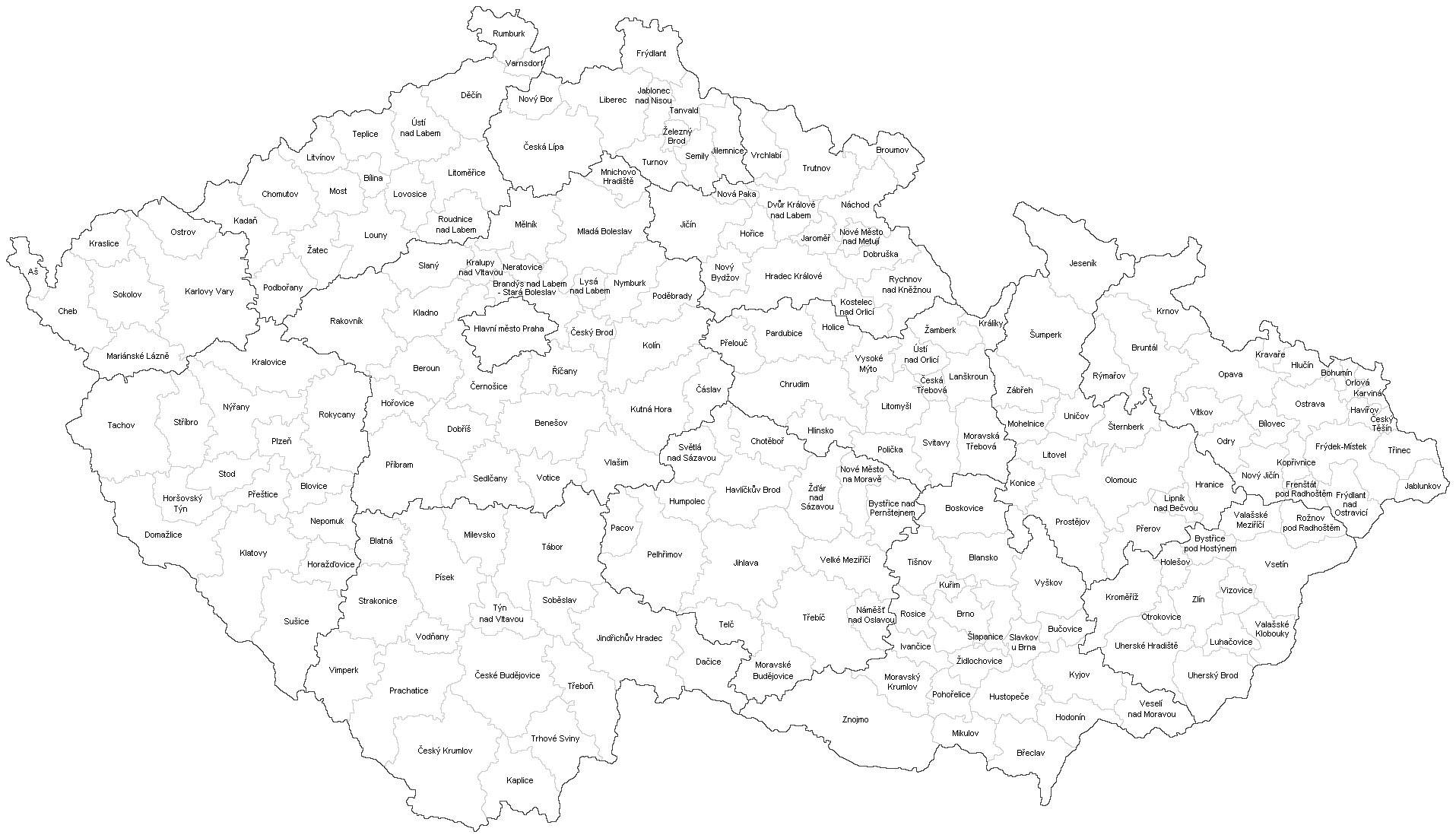
File:ORP.PNG
Jump to navigation
Jump to search
Size of this preview: 800 × 460 pixels. Other resolutions: 320 × 184 pixels | 640 × 368 pixels | 1,024 × 589 pixels | 1,280 × 737 pixels | 1,915 × 1,102 pixels.
Original file (1,915 × 1,102 pixels, file size: 136 KB, MIME type: image/png)
Captions
Captions
Add a one-line explanation of what this file represents

|
This locator map image could be re-created using vector graphics as an SVG file. This has several advantages; see Commons:Media for cleanup for more information. If an SVG form of this image is available, please upload it and afterwards replace this template with
{{vector version available|new image name}}.
It is recommended to name the SVG file “ORP.svg”—then the template Vector version available (or Vva) does not need the new image name parameter. |
Summary
[edit]
| Description |
English: Map of small districts (districts of municipalities with extended powers) in The Czech republic (created by the model of districts)
Čeština: Mapa malých okresů (obvody obcí s rozšířenou působností) České republiky (vytvořeno podle vzoru okresů)
Deutsch: Karte der kleinen Bezirke (ORP-Kommunen mit erweiterten Befugnissen) in der Tschechischen Republik. |
| Date | 9.4.2011 |
| Source | Own work |
| Author | Hustoles |
Licensing
[edit]
| I, the copyright holder of this work, release this work into the public domain. This applies worldwide. In some countries this may not be legally possible; if so: I grant anyone the right to use this work for any purpose, without any conditions, unless such conditions are required by law. |
File history
Click on a date/time to view the file as it appeared at that time.
| Date/Time | Thumbnail | Dimensions | User | Comment | |
|---|---|---|---|---|---|
| current | 10:53, 3 January 2016 | | 1,915 × 1,102 (136 KB) | Valdemar (talk | contribs) | white |
| 20:31, 2 January 2016 |  | 1,915 × 1,102 (136 KB) | Valdemar (talk | contribs) | correction | |
| 20:03, 2 January 2016 |  | 1,915 × 1,102 (135 KB) | Valdemar (talk | contribs) | colors | |
| 18:39, 2 January 2016 |  | 1,915 × 1,102 (135 KB) | Valdemar (talk | contribs) | correction | |
| 18:10, 2 January 2016 |  | 1,915 × 1,102 (135 KB) | Valdemar (talk | contribs) | new borders (law no. 15/2015 Coll.) | |
| 21:21, 13 February 2013 |  | 1,915 × 1,102 (177 KB) | Fext (talk | contribs) | Pootočení, zpřesnění | |
| 19:41, 9 April 2011 |  | 1,379 × 853 (110 KB) | Hustoles (talk | contribs) | {{Information |Description ={{en|1=Map of small districts (districts of municipalities with extended powers) in The Czech republic (created by the model of districts)}} {{cs|1=Mapa malých okresů (obvody obcí s rozšířenou působností) České rep |
You cannot overwrite this file.
File usage on Commons
There are no pages that use this file.
File usage on other wikis
The following other wikis use this file:
- Usage on cs.wikipedia.org
- Usage on de.wikipedia.org
- Usage on en.wikipedia.org
- Usage on no.wikipedia.org
- Usage on pl.wikipedia.org
- Usage on sk.wikipedia.org