File:NowaMapaS52.svg
Jump to navigation
Jump to search

Size of this PNG preview of this SVG file: 643 × 599 pixels. Other resolutions: 258 × 240 pixels | 515 × 480 pixels | 824 × 768 pixels | 1,099 × 1,024 pixels | 2,198 × 2,048 pixels | 776 × 723 pixels.
Original file (SVG file, nominally 776 × 723 pixels, file size: 172 KB)
Captions
Captions
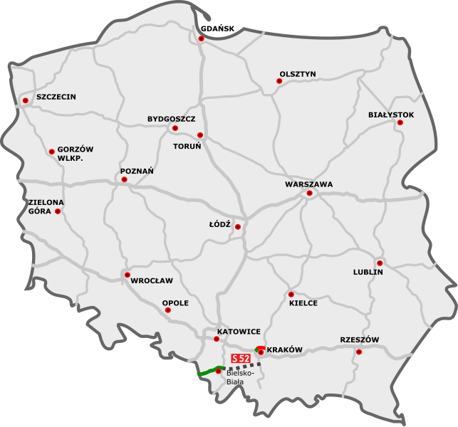
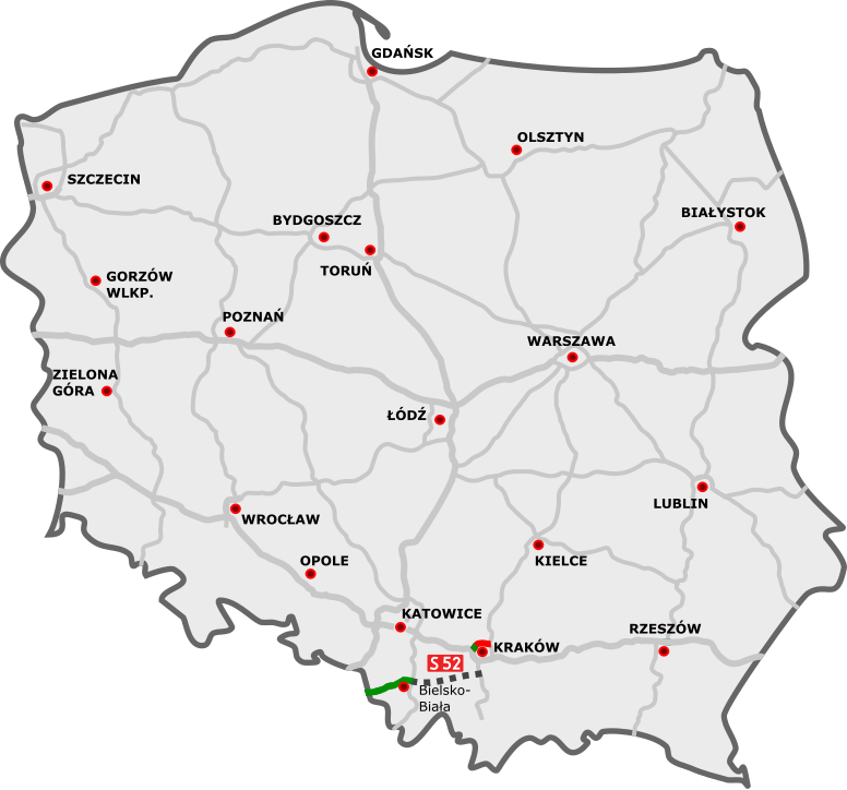
S52 Expressway on the map of Poland
Any autoconfirmed user can overwrite this file from the same source. Please ensure that overwrites comply with the guideline.
| Description | |
| Date | |
| Source |
|
| Author |
I, the copyright holder of this work, hereby publish it under the following license:
This file is licensed under the Creative Commons Attribution 3.0 Unported license.
- You are free:
- to share – to copy, distribute and transmit the work
- to remix – to adapt the work
- Under the following conditions:
- attribution – You must give appropriate credit, provide a link to the license, and indicate if changes were made. You may do so in any reasonable manner, but not in any way that suggests the licensor endorses you or your use.
File history
Click on a date/time to view the file as it appeared at that time.
| Date/Time | Thumbnail | Dimensions | User | Comment | |
|---|---|---|---|---|---|
| current | 18:35, 22 May 2022 | | 776 × 723 (172 KB) | Kirt93 (talk | contribs) | Update |
| 20:27, 27 August 2016 |  | 776 × 723 (174 KB) | Daniel749 (talk | contribs) | {{Information |Description={{pl|Przebieg drogi S52:}} {{Legend||line=7px solid #009100|odcinki istniejące}} {{Legend||line=7px solid red|odcinki w budowie}} {{Legend||line=7px dotted #444444|odcinki projektowane}}... |
You cannot overwrite this file.
File usage on Commons
The following 7 pages use this file:
- User:Chumwa/OgreBot/Potential transport maps/2016 August 21-31
- User:Chumwa/OgreBot/Transport Maps/2016 August 21-31
- User:Chumwa/OgreBot/Transport Maps/2022 May 21-31
- User:Chumwa/OgreBot/Travel and communication maps/2016 August 21-31
- User:Chumwa/OgreBot/Travel and communication maps/2022 May 21-31
- Commons:Files used on the AARoads Wiki/89
- Category:Expressway S52 (Poland)
File usage on other wikis
The following other wikis use this file:
- Usage on cs.wikipedia.org
- Usage on de.wikipedia.org
- Usage on en.wikipedia.org
- Usage on fr.wikipedia.org
- Usage on hu.wikipedia.org
- Usage on lmo.wikipedia.org
- Usage on nl.wikipedia.org
- Usage on pl.wikipedia.org
- Usage on ro.wikipedia.org
- Usage on uk.wikipedia.org
- Usage on vi.wikipedia.org
- Usage on www.wikidata.org