File:Novozelandske kralovstvi.jpg
Jump to navigation
Jump to search
Size of this preview: 600 × 600 pixels. Other resolutions: 240 × 240 pixels | 480 × 480 pixels | 1,000 × 1,000 pixels.
Original file (1,000 × 1,000 pixels, file size: 84 KB, MIME type: image/jpeg)
Captions
Captions
Add a one-line explanation of what this file represents
| Description |
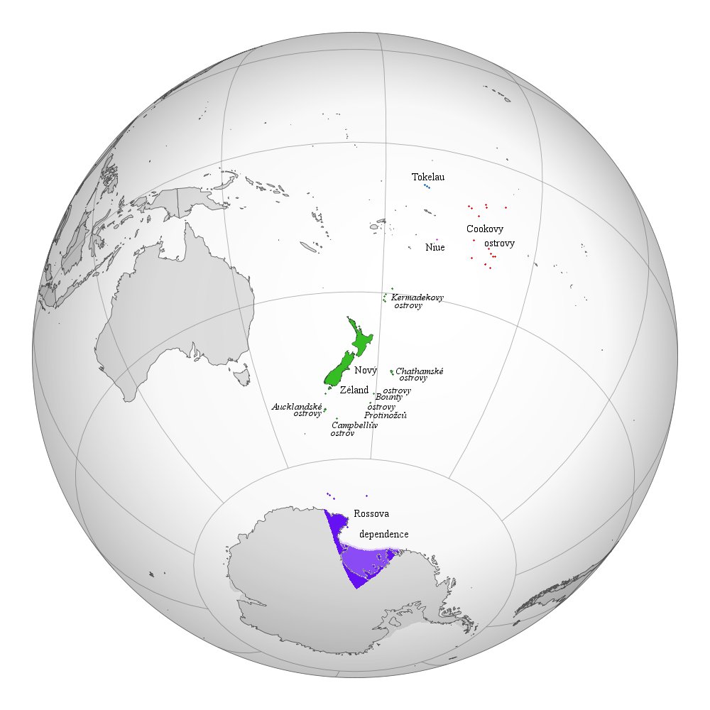
English: A map of the hemisphere centred on Wellington, New Zealand, using an orthographic projection, created using gringer's Perl script with Natural Earth Data (1:50000 resolution, simplified to 0.25px). New Zealand is highlighted in green. |
| Date | (UTC) |
| Source | File:NZL orthographic NaturalEarth.svg |
| Author |
File:NZL orthographic NaturalEarth.svg: Gringer
|
| Other versions |
|
_2.svg)
| This is a retouched picture, which means that it has been digitally altered from its original version. Modifications: adapted for Realm of New Zealand. The original can be viewed here: NZL orthographic NaturalEarth.svg:
|

|
This locator map image could be re-created using vector graphics as an SVG file. This has several advantages; see Commons:Media for cleanup for more information. If an SVG form of this image is available, please upload it and afterwards replace this template with
{{vector version available|new image name}}.
It is recommended to name the SVG file “Novozelandske kralovstvi.svg”—then the template Vector version available (or Vva) does not need the new image name parameter. |


I, the copyright holder of this work, hereby publish it under the following license:
| I, the copyright holder of this work, release this work into the public domain. This applies worldwide. In some countries this may not be legally possible; if so: I grant anyone the right to use this work for any purpose, without any conditions, unless such conditions are required by law. |
Original upload log[edit]
This image is a derivative work of the following images:
- File:NZL_orthographic_NaturalEarth.svg licensed with PD-self
- 2010-09-01T04:35:14Z Gringer 550x550 (407243 Bytes) Using high resolution (10m) shapes for New Zealand, removed odd Antarctica spike.
- 2010-08-30T23:13:57Z Gringer 550x550 (256025 Bytes) changed size to fit with recommendations, white sea
- 2010-08-30T22:54:32Z Gringer 1050x1050 (254568 Bytes) {{Information |Description={{en|1=A map of the hemisphere centred on Wellington, New Zealand, using an orthographic projection, created using [[User:Gringer|gringer]]'s [[[w:User:Gringer/perlshaper|Perl script] with [http://w
Uploaded with derivativeFX
File history
Click on a date/time to view the file as it appeared at that time.
| Date/Time | Thumbnail | Dimensions | User | Comment | |
|---|---|---|---|---|---|
| current | 15:31, 11 November 2010 | | 1,000 × 1,000 (84 KB) | Vrata~commonswiki (talk | contribs) | {{Information |Description={{en|1=A map of the hemisphere centred on Wellington, New Zealand, using an orthographic projection, created using gringer's Perl script with [http://www.naturalearthdata.com/ Natur |
You cannot overwrite this file.
File usage on Commons
The following 4 pages use this file:
_(New_Zealand_centered).svg)
_(New_Zealand_centered).svg)
.svg)
File usage on other wikis
The following other wikis use this file:
- Usage on cs.wikipedia.org