File:Novate Milanese - mappa unità di paesaggio.svg
Jump to navigation
Jump to search

Size of this PNG preview of this SVG file: 565 × 600 pixels. Other resolutions: 226 × 240 pixels | 452 × 480 pixels | 724 × 768 pixels | 965 × 1,024 pixels | 1,929 × 2,048 pixels | 814 × 864 pixels.
Original file (SVG file, nominally 814 × 864 pixels, file size: 1.63 MB)
Captions
Captions
Add a one-line explanation of what this file represents
Summary
[edit]| Description |
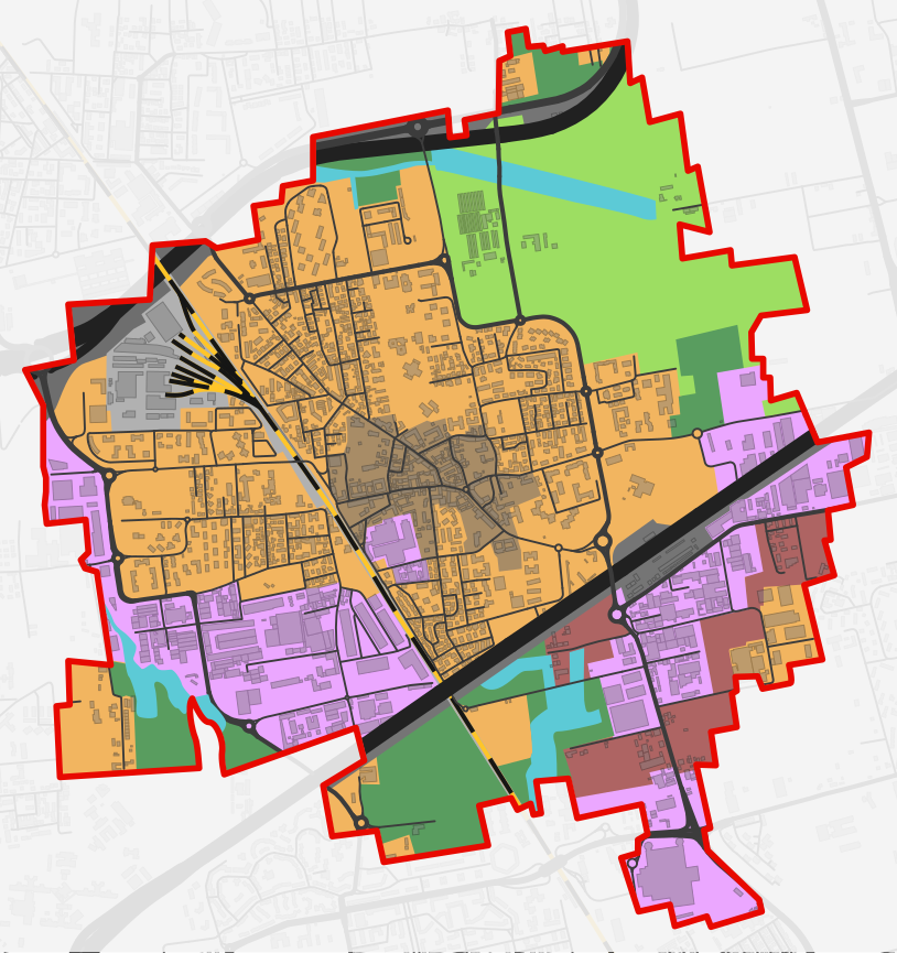
Italiano: Mappa vettoriale di Novate Milanese per unità tipologiche del paesaggio, in base alla classificazione dell'anno 2012.
italiano (it): Unità tipologiche del paesaggio
Città storica Città moderna Città produttiva Territorio frammentato Territorio libero infra-urbano Territorio agricolo compatto Elementi della pianura irrigua Ferrovia Grandi vie di comunicazione
|
||||
| Date | |||||
| Source | Own work. Based on (Novate Milanese) PdR.T01 - Unità tipologiche del paesaggio - Dicembre 2012.pdf (original work in the public domain) for colored areas, and based on OpenStreetMap for roads, railways, buildings, borders. | ||||
| Author |
|
||||
| Permission (Reusing this file) |
|
||||
| Other versions |
|

File history
Click on a date/time to view the file as it appeared at that time.
| Date/Time | Thumbnail | Dimensions | User | Comment | |
|---|---|---|---|---|---|
| current | 12:03, 29 April 2024 | | 814 × 864 (1.63 MB) | Arrow303 (talk | contribs) | missing road + minor fix |
| 13:18, 28 April 2024 |  | 814 × 864 (1.62 MB) | Arrow303 (talk | contribs) | transparency | |
| 13:11, 28 April 2024 |  | 814 × 864 (1.71 MB) | Arrow303 (talk | contribs) | minor edits | |
| 13:05, 28 April 2024 |  | 814 × 864 (1.62 MB) | Arrow303 (talk | contribs) | {{Information |Description={{it|Mappa vettoriale di Novate Milanese per unità tipologiche del paesaggio, in base alla classificazione dell'anno 2012.}} {{Legend-table|lang=it|title=Unità tipologiche del paesaggio|align=left |#a88c66|Città storica |#f2b560|Città moderna |#eba7ff|Città produttiva |#ae6463|Territorio frammentato |#599d5f|Territorio libero infra-urbano |#9dde62|Territorio agricolo compatto |#5ccad6|Elementi della pianura irrigua |#b1b1b1|Ferrovia |#6e6e6e|Grandi vie di comunicazi... |
You cannot overwrite this file.
File usage on Commons
The following page uses this file:
File usage on other wikis
The following other wikis use this file:
- Usage on it.wikipedia.org