File:Nova & accuratissima totius terrarum orbis tabula nautica variationum magneticarum index juxta observationes Anno 1700 (NYPL b13909432-1640713).jpg

Original file (11,504 × 4,912 pixels, file size: 14.07 MB, MIME type: image/jpeg)
Captions
Captions
Summary[edit]
| Description |
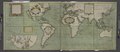
English: * Contains 8 pages of text and 173 double-page large folio charts, colored by a contemporary hand.
|
||
| Title | Nova & accuratissima totius terrarum orbis tabula nautica variationum magneticarum index juxta observationes Anno 1700 | ||
| Alternative title | A new and correct sea chart of the whole world shewing the variations of the compass as they were found in the year MDCC | ||
| Date | |||
| Source | https://digitalcollections.nypl.org/items/510d47e4-6606-a3d9-e040-e00a18064a99 | ||
| Author | Scan by NYPL | ||
| Permission (Reusing this file) |
|
||
| Other versions |
|
||
| UUID | d4e95530-c602-012f-438f-58d385a7bc34 | ||
| MODS | http://api.repo.nypl.org/api/v1/items/mods/510d47e4-6606-a3d9-e040-e00a18064a99 | ||
| Origin place | London | ||
| Image ID | 1640713 | ||
| Collection | Atlases, gazetteers, guidebooks and other books | ||
| Collection UUID | 510d47e4-6606-a3d9-e040-e00a18064a99 | ||
| NYPL catalog ID | b13909432 | ||
| NYPL Division | Lionel Pincus and Princess Firyal Map Division | ||
| Topics | Nautical charts; World maps |


.jpg&action=edit§ion=1)
Licensing[edit]
.jpg&action=edit§ion=2)
This image is in the public domain because it is a mere mechanical scan or photocopy of a public domain original, or – from the available evidence – is so similar to such a scan or photocopy that no copyright protection can be expected to arise. The original itself is in the public domain for the following reason:
This tag is designed for use where there may be a need to assert that any enhancements (eg brightness, contrast, colour-matching, sharpening) are in themselves insufficiently creative to generate a new copyright. It can be used where it is unknown whether any enhancements have been made, as well as when the enhancements are clear but insufficient. For known raw unenhanced scans you can use an appropriate {{PD-old}} tag instead. For usage, see Commons:When to use the PD-scan tag.  | ||||
File history
Click on a date/time to view the file as it appeared at that time.
| Date/Time | Thumbnail | Dimensions | User | Comment | |
|---|---|---|---|---|---|
| current | 13:33, 12 August 2016 | | 11,504 × 4,912 (14.07 MB) | Fæ (talk | contribs) | Atlases, gazetteers http://digitalcollections.nypl.org/items/510d47e4-6606-a3d9-e040-e00a18064a99, part of User:Fæ/Project list/NYPL J64.66 |
You cannot overwrite this file.
File usage on Commons
The following 4 pages use this file:
- File:1701-E.Halley World Chart of the equal declination.jpg
- File:Accuratissima totius terrarum orbis tabula nautica - celeberrimo viro Edmd. Halley, LLD., anno 1700 contructa; indice variationes magneticas denota(m?) ad observationes circiter annu 1744 habitas NYPL465004.tiff
- File:Nova and accuratissima totius terrarum orbis tabula nautica variationum magneticarum index juxta observationes Anno 1700 - habitas constructa per Edm. Halley NYPL1640713.jpg
- File:Nova and accuratissima totius terrarum orbis tabula nautica variationum magneticarum index juxta observationes Anno 1700 - habitas constructa per Edm. Halley NYPL1640713.tiff
.jpg&oldid=715793670)
- NYPL Lionel Pincus and Princess Firyal Map Division
- NYPL collection of Atlases, gazetteers, guidebooks and other books
- Maps by Samuel Thornton
- A New and correct Sea Chart of the whole World, shewing the Variations of the Compass, as they were found Anno 1700
- 1700s maps of the world
- Island of California on world maps