File:Nile River Delta, Mediterranean Sea and Cyprus (MODIS 2016-06-29).jpg

Original file (4,221 × 3,292 pixels, file size: 1.02 MB, MIME type: image/jpeg)
Captions
Captions
Summary[edit]
.jpg&action=edit§ion=1)
| Description |
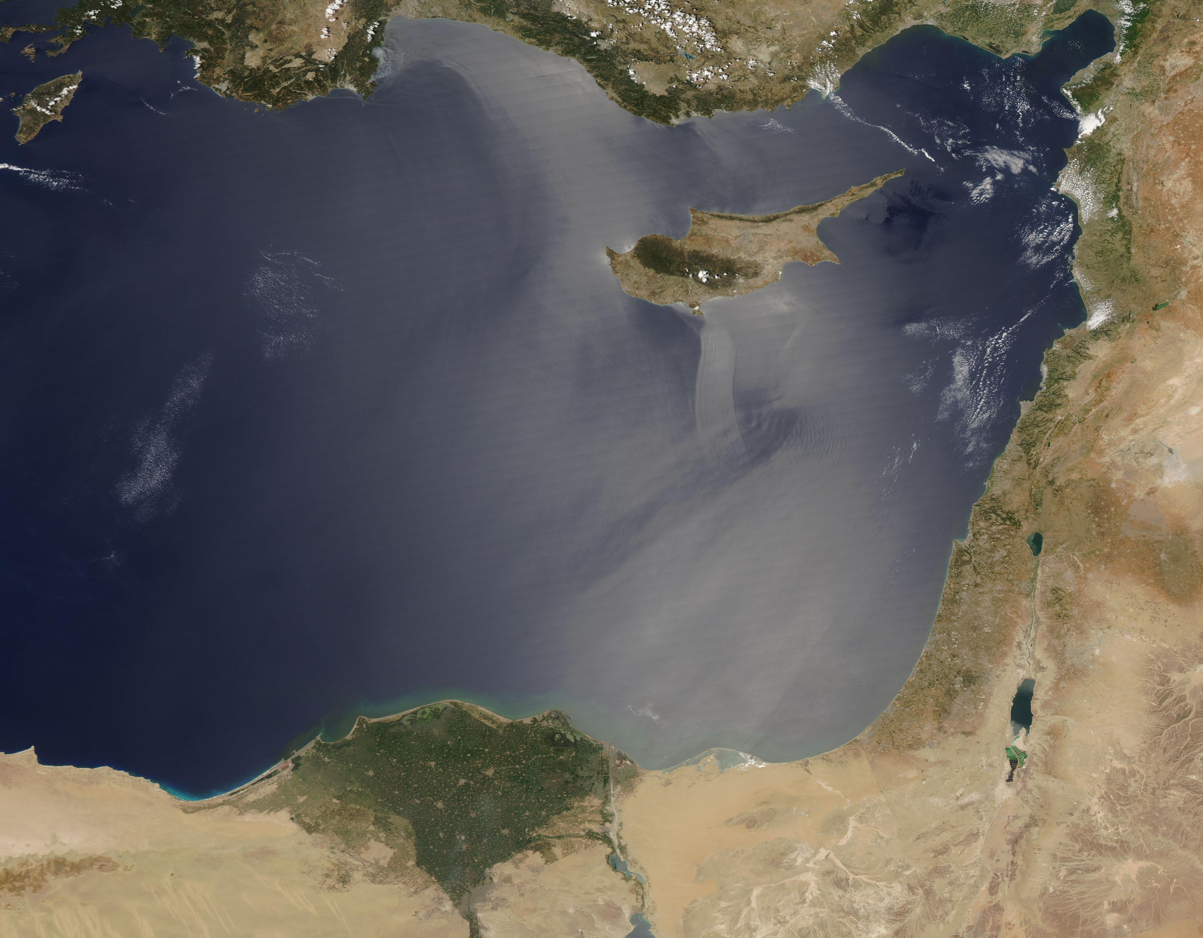
English: The Moderate Resolution Imaging Spectroradiometer (MODIS) aboard NASA's Aqua satellite acquired a beautiful true-color, clear-sky image of the Nile River Delta, the Mediterranean Sea and Cyprus as it passed over the region on June 26, 2016.
Cyprus is the third largest island in the Mediterranean Sea and is about 0.6 times the size of the state of Connecticut. The island's most notable features are two mountain ranges, both of which appear green in an otherwise mostly tan landscape. The Troodos Mountains sit in the southwest and are home to Mount Olympus, rising to 6,404 feet (1,952 meters). The Kyrenia Mountains roughly parallel the northern coastline. Contrasting with the tan coloration of the dry lands of Cyprus, the Nile River Delta appears as a bright green triangle in northern Egypt. The green delta, rich in moisture and vegetation, is dotted with gray-brown circles. These circles represent cities and human habitation. When viewed at higher resolution, these circles can be seen to be interconnected by a spider web of lines (roads) and many other smaller circles are visible in the well-settled delta. The Mediterranean Sea appears a silvery color due to a phenomenon called sunglint. Sunglint is caused by light reflection off a water surface; some of the reflected light travels directly back to the observer (the satellite), resulting in a bright mirror-like appearance over large expanses of water. Sunglint can reveal some features of water that are not easily visible otherwise. Water currents and changes in surface tension (typically caused by the presence of oils or surfactants) alter the reflective property of the water and can be highlighted by sunglint. For example, surface water currents are visible south of Cyprus. One streaks southward, smaller near the island and widening as it moves into the Mediterranean. This is likely due to turbulent wind from the high peak of Mount Olympus, found in the center of the Troodos Mountain Range. |
||
| Date | Taken on 26 June 2016 | ||
| Source |
Nile River Delta, Mediterranean Sea and Cyprus (direct link)
|
||
| Author | Jeff Schmaltz, MODIS Land Rapid Response Team, NASA GSFC |
| This media is a product of the Aqua mission Credit and attribution belongs to the mission team, if not already specified in the "author" row |
Licensing[edit]
.jpg&action=edit§ion=2)
| This file is in the public domain in the United States because it was solely created by NASA. NASA copyright policy states that "NASA material is not protected by copyright unless noted". (See Template:PD-USGov, NASA copyright policy page or JPL Image Use Policy.) | ||
 |
Warnings:
|
File history
Click on a date/time to view the file as it appeared at that time.
| Date/Time | Thumbnail | Dimensions | User | Comment | |
|---|---|---|---|---|---|
| current | 19:29, 15 February 2024 | | 4,221 × 3,292 (1.02 MB) | OptimusPrimeBot (talk | contribs) | #Spacemedia - Upload of http://modis.gsfc.nasa.gov/gallery/images/image06292016_250m.jpg via Commons:Spacemedia |
You cannot overwrite this file.
File usage on Commons
There are no pages that use this file.
.jpg&oldid=852328211)