File:Nh-pluto-map.jpg

Original file (985 × 493 pixels, file size: 53 KB, MIME type: image/jpeg)
Captions
Captions
Summary[edit]
| Description |
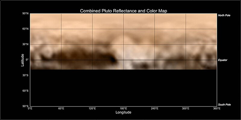
Original caption: This map of Pluto, created from images taken from June 27-July 3, 2015, by the Long Range Reconnaissance Imager (LORRI) on New Horizons, was combined with lower-resolution color data from the spacecraft's Ralph instrument. The center of the map corresponds to the side of Pluto that will be seen close-up during New Horizons' July 14 flyby. This map gives mission scientists an important tool to decipher the complex and intriguing pattern of bright and dark markings on Pluto's surface. Features from all sides of Pluto can now be seen at a glance and from a consistent perspective, making it much easier to compare their shapes and sizes. The elongated dark area informally known as "the whale," along the equator on the left side of the map, is one of the darkest regions visible to New Horizons. It measures some 1,860 miles (3,000 kilometers) in length. Directly to the right of the whale’s "snout" is the brightest region visible on the planet, which is roughly 990 miles (1,600 kilometers) across. This may be a region where relatively fresh deposits of frost—perhaps including frozen methane, nitrogen and/or carbon monoxide—form a bright coating. |
| Date | between 27 June 2015 and 3 July 2015 |
| Source | http://pluto.jhuapl.edu/Multimedia/Science-Photos/image.php?gallery_id=2&image_id=204 (image link) |
| Author | NASA/Johns Hopkins University Applied Physics Laboratory/Southwest Research Institute |
This image or video was catalogued by Jet Propulsion Laboratory of the United States National Aeronautics and Space Administration (NASA) under Photo ID: PIA19700. This tag does not indicate the copyright status of the attached work. A normal copyright tag is still required. See Commons:Licensing. Other languages:
|
Licensing[edit]
| This file is in the public domain in the United States because it was solely created by NASA. NASA copyright policy states that "NASA material is not protected by copyright unless noted". (See Template:PD-USGov, NASA copyright policy page or JPL Image Use Policy.) | ||
 |
Warnings:
|
File history
Click on a date/time to view the file as it appeared at that time.
| Date/Time | Thumbnail | Dimensions | User | Comment | |
|---|---|---|---|---|---|
| current | 01:37, 8 July 2015 | | 985 × 493 (53 KB) | Kwamikagami (talk | contribs) | User created page with UploadWizard |
You cannot overwrite this file.
File usage on Commons
The following page uses this file:
- File:PIA19700-Pluto-Map-NewHorizons-20150703.jpg (file redirect)
File usage on other wikis
The following other wikis use this file:
- Usage on ar.wikipedia.org
- Usage on bs.wikipedia.org
- Usage on en.wikipedia.org
- Usage on id.wikipedia.org
- Usage on ja.wikipedia.org
- Usage on pt.wikipedia.org
- Usage on sr.wikipedia.org
- Usage on tr.wikipedia.org
- Usage on zh.wikipedia.org