File:Newhall Street strip map 1937.png
Jump to navigation
Jump to search

Size of this preview: 799 × 180 pixels. Other resolutions: 320 × 72 pixels | 640 × 144 pixels | 1,024 × 231 pixels | 1,280 × 289 pixels | 8,449 × 1,905 pixels.
Original file (8,449 × 1,905 pixels, file size: 331 KB, MIME type: image/png)
Captions
Captions
Add a one-line explanation of what this file represents
Summary[edit]
| Description |
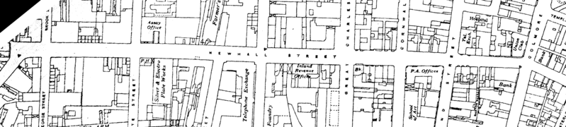
English: Newhall Street, Birmingham, England. Map from Ordnance Survey 4th edition, 1937. The map has been rotated 39 degrees anticlockwise.
In public domain in all countries because Ordnance Survey Crown Copyright lasts statutory 50 years. See Wikipedia:Copyrights#UK Crown Copyright, see also Statement from Office for Public Sector Information (was HMSO). |
| Date | 19 July 2006 (original upload date) |
| Source | Transferred from en.wikipedia to Commons. |
| Author | The original uploader was Oosoom at English Wikipedia. |
Licensing[edit]
This work is an Ordnance Survey map over 50 years old, which is covered by Crown Copyright which in this case expires 50 years after publication. Ordnance Survey does however ask that they be credited and that the date of publication be given.
Any ancillary rights gained through the creation of the electronic version are granted as freely usable under any circumstances.
|
This work created by the United Kingdom Government is in the public domain.
This is because it is one of the following:
HMSO has declared that the expiry of Crown Copyrights applies worldwide (ref: HMSO Email Reply)
|
 |
Original upload log[edit]
The original description page was here. All following user names refer to en.wikipedia.
- 2006-07-19 09:27 Oosoom 8449×1905× (338674 bytes) [[Newhall Street]], Birmingham, England. Map from Ordnance Survey 4st edition, 1937. The map has been rotated 39 degrees anticlockwise. In public domain in all countries because Ordnance Survey Crown Copyright lasts statutory 50 years. See ''[[Wikipedia:
File history
Click on a date/time to view the file as it appeared at that time.
| Date/Time | Thumbnail | Dimensions | User | Comment | |
|---|---|---|---|---|---|
| current | 19:02, 5 August 2010 | 8,449 × 1,905 (331 KB) | Oosoom (talk | contribs) | {{Information |Description={{en|Newhall Street, Birmingham, England. Map from Ordnance Survey 4th edition, 1937. The map has been rotated 39 degrees anticlockwise. In public domain in all countries because Ordnance Survey Crown Cop |
You cannot overwrite this file.
File usage on Commons
There are no pages that use this file.
File usage on other wikis
The following other wikis use this file:
- Usage on en.wikipedia.org