File:New Silk Road - ru.svg
Jump to navigation
Jump to search

Size of this PNG preview of this SVG file: 800 × 441 pixels. Other resolutions: 320 × 176 pixels | 640 × 353 pixels | 1,024 × 564 pixels | 1,280 × 705 pixels | 2,560 × 1,411 pixels | 1,174 × 647 pixels.
Original file (SVG file, nominally 1,174 × 647 pixels, file size: 237 KB)
Captions
Captions
Add a one-line explanation of what this file represents
Summary[edit]
| Description |
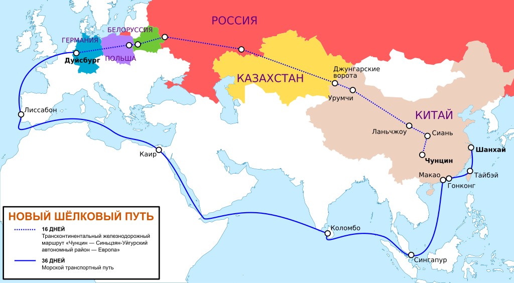
Русский: Сравнительное время прохождения грузов между Китаем и Европой по традиционному (водному) пути и по Новому Шёлковому пути (сухопутному) через Россию. Маршрут указан в соответствии с данными компании, которая со стороны Китая отвечает за транспортировку грузов.
Français : Comparaison des durées de transport entre la Chine et l'Europe par la route maritime habituelle et par la Nouvelle Route de la soie (par voie terrestre). L'itinéraire est celui fourni par le site de l'entreprise Youxinou Logistics.
Légende des toponymes (dans le sens horaire) :
Cartouche :
|
| Date | |
| Source |
 Own work based on File:Новый шёлковый путь.jpg Map: Natural Earth (public domain) edited with Mapthematics Geocart and vectorized with Inkscape; Mercator projection. |
| Author | Kaidor |
| SVG development | This vector image was created with Inkscape, or with something else. |

|
This SVG file contains embedded text that can be translated into your language, using any capable SVG editor, text editor or the SVG Translate tool. For more information see: About translating SVG files. |
Licensing[edit]
I, the copyright holder of this work, hereby publish it under the following license:
This file is licensed under the Creative Commons Attribution-Share Alike 4.0 International license.
- You are free:
- to share – to copy, distribute and transmit the work
- to remix – to adapt the work
- Under the following conditions:
- attribution – You must give appropriate credit, provide a link to the license, and indicate if changes were made. You may do so in any reasonable manner, but not in any way that suggests the licensor endorses you or your use.
- share alike – If you remix, transform, or build upon the material, you must distribute your contributions under the same or compatible license as the original.
File history
Click on a date/time to view the file as it appeared at that time.
| Date/Time | Thumbnail | Dimensions | User | Comment | |
|---|---|---|---|---|---|
| current | 23:52, 16 September 2022 | | 1,174 × 647 (237 KB) | Kaidor (talk | contribs) | redrawn |
| 20:41, 25 October 2016 |  | 1,174 × 647 (237 KB) | Kaidor (talk | contribs) | Текст в кривые | |
| 21:21, 24 October 2016 |  | 1,174 × 647 (113 KB) | Kaidor (talk | contribs) | User created page with UploadWizard |
You cannot overwrite this file.
File usage on Commons
The following 9 pages use this file:
- User:Chumwa/OgreBot/Potential transport maps/2016 October 21-31
- User:Chumwa/OgreBot/Public transport information/2016 October 21-31
- User:Chumwa/OgreBot/Public transport information/2022 September 11-20
- User:Chumwa/OgreBot/Transport Maps/2016 October 21-31
- User:Chumwa/OgreBot/Transport Maps/2022 September 11-20
- User:Chumwa/OgreBot/Travel and communication maps/2016 October 21-31
- User:Chumwa/OgreBot/Travel and communication maps/2022 September 11-20
- User:Kaidor
- User:Magog the Ogre/Multilingual legend/2022 September 11-20
File usage on other wikis
The following other wikis use this file:
- Usage on fr.wikipedia.org
- Usage on kk.wikipedia.org
- Usage on mn.wikipedia.org
- Usage on ru.wikipedia.org