File:NederlandProvincie.jpg
Jump to navigation
Jump to search

No higher resolution available.
NederlandProvincie.jpg (462 × 568 pixels, file size: 90 KB, MIME type: image/jpeg)
Captions
Captions
Add a one-line explanation of what this file represents
Summary[edit]
| Description |
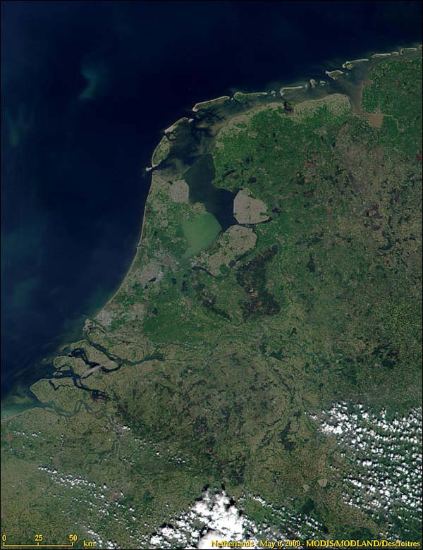
Nederlands: Nederland en de indeling in provincies.
Samengesteld door Ed Stevenhagen 13 jul 2005 17:14 (CEST) Satellietopname: Nederland uit de ruimte van modis.gsfc.nasa.gov/MODIS/IMAGE_GALLERY/MODIS1000097_md.jpg NASA Terms of Use For all non-private uses, NASA's Terms Of Use are as follows:
Visible Earth Addendum Beyond the NASA Terms, the Visible Earth team requests, but does not require:
|
| Date | 13 July 2005 (original upload date) |
| Source | Transferred from nl.wikipedia |
| Author | Original uploader was Ed Stevenhagen at nl.wikipedia |
| Permission (Reusing this file) |
This image is in the public domain; PD-NASA. |
Licensing[edit]
| This file is in the public domain in the United States because it was solely created by NASA. NASA copyright policy states that "NASA material is not protected by copyright unless noted". (See Template:PD-USGov, NASA copyright policy page or JPL Image Use Policy.) | ||
 |
Warnings:
|

|
Textual information (e.g. timestamp) once visible in the image itself has been moved into the image metadata and/or image description page. This makes the image easier to reuse and more language-neutral, and makes the text easier to process and search for. Commons discourages placing visible textual information in images. All licenses accepted on Commons permit this type of modification as a derivative work.
If attribution information were removed and the image is not public domain, replace this tag with {{Attribution metadata from licensed image}}.
|
Original upload log[edit]
The original description page was here. All following user names refer to nl.wikipedia.
- 2006-01-22 22:39 Ed Stevenhagen 462×568×8 (74968 bytes) Zie oorspronkelijke beschrijving. Aanpassing Markerwaard
- 2005-07-13 15:14 Ed Stevenhagen 462×568×8 (168190 bytes) Nederland en de indeling in provincies. Samengesteld door ~~~~ Satellietopname: Nederland uit de ruimte van [http://modis.gsfc.nasa.gov/MODIS/IMAGE_GALLERY/MODIS1000097_md.jpg modis.gsfc.nasa.gov/MODIS/IMAGE_GALLERY/MODIS1000097_md.jpg] NASA Terms of Use
File history
Click on a date/time to view the file as it appeared at that time.
| Date/Time | Thumbnail | Dimensions | User | Comment | |
|---|---|---|---|---|---|
| current | 03:24, 4 August 2008 | | 462 × 568 (90 KB) | Jarekt (talk | contribs) | Removed 4 watermarks |
| 05:02, 3 August 2008 |  | 462 × 546 (74 KB) | Jarekt (talk | contribs) | {{Information |Description=removed watermark |Source= |Date= |Author= |Permission= |other_versions= }} | |
| 08:30, 6 March 2008 |  | 462 × 568 (73 KB) | File Upload Bot (Magnus Manske) (talk | contribs) | {{BotMoveToCommons|nl.wikipedia}} {{Information |Description={{nl|Nederland en de indeling in provincies. Samengesteld door Ed Stevenhagen 13 jul 2005 17:14 (CEST) Satellietopname: Nederland uit de ruimte van [http://modi |
You cannot overwrite this file.
File usage on Commons
There are no pages that use this file.
File usage on other wikis
The following other wikis use this file:
- Usage on nl.wikipedia.org
- Usage on zh.wiktionary.org