File:Nebraska Highway 10.png
Jump to navigation
Jump to search

Size of this preview: 800 × 474 pixels. Other resolutions: 320 × 190 pixels | 640 × 380 pixels | 1,024 × 607 pixels | 1,280 × 759 pixels | 3,425 × 2,031 pixels.
Original file (3,425 × 2,031 pixels, file size: 899 KB, MIME type: image/png)
Captions
Captions
Add a one-line explanation of what this file represents
Summary[edit]
| Description |
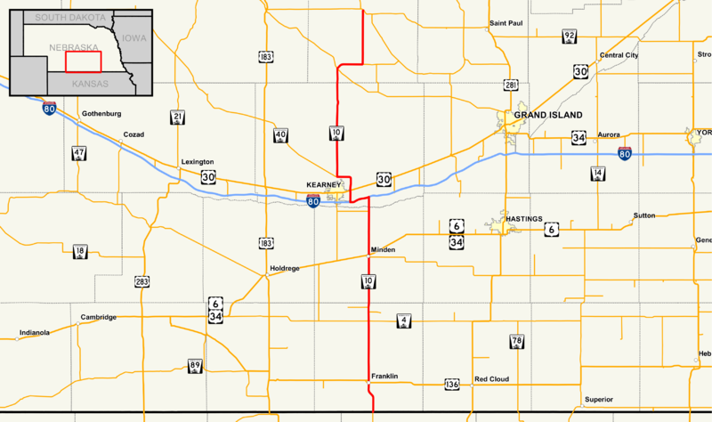
English: Map of Nebraska Highway 10
Data Sources:
|
|||
| Date | ||||
| Source | Own work | |||
| Author | Stratosphere | |||
| Permission (Reusing this file) |
I, the copyright holder of this work, hereby publish it under the following license:
|
File history
Click on a date/time to view the file as it appeared at that time.
| Date/Time | Thumbnail | Dimensions | User | Comment | |
|---|---|---|---|---|---|
| current | 04:18, 30 December 2016 | | 3,425 × 2,031 (899 KB) | Stratosphere (talk | contribs) | Nebraska Highway 10 was relocated north and east of Kearney to the exit 275 interchange |
| 05:00, 27 December 2016 |  | 3,425 × 2,031 (1.46 MB) | Stratosphere (talk | contribs) |
You cannot overwrite this file.
File usage on Commons
The following 5 pages use this file:
File usage on other wikis
The following other wikis use this file:
- Usage on en.wikipedia.org
- Usage on www.wikidata.org