File:Nawchey kellaterzan Sorani.svg
Jump to navigation
Jump to search

Size of this PNG preview of this SVG file: 413 × 493 pixels. Other resolutions: 201 × 240 pixels | 402 × 480 pixels | 643 × 768 pixels | 858 × 1,024 pixels | 1,716 × 2,048 pixels.
Original file (SVG file, nominally 413 × 493 pixels, file size: 237 KB)
Captions
Captions
Add a one-line explanation of what this file represents
Summary[edit]
| Description |
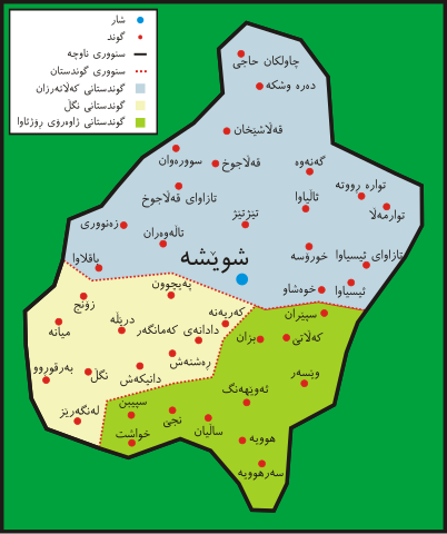
English: Kalatarzan map (A region in the county of Sna (Sanandaj), west of Iran)
Kurdî: نەخشەی کەڵاتەرزان (ناوچەیەک سەر بە شارستانی سنە)
فارسی: نقشه کلاترزان (یکی از بخشهای شهرستان سنندج) |
| Date | |
| Source | Own work |
| Author | Ferhad y |
Licensing[edit]
| I, the copyright holder of this work, release this work into the public domain. This applies worldwide. In some countries this may not be legally possible; if so: I grant anyone the right to use this work for any purpose, without any conditions, unless such conditions are required by law. |
File history
Click on a date/time to view the file as it appeared at that time.
| Date/Time | Thumbnail | Dimensions | User | Comment | |
|---|---|---|---|---|---|
| current | 16:12, 20 August 2009 | | 413 × 493 (237 KB) | Ferhad y (talk | contribs) | {{Information |Description={{en|1=Kalatarzan map (A region in the county of Sna (Sanandaj), west of Iran)}} {{ku|1=نەخشەی کەڵاتەرزان (ناوچەیەک سەر بە شارستانی سنە)}} {{fa|1=نقشه کلاترزان (یکی از ب� |
You cannot overwrite this file.
File usage on Commons
The following page uses this file: