File:Nawatlahtolli pan tlaltepaktli.svg
Jump to navigation
Jump to search

Size of this PNG preview of this SVG file: 800 × 382 pixels. Other resolutions: 320 × 153 pixels | 640 × 306 pixels | 1,024 × 489 pixels | 1,280 × 611 pixels | 2,560 × 1,223 pixels | 2,437 × 1,164 pixels.
Original file (SVG file, nominally 2,437 × 1,164 pixels, file size: 947 KB)
Captions
Captions
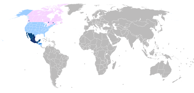
Nahuan languages global world map
Summary
[edit]
| Description |
Català: Mapa mundial de la llengua nàhuatl.
Descripció: Estats de Mèxic on més de 10 000 habitants parlen nàhuatl
Estats de Mèxic on menys de 10 000 habitants parlen nàhuatl
Països on es parla una llengua nahua, però no és idioma oficial
Altres països on hi ha comunitats de nahuatlats Deutsch: Weltkarte der Nahuatl Sprachen.
Beschreibung: Staaten von Mexiko, in denen mehr als 10 000 Einwohner die Nahuatl sprechen
Staaten von Mexiko, in denen weniger als 10 000 Einwohner die Nahuatl sprechen
Länder, in denen Nahuatl gesprochen wird, aber keine Amtssprache ist
Andere Länder, in denen es Nahuatl sprechende Gemeinschaften gibt Ελληνικά: Παγκόσμιος χάρτης των γλωσσών νάουατλ.
Περιγραφή: Πολιτεία του Μεξικού όπου περισσότεροι από 10.000 άνθρωποι μιλούν νάουατλ
Πολιτεία του Μεξικού όπου λιγότεροι από 10.000 άνθρωποι μιλούν νάουατλ
Χώρες όπου ομιλείται μια γλώσσα νάουατλ, αλλά δεν είναι επίσημη γλώσσα
Άλλες χώρες όπου υπάρχουν κοινότητες που μιλούν νάουατλ English: World map of the Nahuan languages.
Description: States of Mexico where more than 10 000 people speak Nahuatl
States of Mexico where less than 10 000 people speak Nahuatl
Countries where a Nahuan language is spoken, but it's not an official language
Other countries where Nahuatl speaking communities exist Español: Mapa mundial sobre las lenguas nahuas.
Descripción: Estados mexicanos en los que más de 10 000 habitantes hablan náhuatl
Estados mexicanos en los que menos de 10 000 habitantes hablan náhuatl
Países donde se habla una lengua nahua, pero no es idioma oficial
Otros países donde existen comunidades de nahuatlatos Euskara: Munduko mapa nahua hizkuntzei buruz.
Deskribapena: Mexikoko estatuak, non 10 000 pertsona baino gehiagok nahuatl hitz egiten duten
Mexikoko estatuak, non 10 000 pertsona baino gutxiagok nahuatl hitz egiten duten
Nahuatl hizkuntza bat hitz egiten den, baina hizkuntza ofiziala ez den herrialdeak
Nahuatl hiztun komunitateak dauden beste herrialde batzuk Français : Carte du mond des langues nahuatl.
Description: États du Mexique où plus de 10 000 habitants parlent le nahuatl
États du Mexique où moins de 10 000 habitants parlent le nahuatl
Pays où une langue nahuatl est parlée, mais ce n'est pas une langue officielle
Autres pays où existent des communautés de langue nahuatl Italiano: Mappa del mondo della lingua nahuatl.
Descrizione: Stati del Messico dove più di 10 000 persone parlano nahuatl
Stati del Messico dove meno di 10 000 persone parlano nahuatl
Paesi in cui si parla una lingua nahua, ma non è una lingua ufficiale
Altri paesi in cui esistono comunità di lingua nahuatl Nāhuatl: Tlalixneskayotl tlen mexikatlahtolli.
Tlayolmelawalistli: Tlatilantli tlen Mexko kanpa achiyok tlen 10 000 masewalmeh nawatih
Tlatilantli tlen Mexko kanpa kentsin tlen 10 000 masewalmeh nawatih
Wexteyowalli kanpa mosaniloa nawatl, sanpanpa axkanah itekpantlahtol
Sekinok wexteyowaltinih kanpa onkah nawatlahtohkateyowalli Polski: Mapa świata języków nawatl.
Opis: Stany Meksyku, w których ponad 10 000 osób mówi w nawatl
Stany Meksyku, w których mniej niż 10 000 osób mówi w nawatl
Kraje, w których używany jest język nawatl, ale nie jest to język urzędowy
Inne kraje, w których istnieją społeczności mówiące w języku nawatl Português: Mapa mundial das línguas nahuanas.
Descrição: Estados do México onde mais de 10 000 pessoas falam náuatle
Estados do México onde menos de 10 000 pessoas falam náuatle
Países onde o náuatle é falado, mas não é um idioma oficial
Outros países onde existem comunidades de língua náuatle Русский: Карта мира языков науатԓ.
Описание: Штаты Мексики, где более 10 000 жителей говорят на науатԓ
Штаты Мексики, где менее 10 000 жителей говорят на науатԓ
Страны, в которых говорят на науанском языке, но он не является официальным языком
Другие страны, где существуют общины, говорящие на языке науатԓ Kiswahili: Ramani ya ulimwengu ya lugha za Kinawatl.
Maelezo: Majimbo ya Meksiko ambako zaidi ya watu 10 000 wanazungumza Kinawatl
Majimbo ya Meksiko ambako chini ya watu 10 000 wanazungumza Kinawatl
Nchi ambako lugha ya Kinawatl inazungumzwa, lakini si lugha rasmi
Nchi zingine ambapo jumuiya zinazozungumza Kinahuatl zipo Tagalog: Mapa ng mundo ng wikang Nawatl. Paglalarawan: Mga Estado ng Mehiko kung saan mahigit 10 000 tao ang nagsasalita ng Nawatl
Mga Estado ng Mehiko kung saan wala pang 10 000 katao ang nagsasalita ng Nawatl
Mga bansa kung saan ginagamit ang wikang Nawatl, ngunit hindi ito opisyal na wika
Iba pang mga bansa kung saan umiiral ang mga komunidad na nagsasalita ng Nawatl |
| Date | |
| Source | Own work |
| Author | Languaeditor |
Licensing
[edit]
I, the copyright holder of this work, hereby publish it under the following license:
This file is licensed under the Creative Commons Attribution-Share Alike 4.0 International license.
- You are free:
- to share – to copy, distribute and transmit the work
- to remix – to adapt the work
- Under the following conditions:
- attribution – You must give appropriate credit, provide a link to the license, and indicate if changes were made. You may do so in any reasonable manner, but not in any way that suggests the licensor endorses you or your use.
- share alike – If you remix, transform, or build upon the material, you must distribute your contributions under the same or compatible license as the original.
File history
Click on a date/time to view the file as it appeared at that time.
| Date/Time | Thumbnail | Dimensions | User | Comment | |
|---|---|---|---|---|---|
| current | 14:17, 2 January 2023 | | 2,437 × 1,164 (947 KB) | Languaeditor (talk | contribs) | Uploaded own work with UploadWizard |
You cannot overwrite this file.
File usage on Commons
The following 5 pages use this file:
- User:Chumwa/OgreBot/Travel and communication maps/2021 December 11-20
- User:Chumwa/OgreBot/Travel and communication maps/2021 November 21-30
- User:Chumwa/OgreBot/Travel and communication maps/2022 October 21-31
- User:Chumwa/OgreBot/Travel and communication maps/2023 January 1-10
- User:Magog the Ogre/Multilingual legend/2021 November 21-30
File usage on other wikis
The following other wikis use this file:
- Usage on af.wikipedia.org
- Usage on en.wikipedia.org
- Usage on es.wikipedia.org
- Usage on gl.wikipedia.org
- Usage on nah.wikipedia.org