File:Naddniestrze-administracja.png
Jump to navigation
Jump to search

Size of this preview: 408 × 599 pixels. Other resolutions: 163 × 240 pixels | 327 × 480 pixels | 922 × 1,354 pixels.
Original file (922 × 1,354 pixels, file size: 155 KB, MIME type: image/png)
Captions
Captions
Add a one-line explanation of what this file represents
Summary[edit]
| Description |
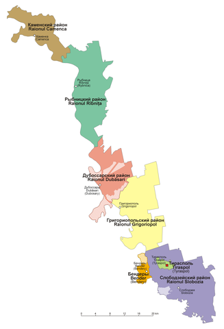
English: Administrative divisions of Pridnestrovie
Polski: Mapa administracyjna Naddniestrza |
| Date | |
| Source | Own work |
| Author | Aotearoa |
Licensing[edit]
I, the copyright holder of this work, hereby publish it under the following licenses:

|
Permission is granted to copy, distribute and/or modify this document under the terms of the GNU Free Documentation License, Version 1.2 or any later version published by the Free Software Foundation; with no Invariant Sections, no Front-Cover Texts, and no Back-Cover Texts. A copy of the license is included in the section entitled GNU Free Documentation License. |
| This file is licensed under the Creative Commons Attribution-Share Alike 3.0 Unported license. | ||
| ||
| This licensing tag was added to this file as part of the GFDL licensing update. |
You may select the license of your choice.
File history
Click on a date/time to view the file as it appeared at that time.
| Date/Time | Thumbnail | Dimensions | User | Comment | |
|---|---|---|---|---|---|
| current | 08:27, 28 March 2019 | | 922 × 1,354 (155 KB) | Aotearoa (talk | contribs) | Reverted to version as of 14:08, 3 August 2015 (UTC) - incorrect text |
| 19:33, 13 August 2017 |  | 922 × 1,354 (59 KB) | MAXHO (talk | contribs) | Correction according with all sources and travellers, with NordNordWest's map [https://commons.wikimedia.org/wiki/File:Moldova_location_map.svg], with Aotearoa's original maps [https://commons.wikimedia.org/wiki/File:Naddniestrze.png], [https://common... | |
| 17:14, 23 February 2017 |  | 922 × 1,354 (43 KB) | Nicolay Sidorov (talk | contribs) | de-facto borders | |
| 14:08, 3 August 2015 |  | 922 × 1,354 (155 KB) | Aotearoa (talk | contribs) | Reverted to version as of 20:17, 26 August 2008 - this is map in Polish, English text might be added in duplicated file | |
| 17:02, 2 August 2015 |  | 922 × 1,354 (171 KB) | Spiridon Ion Cepleanu (talk | contribs) | Legend of the striped areas | |
| 20:17, 26 August 2008 |  | 922 × 1,354 (155 KB) | Aotearoa (talk | contribs) | {{Information |Description={{en|1=Administrative divisions of Transnistria}} {{pl|1=Mapa administracyjna Naddniestrza}} |Source=Praca własna osoby przesyłającej (own work by uploader) |Author=Aotearoa |Date=26.08.2008 |Permission= |ot |
You cannot overwrite this file.
File usage on Commons
The following 5 pages use this file:
.png)
File usage on other wikis
The following other wikis use this file:
- Usage on ca.wikipedia.org
- Usage on csb.wikipedia.org
- Usage on de.wikipedia.org
- Usage on gag.wikipedia.org
- Usage on pl.wikipedia.org
- Usage on pl.wikivoyage.org
- Usage on ru.wikipedia.org
- Usage on tr.wikipedia.org
- Usage on uk.wikipedia.org