File:NWFB08PRtMap.png
Jump to navigation
Jump to search
Size of this preview: 800 × 357 pixels. Other resolutions: 320 × 143 pixels | 640 × 286 pixels | 1,024 × 457 pixels | 1,280 × 572 pixels | 3,663 × 1,636 pixels.
Original file (3,663 × 1,636 pixels, file size: 674 KB, MIME type: image/png)
Captions
Captions
Add a one-line explanation of what this file represents
Summary[edit]
| Description |
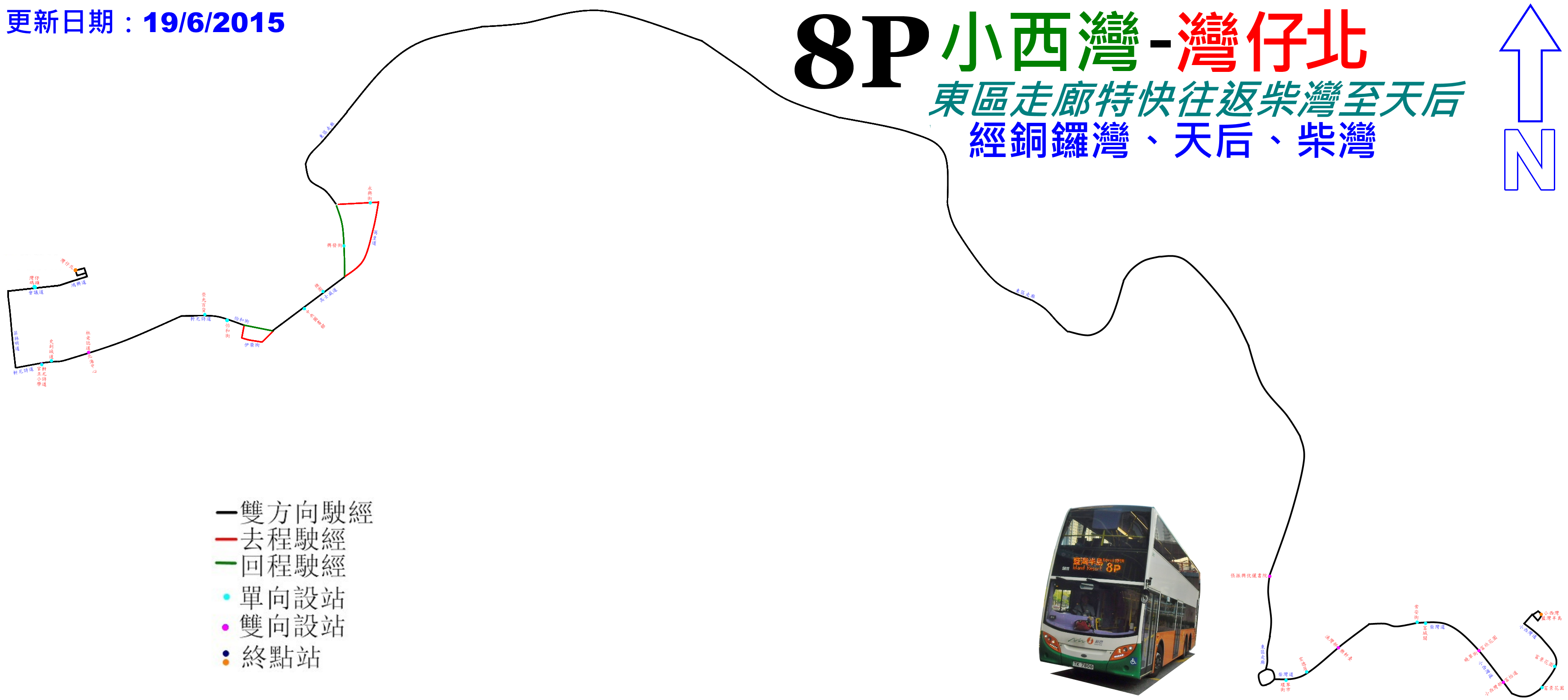
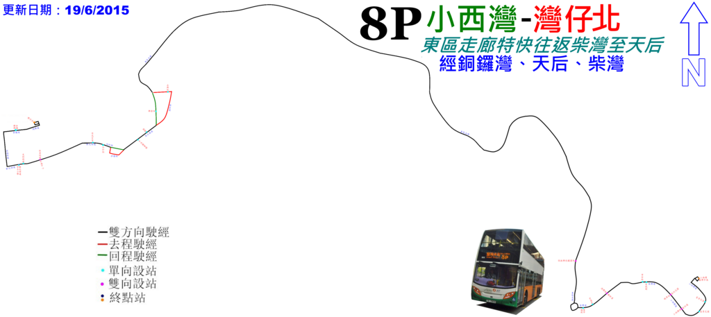
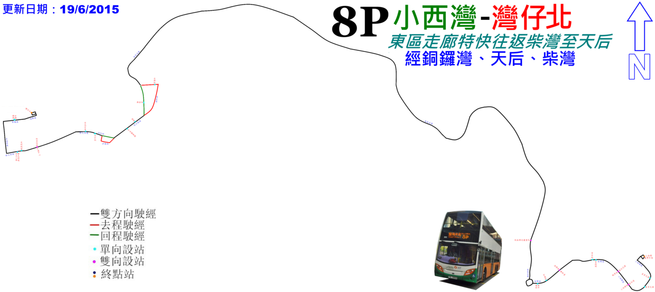
中文(香港):新巴8P線的走線圖 |
| Date | |
| Source | Own work |
| Author | ATR50 |
Licensing[edit]
I, the copyright holder of this work, hereby publish it under the following license:
This file is licensed under the Creative Commons Attribution-Share Alike 3.0 Unported license.
- You are free:
- to share – to copy, distribute and transmit the work
- to remix – to adapt the work
- Under the following conditions:
- attribution – You must give appropriate credit, provide a link to the license, and indicate if changes were made. You may do so in any reasonable manner, but not in any way that suggests the licensor endorses you or your use.
- share alike – If you remix, transform, or build upon the material, you must distribute your contributions under the same or compatible license as the original.
File history
Click on a date/time to view the file as it appeared at that time.
| Date/Time | Thumbnail | Dimensions | User | Comment | |
|---|---|---|---|---|---|
| current | 15:31, 4 July 2016 | | 3,663 × 1,636 (674 KB) | ATR50~commonswiki (talk | contribs) | 2016年7月換圖 |
| 16:10, 19 June 2015 |  | 3,663 × 1,636 (689 KB) | ATR50~commonswiki (talk | contribs) | 2015年5月由灣仔碼頭搬至灣仔北 | |
| 16:09, 19 June 2015 |  | 3,259 × 1,636 (622 KB) | ATR50~commonswiki (talk | contribs) | 2015年5月由灣仔碼頭搬至灣仔北 | |
| 03:08, 30 May 2014 |  | 3,663 × 1,636 (642 KB) | ATR50~commonswiki (talk | contribs) | User created page with UploadWizard |
You cannot overwrite this file.
File usage on Commons
The following 11 pages use this file:
- User:Aschroet/Uploads/Thuringia/2015 June 11-20
- User:Chumwa/OgreBot/Potential transport maps/2016 July 1-10
- User:Chumwa/OgreBot/Public transport information/2015 June 11-20
- User:Chumwa/OgreBot/Public transport information/2016 July 1-10
- User:Chumwa/OgreBot/Transport Maps/2015 June 11-20
- User:Chumwa/OgreBot/Transport Maps/2016 July 1-10
- User:Chumwa/OgreBot/Travel and communication maps/2016 July 1-10
- User:Indeedous/Recent Uploads/Namibia/2015-Q2
- User:OgreBot/Watercraft/2016 July 1-4
- User:Pechristener/Bridges/2014 May 21-31
- User:Pechristener/Bridges/2015 June 11-20
File usage on other wikis
The following other wikis use this file:
- Usage on zh.wikipedia.org