File:NRHP Arizona Map.svg
Jump to navigation
Jump to search

Size of this PNG preview of this SVG file: 776 × 600 pixels. Other resolutions: 311 × 240 pixels | 621 × 480 pixels | 994 × 768 pixels | 1,280 × 989 pixels | 2,560 × 1,978 pixels | 990 × 765 pixels.
Original file (SVG file, nominally 990 × 765 pixels, file size: 5.91 MB)
Captions
Captions
Add a one-line explanation of what this file represents
Summary[edit]
| Description |
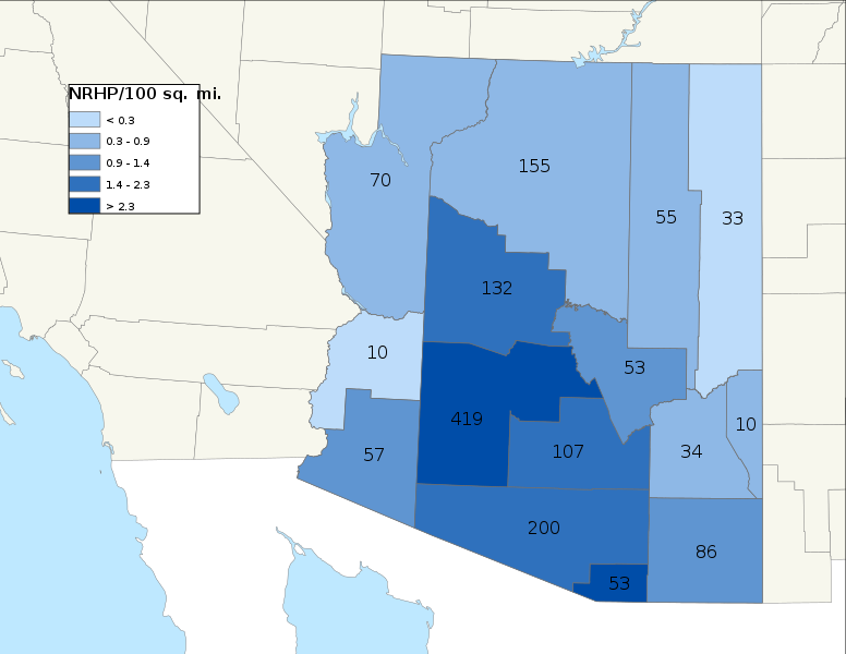
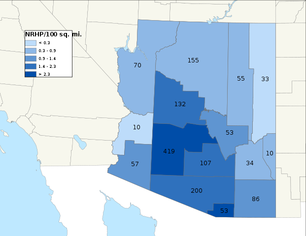
English: Map of the density of National Register of Historic Places in Arizona|.
|
||
| Date | |||
| Source | Own work | ||
| Author | 25or6to4 |
Licensing[edit]
I, the copyright holder of this work, hereby publish it under the following licenses:
This file is licensed under the Creative Commons Attribution-Share Alike 3.0 Unported license.
- You are free:
- to share – to copy, distribute and transmit the work
- to remix – to adapt the work
- Under the following conditions:
- attribution – You must give appropriate credit, provide a link to the license, and indicate if changes were made. You may do so in any reasonable manner, but not in any way that suggests the licensor endorses you or your use.
- share alike – If you remix, transform, or build upon the material, you must distribute your contributions under the same or compatible license as the original.

|
Permission is granted to copy, distribute and/or modify this document under the terms of the GNU Free Documentation License, Version 1.2 or any later version published by the Free Software Foundation; with no Invariant Sections, no Front-Cover Texts, and no Back-Cover Texts. A copy of the license is included in the section entitled GNU Free Documentation License. |
You may select the license of your choice.
File history
Click on a date/time to view the file as it appeared at that time.
| Date/Time | Thumbnail | Dimensions | User | Comment | |
|---|---|---|---|---|---|
| current | 09:21, 9 April 2022 | | 990 × 765 (5.91 MB) | 25or6to4 (talk | contribs) | NRHP counts thru March 2022 |
| 01:58, 11 March 2019 |  | 990 × 765 (2.63 MB) | 25or6to4 (talk | contribs) | Updated through March 1, 2019. | |
| 17:14, 3 April 2016 |  | 792 × 612 (868 KB) | 25or6to4 (talk | contribs) | Updated through January 1, 2016 | |
| 05:16, 9 September 2014 |  | 792 × 612 (866 KB) | 25or6to4 (talk | contribs) | Updated through September 2014 | |
| 06:45, 16 September 2012 |  | 792 × 612 (317 KB) | 25or6to4 (talk | contribs) | updated through August 2012 | |
| 11:30, 16 December 2009 |  | 792 × 612 (243 KB) | 25or6to4 (talk | contribs) | updated through 12/04/09 | |
| 20:40, 30 May 2009 |  | 612 × 792 (195 KB) | 25or6to4 (talk | contribs) | {{Information |Description={{en|1=Map of NRHP density in Arizona}} |Source=Own work by uploader |Author=25or6to4 |Date=5/30/09 |Permission= |other_versions= }} <!--{{ImageUpload|full}}--> Category:Maps of Arizona [[Category:National |
You cannot overwrite this file.
File usage on Commons
There are no pages that use this file.
File usage on other wikis
The following other wikis use this file:
- Usage on de.wikipedia.org
- Usage on pt.wikipedia.org
- Usage on ro.wikipedia.org
- Scottsdale, Arizona
- Avondale, Arizona
- Phoenix, Arizona
- Categorie:Phoenix, Arizona
- Listă de localități din Arizona, SUA
- Categorie:Statul Arizona, SUA
- Arizona
- Arizona (dezambiguizare)
- Format:Arizona stat SUA
- Listă de guvernatori ai statului Arizona, Statele Unite ale Americii
- Listă de comitate din statul Arizona
- New Mexico (teritoriu SUA)
- Northern Arizona University
- Arizona (teritoriu SUA)
- Arizona (teritoriu SCA)
- Grand Canyon
- Listă de parcuri de stat din statul Arizona
- Prefix telefonic 928 (Statele Unite ale Americii)
- Deșertul Sonora
- Listă de orașe din statul Arizona
- Flagstaff, Arizona
- Drapelul Arizonei
- Mesa, Arizona
- Chandler, Arizona
- Deșertul Mojave
- Comitatul Santa Cruz, Arizona
- Categorie:Comitatul Santa Cruz, Arizona
- Prefix telefonic 602 (Statele Unite ale Americii)
- Munții Santa Rita
- Categorie:Comitatul Maricopa, Arizona
- Madrean Sky Islands
- Lista grupelor montane ce formează Madrean Sky Islands
- Categorie:Madrean Sky Islands
- Categorie:Regiuni ale statului Arizona
- Mount Hopkins (Arizona)
- Categorie:Membri ai Senatului SUA din statul Arizona
- Listă de senatori ai Senatului Statelor Unite ale Americii din statul Arizona
- Vârful Humphreys
- Categorie:Liste Arizona
- Comitatul Coconino, Arizona
- Categorie:Comitatul Coconino, Arizona
- Comitatul Maricopa, Arizona
- Comitatul Pinal, Arizona
- Categorie:Comitatul Pinal, Arizona
- Categorie:Prefixe telefonice în Arizona
- Categorie:Geografia statului Arizona
- Listă de reprezentativi ai Camerei Reprezentanților SUA din teritoriul Arizona
- Munții Baboquivari
View more global usage of this file.