File:NPS lake-clark-chinitna-bay-map.jpg
Jump to navigation
Jump to search

No higher resolution available.
NPS_lake-clark-chinitna-bay-map.jpg (761 × 481 pixels, file size: 102 KB, MIME type: image/jpeg)
Captions
Captions
Add a one-line explanation of what this file represents
Summary[edit]
| Description |
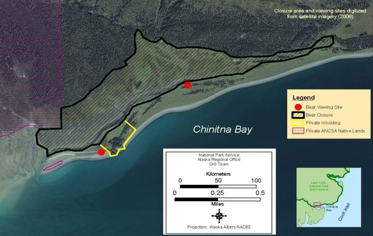
English: Alternate Chinitna Bay map made from satellite imagery. This one doesn’t show the access trail from the beach, but it does show an additional bear viewing area not on the map above. |
| Date | |
| Source | U.S. National Park Service (http://npmaps.com/wp-content/uploads/lake-clark-chinitna-bay-map.jpg) |
| Author | U.S. National Park Service, restoration/cleanup by Matt Holly |
Licensing[edit]
| This image or media file contains material based on a work of a National Park Service employee, created as part of that person's official duties. As a work of the U.S. federal government, such work is in the public domain in the United States. See the NPS website and NPS copyright policy for more information. |
File history
Click on a date/time to view the file as it appeared at that time.
| Date/Time | Thumbnail | Dimensions | User | Comment | |
|---|---|---|---|---|---|
| current | 00:39, 17 May 2017 | | 761 × 481 (102 KB) | RKBot (talk | contribs) | =={{int:filedesc}}== {{Information |description= {{en|1=Alternate Chinitna Bay map made from satellite imagery. This one doesn’t show the access trail from the beach, but it does show an additional bear viewing area not on the map above.}} |date= 201... |
You cannot overwrite this file.
File usage on Commons
The following 2 pages use this file: