File:NPS denali-park-road-map.jpg
Jump to navigation
Jump to search

Size of this preview: 800 × 528 pixels. Other resolutions: 320 × 211 pixels | 640 × 422 pixels | 900 × 594 pixels.
Original file (900 × 594 pixels, file size: 136 KB, MIME type: image/jpeg)
Captions
Captions
Add a one-line explanation of what this file represents
Summary[edit]
| Description |
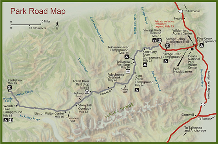
English: Denali Park Road map, showing campgrounds and points of interest along the 89 miles to Wonder Lake and Kantishna. It also shows which parts you can drive and which are shuttle bus only. |
| Date | |
| Source | U.S. National Park Service (http://npmaps.com/wp-content/uploads/denali-park-road-map.jpg) |
| Author | U.S. National Park Service, restoration/cleanup by Matt Holly |
Licensing[edit]
| This image or media file contains material based on a work of a National Park Service employee, created as part of that person's official duties. As a work of the U.S. federal government, such work is in the public domain in the United States. See the NPS website and NPS copyright policy for more information. |
File history
Click on a date/time to view the file as it appeared at that time.
| Date/Time | Thumbnail | Dimensions | User | Comment | |
|---|---|---|---|---|---|
| current | 21:04, 16 May 2017 | | 900 × 594 (136 KB) | RKBot (talk | contribs) | =={{int:filedesc}}== {{Information |description= {{en|1=Denali Park Road map, showing campgrounds and points of interest along the 89 miles to Wonder Lake and Kantishna. It also shows which parts you can drive and which are shuttle bus only.}} |date= 2... |
You cannot overwrite this file.
File usage on Commons
The following 2 pages use this file: