File:NASA Sees Fields of Green Spring up in Saudi Arabia (7027523783).jpg

Original file (2,050 × 1,405 pixels, file size: 1.65 MB, MIME type: image/jpeg)
Captions
Captions
Summary
[edit].jpg&action=edit§ion=1)
| Description |
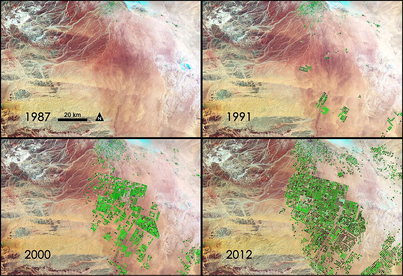
Saudi Arabia is drilling for a resource possibly more precious than oil. Over the last 24 years, it has tapped hidden reserves of water to grow wheat and other crops in the Syrian Desert. This time series of data shows images acquired by three different Landsat satellites operated by NASA and the U.S. Geological Survey. The green fields that dot the desert draw on water that in part was trapped during the last Ice Age. In addition to rainwater that fell over several hundred thousand years, this fossil water filled aquifers that are now buried deep under the desert's shifting sands. Saudi Arabia reaches these underground rivers and lakes by drilling through the desert floor, directly irrigating the fields with a circular sprinkler system. This technique is called center-pivot irrigation. Because rainfall in this area is now only a few centimeters (about one inch) each year, water here is a non-renewable resource. Although no one knows how much water is beneath the desert, hydrologists estimate it will only be economical to pump water for about 50 years. In this series of four Landsat images, the agricultural fields are about one kilometer (.62 miles) across. The images were created using reflected light from the short wave-infrared, near-infrared, and green portions of the electromagnetic spectrum (bands 7, 4, and 2 from Landsat 4 and 5 TM and Landsat 7 ETM+ sensors). Using this combination of wavelengths, healthy vegetation appears bright green while dry vegetation appears orange. Barren soil is a dark pink, and urban areas, like the town of Tubarjal at the top of each image, have a purple hue. Landsat 4 launched in 1982 and provided scientific data for 11 years until 1993. NASA launched Landsat 5 in 1984 and it ran a record-breaking 28 years, sending back what was likely its last data in 2011. Landsat 7 is still up and running; it was launched in 1999. The data from these and other Landsat satellites has been instrumental in increasing our understanding of forest health, storm damage, agricultural trends, urban growth, and many other ongoing changes to our land. NASA and the U.S. Department of the Interior through the U.S. Geological Survey (USGS) jointly manage Landsat, and the USGS preserves a 40-year archive of Landsat images that is freely available data over the Internet. The next Landsat satellite, now known as the Landsat Data Continuity Mission (LDCM) and later to be called Landsat 8, is scheduled for launch in January 2013. Credit: NASA/GSFC/Landsat NASA Goddard Space Flight Center enables NASA’s mission through four scientific endeavors: Earth Science, Heliophysics, Solar System Exploration, and Astrophysics. Goddard plays a leading role in NASA’s accomplishments by contributing compelling scientific knowledge to advance the Agency’s mission. Follow us on Twitter Like us on Facebook Find us on Instagram |
| Date | |
| Source | NASA Sees Fields of Green Spring up in Saudi Arabia |
| Author | NASA Goddard Space Flight Center from Greenbelt, MD, USA |
Licensing
[edit].jpg&action=edit§ion=2)
- You are free:
- to share – to copy, distribute and transmit the work
- to remix – to adapt the work
- Under the following conditions:
- attribution – You must give appropriate credit, provide a link to the license, and indicate if changes were made. You may do so in any reasonable manner, but not in any way that suggests the licensor endorses you or your use.
| This image was originally posted to Flickr by NASA Goddard Photo and Video at https://flickr.com/photos/24662369@N07/7027523783. It was reviewed on 17 September 2016 by FlickreviewR and was confirmed to be licensed under the terms of the cc-by-2.0. |
| This file is in the public domain in the United States because it was solely created by NASA. NASA copyright policy states that "NASA material is not protected by copyright unless noted". (See Template:PD-USGov, NASA copyright policy page or JPL Image Use Policy.) | ||
 |
Warnings:
|
File history
Click on a date/time to view the file as it appeared at that time.
| Date/Time | Thumbnail | Dimensions | User | Comment | |
|---|---|---|---|---|---|
| current | 21:47, 17 September 2016 | | 2,050 × 1,405 (1.65 MB) | Vanished Account Byeznhpyxeuztibuo (talk | contribs) | Transferred from Flickr via Flickr2Commons |
You cannot overwrite this file.
File usage on Commons
There are no pages that use this file.
.jpg&oldid=493809634)