File:Muttsee during construction time.jpg
Jump to navigation
Jump to search

Size of this preview: 799 × 240 pixels. Other resolutions: 640 × 192 pixels | 1,024 × 308 pixels | 1,280 × 385 pixels | 2,560 × 769 pixels | 7,968 × 2,394 pixels.
Original file (7,968 × 2,394 pixels, file size: 5.02 MB, MIME type: image/jpeg)
Captions
Captions
Add a one-line explanation of what this file represents
Summary
[edit]| Description |
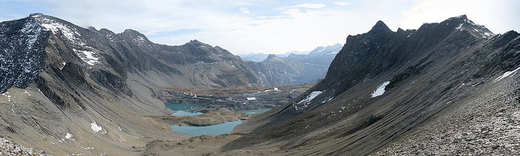
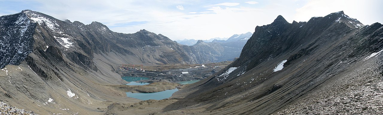
English: Muttsee during construction time of the dam, picture taken from north (150 m WSW of Scheidstöckli). Ruchi and Muttenstock on the left side, Nüschenstock and Rüchi on the right side. Panorama, Glarus Süd, Glarus, Switzerland
Deutsch: Muttsee während der Bauzeit des Staudamms der Kraftwerke Linth-Limmern AG, Bild aufgenommen von Norden (Grat zum Rüchi, 150 m WSW vom Scheidstöckli). Ruchi und Muttenstock auf der linken Seite, Nüschenstock und Rüchi auf der rechten Seite. Panorama, Glarus Süd, Glarus, Schweiz
Rumantsch: Muttsee durant igl taimp da construcziun digl rampar da Kraftwerke Linth-Limmern AG, igl maletg è nia piglia se digl feil tranter Rüchi e Scheidstöckli (150 m OSO digl Scheidstöckli). Ruchi e Muttenstock dalla vart sanester, Nüschenstock e Rüchi da mang dretg. Panorama, Glarus Süd, Glarus, Svizra
Italiano: Muttsee durante la construzione della diga di Kraftwerke Linth-Limmern AG, fotografato dalla cresta tra Rüchi e Scheidstöckli (150 m OSO dal Scheidstöckli). Ruchi e Muttenstock a sinistra, Nüschenstock e Rüchi a destra. Panorama, Glarus Süd, Glarus, Svizzera |
||
| Date | 28 September 2013, 16:10:00 | ||
| Source |
Own work
|
||
| Author | Martin Schumacher (uploader Capricorn4049) | ||
| Permission (Reusing this file) |

| Object location | | View this and other nearby images on: OpenStreetMap |
|---|
| Camera location | | View this and other nearby images on: OpenStreetMap |
|---|
Licensing
[edit]
I, the copyright holder of this work, hereby publish it under the following license:
This file is licensed under the Creative Commons Attribution-Share Alike 3.0 Germany license.
- You are free:
- to share – to copy, distribute and transmit the work
- to remix – to adapt the work
- Under the following conditions:
- attribution – You must give appropriate credit, provide a link to the license, and indicate if changes were made. You may do so in any reasonable manner, but not in any way that suggests the licensor endorses you or your use.
- share alike – If you remix, transform, or build upon the material, you must distribute your contributions under the same or compatible license as the original.

File history
Click on a date/time to view the file as it appeared at that time.
| Date/Time | Thumbnail | Dimensions | User | Comment | |
|---|---|---|---|---|---|
| current | 14:28, 13 November 2013 | 7,968 × 2,394 (5.02 MB) | Capricorn4049 (talk | contribs) | {{Information |description={{en|1=Muttsee during construction time of the dam, picture taken from north (150 m WSW of Scheidstöckli). Ruchi and Muttenstock on the left side, Nüschenstock and Rüchi on the right side, Glarus Süd, Glarus, Switzerland}... |
You cannot overwrite this file.
File usage on Commons
There are no pages that use this file.
File usage on other wikis
The following other wikis use this file:
- Usage on de.wikipedia.org