File:Musa Bay, Iran ESA372739.jpg

Original file (4,765 × 4,024 pixels, file size: 29.31 MB, MIME type: image/jpeg)
Captions
Captions
Summary[edit]
| Description |
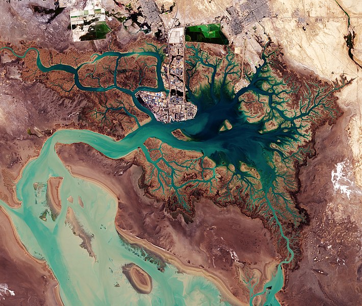
English: Iran’s Musa Bay (خور موسی) on the northern end of the Persian Gulf is pictured in this image from the Copernicus Sentinel-2A satellite on 13 January 2017.
Near the centre, we can see the port city of Bandar Imam Khomeini, situated at the terminus of the Trans-Iranian Railway – a route that links the Persian Gulf with Iran’s capital, Tehran. The dark area to the right of the port is Musa Bay, a shallow estuary. The large geometric structures along the top appear to be evaporation ponds for extracting naturally occurring minerals from the ground. The left side of the image is dominated by the marshes and mudflats of the Shadegan wildlife refuge. It is the largest wetland in Iran, and plays a significant role in the natural ecology of the area. The area provides a wintering habitat for a wide variety of migratory birds, and is the most important site in the world for a rare species of aquatic bird: the marbled duck. The northern part of the wetland is a vital freshwater habitat for many endangered species. This area is considered a wetland of international importance by the Ramsar Convention, an intergovernmental treaty for the sustainable use of wetlands. World Wetlands Day is observed every year on 2 February. This image is featured on the Earth from Space video programme. |
| Date | |
| Source | http://www.esa.int/spaceinimages/Images/2017/02/Musa_Bay_Iran |
| Author | European Space Agency |
| Permission (Reusing this file) |
contains modified Copernicus Sentinel data (2017), processed by ESA ,CC BY-SA 3.0 IGO |
| Other versions |
|
| Title | Musa Bay, Iran |
| Set | Earth observation image of the week |
| System | Copernicus |
| Mission | Sentinel-2 |
| Location | Iran |
| Activity | Observing the Earth |
| Keywords | Wetlands; Satellite image |

Assessment[edit]
|
Licensing[edit]
- You are free:
- to share – to copy, distribute and transmit the work
- to remix – to adapt the work
- Under the following conditions:
- attribution – You must give appropriate credit, provide a link to the license, and indicate if changes were made. You may do so in any reasonable manner, but not in any way that suggests the licensor endorses you or your use.
- share alike – If you remix, transform, or build upon the material, you must distribute your contributions under the same or compatible license as the original.
File history
Click on a date/time to view the file as it appeared at that time.
| Date/Time | Thumbnail | Dimensions | User | Comment | |
|---|---|---|---|---|---|
| current | 12:00, 14 January 2021 | | 4,765 × 4,024 (29.31 MB) | StellarHalo (talk | contribs) | higher resolution |
| 17:49, 6 May 2017 |  | 1,920 × 1,621 (3.54 MB) | Fæ (talk | contribs) | European Space Agency, Id 372739, http://www.esa.int/spaceinimages/Images/2017/02/Musa_Bay_Iran, User:Fæ/Project_list/ESA |
You cannot overwrite this file.
File usage on Commons
The following 16 pages use this file:
- User:Meiræ/21
- User talk:Fæ/2021
- User talk:StellarHalo
- Commons:Featured picture candidates/File:Musa Bay, Iran ESA372739.jpg
- Commons:Featured picture candidates/Log/February 2021
- Commons:Featured pictures/Places/Satellite images
- Commons:Featured pictures/chronological/2021-A
- Commons:Featured pictures/chronological/February 2021
- Commons:Picture of the Year/2021/Candidates
- Commons:Picture of the Year/2021/R1/Gallery/2021-A
- Commons:Picture of the Year/2021/R1/Gallery/ALL
- Commons:Picture of the Year/2021/R1/Gallery/Astronomy
- Commons:Picture of the Year/2021/R1/Gallery/M02
- Commons:Picture of the Year/2021/R1/v/Musa Bay, Iran ESA372739.jpg
- File:Musa Bay, Iran ESA372739.tiff
- Category:Musa Bay
File usage on other wikis
The following other wikis use this file:
- Usage on ar.wikipedia.org
- Usage on ceb.wikipedia.org
- Usage on en.wikipedia.org
- Usage on fa.wikipedia.org
- Usage on fr.wikipedia.org
- Usage on www.wikidata.org