File:Munich radar image 2009.jpg
Jump to navigation
Jump to search

Size of this preview: 267 × 598 pixels. Other resolutions: 107 × 240 pixels | 214 × 480 pixels | 342 × 768 pixels | 457 × 1,024 pixels | 913 × 2,048 pixels | 2,618 × 5,868 pixels.
Original file (2,618 × 5,868 pixels, file size: 11.38 MB, MIME type: image/jpeg)
Captions
Captions
Add a one-line explanation of what this file represents
Summary[edit]
| Description |
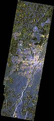
Polski: Radarowe zdjęcie Monachium i okolic. Wykonane 2 maja 2009 roku z rozdzielczością ok. 10 metrów na piksel.
Tereny zurbanizowane mają kolor w odcieniach czerwieni i żółci. Tereny rolnicze, odcienie zieleni. Tereny zalesione, odcienie niebieskiego. English: This image shows the urban region of Munich and the surrounding area. It was acquired on 2 May 2009 at a resolution of 10 metres. The urban area is depicted in shades of red and yellow, while agricultural land appears in shades of green with woodland and forest areas shown in shades of blue. This information can, for example, be used to produce land usage maps, as well as for town planning purposes. |
| Date | |
| Source | http://www.dlr.de/media/en/desktopdefault.aspx/tabid-4986/8423_read-13266/8423_page-2 |
| Author | DLR |
Licensing[edit]
This file is licensed under the Creative Commons Attribution 3.0 Unported license.
- You are free:
- to share – to copy, distribute and transmit the work
- to remix – to adapt the work
- Under the following conditions:
- attribution – You must give appropriate credit, provide a link to the license, and indicate if changes were made. You may do so in any reasonable manner, but not in any way that suggests the licensor endorses you or your use.
File history
Click on a date/time to view the file as it appeared at that time.
| Date/Time | Thumbnail | Dimensions | User | Comment | |
|---|---|---|---|---|---|
| current | 08:15, 14 June 2014 | | 2,618 × 5,868 (11.38 MB) | NH2501 (talk | contribs) | User created page with UploadWizard |
You cannot overwrite this file.
File usage on Commons
The following page uses this file: