File:Moyka river in Saint Petersburg view south from Pevchesky bridge.jpg
Jump to navigation
Jump to search

Size of this preview: 800 × 534 pixels. Other resolutions: 320 × 214 pixels | 640 × 427 pixels | 1,024 × 683 pixels | 1,280 × 854 pixels | 2,560 × 1,709 pixels | 7,360 × 4,912 pixels.
Original file (7,360 × 4,912 pixels, file size: 16.93 MB, MIME type: image/jpeg)
Captions
Captions
Add a one-line explanation of what this file represents
Summary ==
| Description |
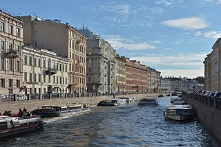
Русский: Мойка (река) Санкт-Петербурге
Italiano: Veduta verso sud del fiume Moyka dal ponte Pevchesky a San Pietroburgo. |
||||||
| Date | |||||||
| Source | Own work | ||||||
| Author |
|
||||||
| Permission (Reusing this file) |
Own work, attribution required (Multi-license with GFDL and Creative Commons CC-BY 2.5). Suggested capture: Photo by Wolfgang Moroder | ||||||
| Other versions |
 |

| Object location | | View this and other nearby images on: OpenStreetMap |
|---|
Licensing[edit]
I, the copyright holder of this work, hereby publish it under the following licenses:

|
Permission is granted to copy, distribute and/or modify this document under the terms of the GNU Free Documentation License, Version 1.2 or any later version published by the Free Software Foundation; with no Invariant Sections, no Front-Cover Texts, and no Back-Cover Texts. A copy of the license is included in the section entitled GNU Free Documentation License. |
This file is licensed under the Creative Commons Attribution-Share Alike 3.0 Unported, 2.5 Generic, 2.0 Generic and 1.0 Generic license.
- You are free:
- to share – to copy, distribute and transmit the work
- to remix – to adapt the work
- Under the following conditions:
- attribution – You must give appropriate credit, provide a link to the license, and indicate if changes were made. You may do so in any reasonable manner, but not in any way that suggests the licensor endorses you or your use.
- share alike – If you remix, transform, or build upon the material, you must distribute your contributions under the same or compatible license as the original.
You may select the license of your choice.
This image has been assessed using the Quality image guidelines and is considered a Quality image.
|

|
This image has been assessed under the valued image criteria and is considered the most valued image on Commons within the scope: View south of Moyka river from Pevchesky Bridge. You can see its nomination here. |
| Annotations | This image is annotated: View the annotations at Commons |

File history
Click on a date/time to view the file as it appeared at that time.
| Date/Time | Thumbnail | Dimensions | User | Comment | |
|---|---|---|---|---|---|
| current | 09:43, 17 October 2015 | | 7,360 × 4,912 (16.93 MB) | Moroder (talk | contribs) | {{int:filedesc}} == {{Information |Description= {{en|1=View South from the Pevchesky bridge of the Moyka River in Saint Petersburg.}} {{ru|1=Певческий мост Санкт-... |
You cannot overwrite this file.
File usage on Commons
The following 7 pages use this file:
- User talk:Moroder/Archives 2015-4
- Commons:Quality images/Subject/Architecture/Cityscapes/Archive 2015
- Commons:Quality images candidates/Archives October 20 2015
- Commons:Valued image candidates/Moyka river in Saint Petersburg view south from Pevchesky bridge.jpg
- File:Moika Embankment 28 Saint Petersburg.jpg
- File:Moyka river in Saint Petersburg view NE .jpg
- File:Moyka river in Saint Petersburg view south from Pevchesky bridge.jpg
File usage on other wikis
The following other wikis use this file:
- Usage on bg.wikipedia.org
- Usage on en.wikivoyage.org
- Usage on pih.wikipedia.org
- Usage on pl.wikivoyage.org
- Usage on xmf.wikipedia.org
- Usage on zh.wikivoyage.org