File:Moyeni tracksite features.png
Jump to navigation
Jump to search
Size of this preview: 302 × 599 pixels. Other resolutions: 121 × 240 pixels | 242 × 480 pixels | 387 × 768 pixels | 516 × 1,024 pixels | 1,938 × 3,845 pixels.
Original file (1,938 × 3,845 pixels, file size: 1.44 MB, MIME type: image/png)
Captions
Captions
Add a one-line explanation of what this file represents
Summary[edit]
| Description |
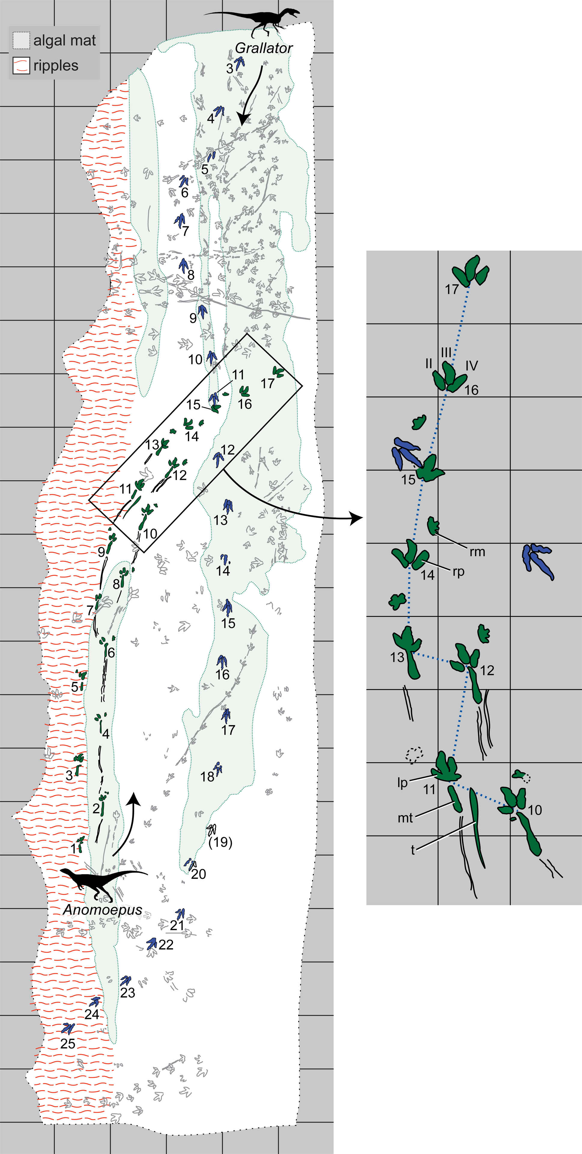
English: Map of major geological features and tracks at the Moyeni tracksite.
Trackways of Anomoepus and Grallator are in solid green and blue, respectively; all other trackways are in 50% grey. Trackway numbering (Arabic numerals) begins with the first recognized step of each trackmaker. Grallator tracks 1 and 2 are not shown because they are now underneath a retaining wall. Red wavy lines indicate ripple marks; solid light grey fields indicate algal-matted surface. The inset highlights postural and gait changes in the Anomoepus trackway, which was made by a basal ornithischian. A shift from wide-gauge to narrow-gauge posture (between tracks 13 and 14) is marked by shift in pace angulation (blue dotted line) and was accompanied by a brief pause, during which the tail registered on the substrate when tracks 12 and 13 were impressed. The shift from a quadrupedal to a bipedal gait (between tracks 15 and 16) occurs atop the algal matted surface. Note that Grallator track 11 (blue) overprints Anomoepus track 15, indicating it was made later. Grid pattern forms 1 meter squares for both maps. Abbreviations: lm, left manus; lp, left pes; mt, metatarsus; rm, right manus; rp, right pes; t, tail; Roman numerals indicate pedal digits. |
| Date | |
| Source | Wilson J.; Marsicano, C; Smith, R. (2009). "Dynamic Locomotor Capabilities Revealed by Early Dinosaur Trackmakers from Southern Africa Trackmakers". PLoS ONE 4 (10). DOI:10.1371/journal.pone.0007331. |
| Author | Wilson J.; Marsicano, C; Smith, R. |
Licensing[edit]
|
This file is licensed under the Creative Commons Attribution 2.5 Generic license.
|
This file was published in a Public Library of Science journal. Their website states that the content of all PLOS journals is published under the Creative Commons Attribution 4.0 license (or its previous version depending on the publication date), unless indicated otherwise.
|
This file, which was originally posted to
journals.plos.org, was reviewed on 18 December 2017 by reviewer Taivo, who confirmed that it was available there under the stated license on that date.
|
File history
Click on a date/time to view the file as it appeared at that time.
| Date/Time | Thumbnail | Dimensions | User | Comment | |
|---|---|---|---|---|---|
| current | 23:16, 20 March 2012 | | 1,938 × 3,845 (1.44 MB) | Ras67 (talk | contribs) | cropped, background removed |
| 01:22, 18 January 2010 |  | 1,993 × 3,904 (1.38 MB) | Spotty11222 (talk | contribs) | {{Information |Description={{en|1='''Map of major geological features and tracks at the Moyeni tracksite.''' Trackways of ''Anomoepus'' and ''Grallator'' are in solid green and blue, respectively; all other trackways are in 50% grey. |
You cannot overwrite this file.
File usage on Commons
There are no pages that use this file.
File usage on other wikis
The following other wikis use this file:
- Usage on en.wikipedia.org
- Usage on fr.wikipedia.org
- Usage on la.wikipedia.org
- Usage on or.wikipedia.org