File:Moyen Orient 3mil aC.svg
Jump to navigation
Jump to search

Size of this PNG preview of this SVG file: 800 × 450 pixels. Other resolutions: 320 × 180 pixels | 640 × 360 pixels | 1,024 × 575 pixels | 1,280 × 719 pixels | 2,560 × 1,439 pixels | 2,285 × 1,284 pixels.
Original file (SVG file, nominally 2,285 × 1,284 pixels, file size: 4.13 MB)
Captions
Captions
Add a one-line explanation of what this file represents
Summary[edit]

|
This SVG file contains embedded text that can be translated into your language, using any capable SVG editor, text editor or the SVG Translate tool. For more information see: About translating SVG files. |
This W3C-unspecified vector image was created with Inkscape .
| Description |
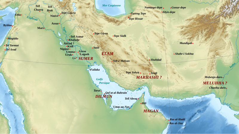
English: Middle East during the second half of the 3rd millennium BC (ED III, Akkad and Ur III periods). Français : Le Moyen-Orient dans la seconde moitié du IIIe millénaire av. J.-C. (périodes DA III, Akkad et Ur III). |
| Date | (UTC) |
| Source | |
| Author |
|
| Other versions |
|

| This is a retouched picture, which means that it has been digitally altered from its original version. Modifications: Ajout des sites et régions. The original can be viewed here: Middle East topographic map-blank.svg:
|
Licensing[edit]
I, the copyright holder of this work, hereby publish it under the following licenses:
This file is licensed under the Creative Commons Attribution-Share Alike 3.0 Unported, 2.5 Generic, 2.0 Generic and 1.0 Generic license.
- You are free:
- to share – to copy, distribute and transmit the work
- to remix – to adapt the work
- Under the following conditions:
- attribution – You must give appropriate credit, provide a link to the license, and indicate if changes were made. You may do so in any reasonable manner, but not in any way that suggests the licensor endorses you or your use.
- share alike – If you remix, transform, or build upon the material, you must distribute your contributions under the same or compatible license as the original.

|
Permission is granted to copy, distribute and/or modify this document under the terms of the GNU Free Documentation License, Version 1.2 or any later version published by the Free Software Foundation; with no Invariant Sections, no Front-Cover Texts, and no Back-Cover Texts. A copy of the license is included in the section entitled GNU Free Documentation License. |
You may select the license of your choice.
Original upload log[edit]
This image is a derivative work of the following images:
- File:Middle_East_topographic_map-blank.svg licensed with Cc-by-sa-3.0,2.5,2.0,1.0, GFDL
- 2010-11-03T17:52:56Z Sémhur 3097x1938 (10510751 Bytes) == {{int:filedesc}} == {{Information |Description={{Multilingual description |en= Blank physical map of the [[:en:Middle East|Middle East]] |fr= Carte physique vierge du [[:fr:Moyen-Orient|Moyen-Orient]]. }} |Source={{own}}.
Uploaded with derivativeFX
File history
Click on a date/time to view the file as it appeared at that time.
| Date/Time | Thumbnail | Dimensions | User | Comment | |
|---|---|---|---|---|---|
| current | 19:52, 4 March 2024 | | 2,285 × 1,284 (4.13 MB) | Josef K.3737 (talk | contribs) | File uploaded using svgtranslate tool (https://svgtranslate.toolforge.org/). Added translation for en. |
| 11:16, 13 November 2011 |  | 2,285 × 1,284 (4.12 MB) | Zunkir (talk | contribs) | == {{int:filedesc}} == {{translation possible}} {{Inkscape}} {{Information |Description={{Multilingual description |fr= Le Moyen-Orient dans la seconde moitié du IIIe millénaire av. J.-C. (périodes DA III, Akkad et Ur III). |en= Middle East during the |
You cannot overwrite this file.
File usage on Commons
The following 3 pages use this file:
File usage on other wikis
The following other wikis use this file:
- Usage on af.wikipedia.org
- Usage on arz.wikipedia.org
- Usage on ca.wikipedia.org
- Usage on cs.wikipedia.org
- Usage on de.wikipedia.org
- Usage on en.wikipedia.org
- Usage on eo.wikipedia.org
- Usage on eu.wikipedia.org
- Usage on fa.wikipedia.org
- Usage on fa.wikibooks.org
- Usage on fr.wikipedia.org
- Civilisation de la vallée de l'Indus
- Histoire de l'Irak
- Suse (Iran)
- Période des dynasties archaïques
- Gudea
- Lagash
- Dilmun
- Troisième dynastie d'Ur
- Civilisation proto-élamite
- Arabes
- Proche-Orient ancien
- Magan
- Meluhha
- Sumer
- Utilisateur:Zunkir/POA autres
- Portail:Proche-Orient ancien/Carte
- Portail:Proche-Orient ancien/Carte/1
- Littérature irakienne
- Usage on hi.wikipedia.org
- Usage on hu.wikipedia.org
- Usage on it.wikipedia.org
- Usage on ja.wikipedia.org
- Usage on ko.wikipedia.org
- Usage on lt.wikipedia.org
View more global usage of this file.