File:Mountain-systems over 2500 m-Worldmap.png
Jump to navigation
Jump to search

Size of this preview: 800 × 448 pixels. Other resolutions: 320 × 179 pixels | 640 × 359 pixels | 1,024 × 574 pixels | 1,280 × 717 pixels | 2,560 × 1,434 pixels | 4,127 × 2,312 pixels.
Original file (4,127 × 2,312 pixels, file size: 4.53 MB, MIME type: image/png)
Captions
Captions
Add a one-line explanation of what this file represents
Summary[edit]
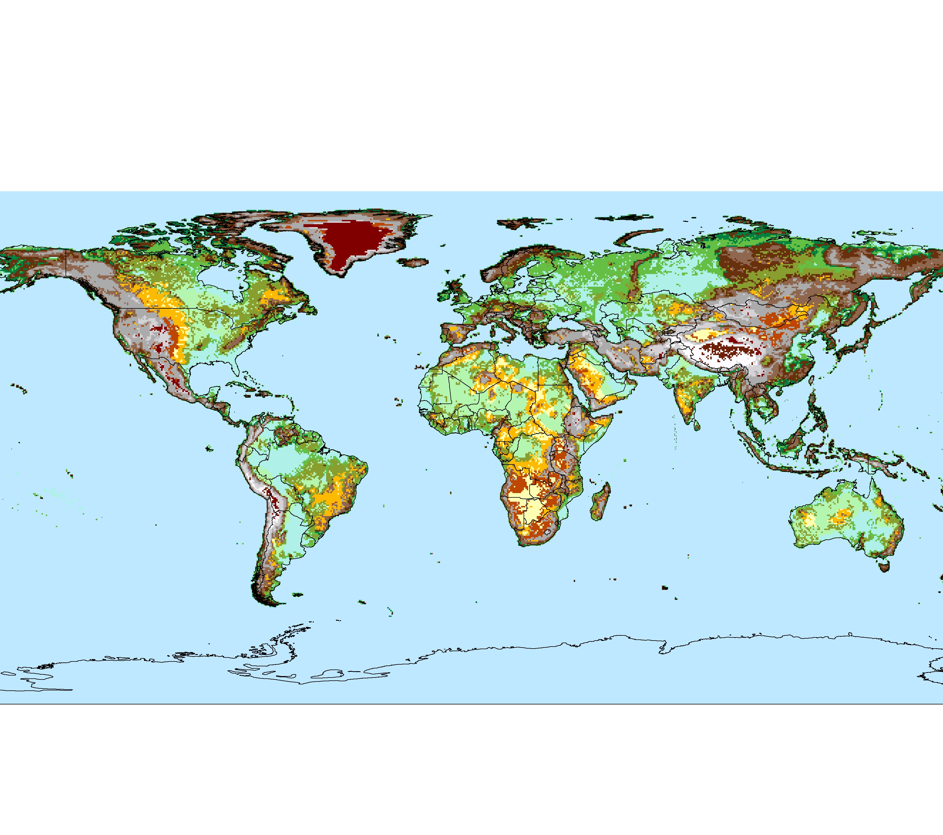
| Description |
Deutsch: Alle über 2500 m hohen Gebirge der Erde (26 gelistete über 5.000 km² |
| Date | |
| Source | Own work, abgeleitet von File:Landforms-Worldmap.png |
| Author | Fährtenleser |
Vorgaben[edit]
- Anzahl der Vier-, Fünf-, Sechs-, Sieben- und Achttausender (Hauptgipfel) einer Gebirgsgruppe[1]
- Durchschnittliche Höhe der „Top Ten“ der Gruppe
- Größe der umgebenden – weitestgehend zusammenhängenden – Hochgebirge|Hochgebirgsfläche,
Quellen[edit]
Grundkarte[edit]
- Kartendaten: © OpenStreetMap, Mitwirkende: SRTM | Kartendarstellung: © OpenTopoMap (CC-BY-SA)
Landformen[edit]
Hoch- und Mittelgebirge[edit]
- Deniz Karagülle, Charlie Frye, Roger Sayre, Sean Breyer, Peter Aniello, Randy Vaughan und Dawn Wright: Modeling global Hammond landform regions from 250-m elevation data., Transactions in GIS, [DOI: 10.1111/tgis.12265], 2017 – übertragen in Global Montain Explorer, Erfassung der Gebirge der Erde auf zoombaren Karten. Ein Gemeinschaftsprojekt von Mountain Research Initiative (MRI), Center for Development and the Environment (CDE) sowie United States Geological Survey und Environmental Systems Research Institute (ESRI) im Rahmen der Initiative Global Earth Observations - Global Network for Observation and Information in Mountain Environments (GEO-GNOME)
- geringfügig vereinfacht nach opentopomap.org (siehe Kartographie) sowie nach Hans Braxmeier: Relief Map
andere Landformen[edit]
- Michel Meybeck, Pamela Green, Charles Vörösmarty: A New Typology for Mountains and Other Relief Classes, in Mountain Research and Development, Vol. 1, Nr. 1, 1. Februar 2001, S. 34–45, DOI:10.1659/0276-4741(2001)021[0034:ANTFMA]2.0.CO;2, Karte auf esdac.jrc.ec.europa.eu, abgerufen am 14. Februar 2021
- Grenzen zwischen Tiefebenen und Tafelländern in höherer Auflösung nach: FloodMap.net, Stand 6. Dezember 2020
Licensing[edit]
I, the copyright holder of this work, hereby publish it under the following license:
This file is licensed under the Creative Commons Attribution-Share Alike 4.0 International license.
- You are free:
- to share – to copy, distribute and transmit the work
- to remix – to adapt the work
- Under the following conditions:
- attribution – You must give appropriate credit, provide a link to the license, and indicate if changes were made. You may do so in any reasonable manner, but not in any way that suggests the licensor endorses you or your use.
- share alike – If you remix, transform, or build upon the material, you must distribute your contributions under the same or compatible license as the original.
- ↑ Vorzugsweise ermittelt über die jeweiligen Einträge „Ten Highest Peaks“ im Peakbagger.com Mountain Range Classification Systems auf peakbagger.com, abgerufen im Dezember 2020.
- ↑ Außer für Antarktika nach Valerie Kapos, Jonathan Rhind, Mary Edwards, Martin F. Price und Corinna Ravilious: Developing a map of the world’s mountain forests, in: M. Price und N. Butt (Hrsg.): Forests in Sustainable Mountain Development: A State of Knowledge Report for 2000. IUFRO, Research Series 5, CAB International Publishing, New York 2000, DOI: 10.1007/1-4020-3508-X_52, S. 4–9. Visualisiert in der zoombaren Karte K1 des Global Mountain Explorer, ein Gemeinschaftsprojekt von Mountain Research Initiative (MRI), Center for Development and the Environment (CDE) sowie United States Geological Survey und Environmental Systems Research Institute (ESRI) im Rahmen der Initiative Global Earth Observations - Global Network for Observation and Information in Mountain Environments (GEO-GNOME), abgerufen am 24. Dezember 2020.
- ↑ Deniz Karagülle, Charlie Frye, Roger Sayre, Sean Breyer, Peter Aniello, Randy Vaughan und Dawn Wright: Modeling global Hammond landform regions from 250-m elevation data. Transactions in GIS 21(5):1040–1060, 2017, https://dx.doi.org/10.1111/tgis.12265. Visualisiert in der zoombaren Karte K3 des Global Mountain Explorer, ein Gemeinschaftsprojekt von Mountain Research Initiative (MRI), Center for Development and the Environment (CDE) sowie United States Geological Survey und Environmental Systems Research Institute (ESRI) im Rahmen der Initiative Global Earth Observations - Global Network for Observation and Information in Mountain Environments (GEO-GNOME), abgerufen am 24. Dezember 2020.
File history
Click on a date/time to view the file as it appeared at that time.
| Date/Time | Thumbnail | Dimensions | User | Comment | |
|---|---|---|---|---|---|
| current | 09:00, 16 September 2021 | | 4,127 × 2,312 (4.53 MB) | Fährtenleser (talk | contribs) | Fehler in der Legende behoben |
| 07:25, 20 June 2021 |  | 4,127 × 2,312 (1.36 MB) | Fährtenleser (talk | contribs) | == {{int:filedesc}} == {{Information |description={{de|1=26 über 2500 m hohe Gebirgsmassive der Erde}} |date=2021-06-20 |source={{own}}, abgeleitet von File:Landforms-Worldmap.png |author=Fährtenleser |permission= |other_versions= |other_fields= }} == Vorgaben == * Anzahl der Vier-, Fünf-, Sechs-, Sieben- und Achttausender (Hauptgipfel) einer Gebirgsgruppe<ref>Vorzugsweise ermittelt über die jeweiligen Einträge „Ten Highest Peaks“ im ''[https://peakbagger.com/RangI... |
You cannot overwrite this file.
File usage on Commons
There are no pages that use this file.
File usage on other wikis
The following other wikis use this file:
- Usage on de.wikipedia.org