File:MountSeirOSM.png
Jump to navigation
Jump to search

Size of this preview: 568 × 599 pixels. Other resolutions: 227 × 240 pixels | 455 × 480 pixels | 673 × 710 pixels.
Original file (673 × 710 pixels, file size: 500 KB, MIME type: image/png)
Captions
Captions
Add a one-line explanation of what this file represents
Summary
[edit]
| Description |
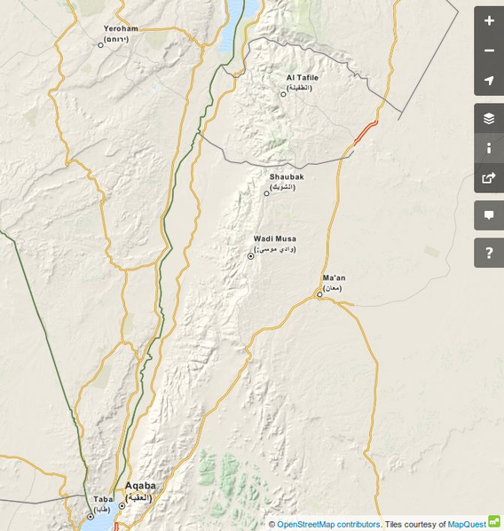
עברית: מפה שבה אפשר לראות בבירור את רכס הרי שעיר הבולט מעל סביבתו. זהו הפס הלבן המשתרע בדרום-מזרח ממלכת ירדן, מדרום ים המלח ועד מפרץ אילת. הגבולות של הר שעיר הם העמקים שמסביבו. אלה מקומות שנוח לבנות בהם כבישים, ולכן אפשר לראות בבירור את גבולות הר שעיר בקוים הכתומים המקיפים אותו, המציינים כבישים: כביש הבקעה הירדני (בין ים המלח לעקבה) ממערבו וכביש עקבה-מען ממזרחו. הגבול הצפוני של הר שעיר הוא נחל זרד - הקו השחור העובר מצפון לאל-תפילה.
English: A map showing Mount Seir, strething from the south of the Dead Sea down to Eilat. |
| Date | |
| Source | Open Street Map https://www.openstreetmap.org/#map=9/30.4487/35.3169&layers=Q |
| Author | OpenStreetMap contributors |
Licensing
[edit]
This file is licensed under the Creative Commons Attribution-Share Alike 2.5 Generic license.
- You are free:
- to share – to copy, distribute and transmit the work
- to remix – to adapt the work
- Under the following conditions:
- attribution – You must give appropriate credit, provide a link to the license, and indicate if changes were made. You may do so in any reasonable manner, but not in any way that suggests the licensor endorses you or your use.
- share alike – If you remix, transform, or build upon the material, you must distribute your contributions under the same or compatible license as the original.
File history
Click on a date/time to view the file as it appeared at that time.
| Date/Time | Thumbnail | Dimensions | User | Comment | |
|---|---|---|---|---|---|
| current | 13:50, 23 April 2015 | | 673 × 710 (500 KB) | Erel Segal (talk | contribs) | User created page with UploadWizard |
You cannot overwrite this file.
File usage on Commons
There are no pages that use this file.
File usage on other wikis
The following other wikis use this file:
- Usage on ar.wikipedia.org
- Usage on he.wikipedia.org
- Usage on it.wikipedia.org
- Usage on nl.wikipedia.org