File:Moscow trolleybus map 2016-11-24 Openstreetmap.png
Jump to navigation
Jump to search

Size of this preview: 471 × 599 pixels. Other resolutions: 189 × 240 pixels | 377 × 480 pixels | 604 × 768 pixels | 805 × 1,024 pixels | 1,610 × 2,048 pixels | 3,500 × 4,452 pixels.
Original file (3,500 × 4,452 pixels, file size: 1.75 MB, MIME type: image/png)
Captions
Captions
Add a one-line explanation of what this file represents
Summary[edit]
| Description |
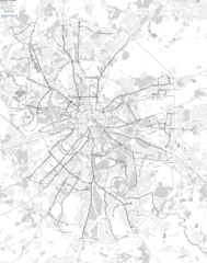
Русский: Карта троллейбусных маршрутов Москвы. Сгенерировано по данным OpenStreetMap. Обработка в osm-mostrans, рендеринг: nextgis.com
Информация о генераторе и новые версии карт: https://trolleway.github.io/osm-mostrans/ |
| PNG development | |
| Date | |
| Source | http://www.openstreetmap.org |
| Creator |
OpenStreetMap contributors / User:Svetlov_Artem |
| Georeferencing | If inappropriate please set warp_status = skip to hide. |
Licensing[edit]
This file is licensed under the Creative Commons Attribution-Share Alike 4.0 International license.
- You are free:
- to share – to copy, distribute and transmit the work
- to remix – to adapt the work
- Under the following conditions:
- attribution – You must give appropriate credit, provide a link to the license, and indicate if changes were made. You may do so in any reasonable manner, but not in any way that suggests the licensor endorses you or your use.
- share alike – If you remix, transform, or build upon the material, you must distribute your contributions under the same or compatible license as the original.
File history
Click on a date/time to view the file as it appeared at that time.
| Date/Time | Thumbnail | Dimensions | User | Comment | |
|---|---|---|---|---|---|
| current | 20:11, 24 November 2016 | | 3,500 × 4,452 (1.75 MB) | Svetlov Artem (talk | contribs) | == {{int:filedesc}} == {{Information | Description = {{ ru|Карта троллейбусных маршрутов Москвы. Сгенерировано по данным OpenStreetMap. Обработка в osm-mostrans, рендеринг: nextgi... |
You cannot overwrite this file.
File usage on Commons
The following 5 pages use this file:
- User:Chumwa/OgreBot/Potential transport maps/2016 November 21-30
- User:Chumwa/OgreBot/Public transport information/2016 November 21-30
- User:Chumwa/OgreBot/Transport Maps/2016 November 21-30
- User:Chumwa/OgreBot/Travel and communication maps/2016 November 21-30
- User:Stolbovsky/Recent uploads/Moscow/2016 November 21-30