File:Moon crustal thickness map NASA-JPL.jpg
Jump to navigation
Jump to search

Size of this preview: 800 × 515 pixels. Other resolutions: 320 × 206 pixels | 640 × 412 pixels | 1,024 × 659 pixels | 1,280 × 824 pixels | 2,120 × 1,364 pixels.
Original file (2,120 × 1,364 pixels, file size: 1.79 MB, MIME type: image/jpeg)
Captions
Captions
Add a one-line explanation of what this file represents
Summary[edit]
| Description |
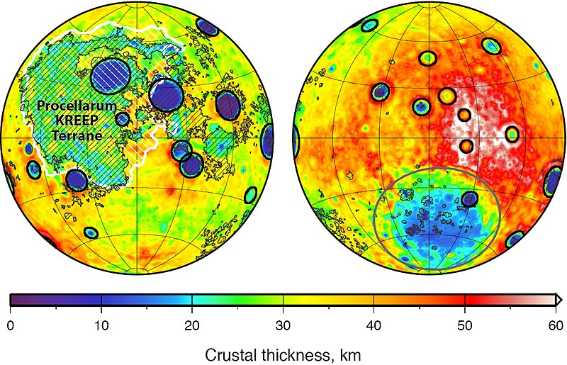
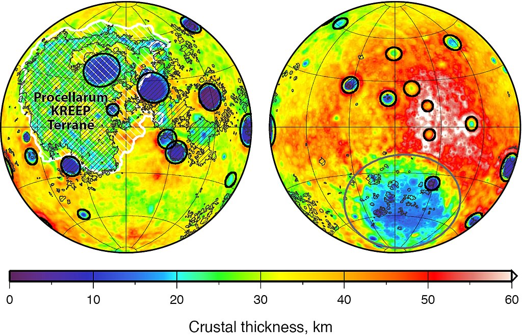
English: Global map of crustal thickness of the moon derived from gravity data obtained by NASA’s GRAIL spacecraft. The lunar near side is represented on the left hemisphere. The far side is represented in the right hemisphere.
In the left hemisphere, outlined in white, is the Procellarum KREEP Terrane, a large province on the near side of the moon which contains high abundances of potassium, rare earth elements and phosphorus [as well as Uranium and Thorium]. Excluding the Aitken basin at the south pole (the gray circle on the lower half of the far side hemisphere), there are 12 impact basins with crustal thinning that have diameters greater than 124 miles (200 kilometers) on each hemisphere. Those are marked with black circles. The image is presented in two hemispherical Lambert azimuthal equal-area projections centered over the near side (left), and far side (right) hemispheres. Deutsch: Karte der Krustendicke des Mondes, basierend auf Daten der GRAIL-Sonde der NASA. Die erdzugewandte Seite des Mondes ist links abgebildet, die erdabgewandte Seite ist rechts abgebildet. In der linken Teilabbildung weiß umrandet und schraffiert ist das Procellarum-KREEP-Terran, ein großer Bereich auf der erdzugewandten Seite des Mondes, der durch eine erhöhte Häufigkeit von Kalium, Seltenerdmemetallen und Phosphor [sowie Uran und Thorium] gekennzeichnet ist. Abgesehen vom Aitken-Becken in der Südpolarregion (markiert durch den grauen Kreis in der rechten Teilabbildung) gibt es in jeder der beiden Hemisphären 12 Einschlagsbecken mit ausgedünnter Kruste, die einen Durchmesser von mehr als 200 Kilometern (124 Meilen) aufweisen. Diese sind durch schwarze Kreise gekennzeichnet. Die Karte ist erstellt in hemisphärischer flächentreuer Lambert’scher Azimutalprojektion, zentriert auf die erdzugewandte (links) und erdabgewandte (rechts) Hemisphäre. |
| Date | (released) |
| Source |
|
| Author | NASA/JPL-Caltech/S. Miljkovic |
This image or video was catalogued by Jet Propulsion Laboratory of the United States National Aeronautics and Space Administration (NASA) under Photo ID: PIA17674. This tag does not indicate the copyright status of the attached work. A normal copyright tag is still required. See Commons:Licensing. Other languages:
|
Licensing[edit]
| This file is in the public domain in the United States because it was solely created by NASA. NASA copyright policy states that "NASA material is not protected by copyright unless noted". (See Template:PD-USGov, NASA copyright policy page or JPL Image Use Policy.) | ||
 |
Warnings:
|
File history
Click on a date/time to view the file as it appeared at that time.
| Date/Time | Thumbnail | Dimensions | User | Comment | |
|---|---|---|---|---|---|
| current | 14:52, 7 January 2019 | | 2,120 × 1,364 (1.79 MB) | Gretarsson (talk | contribs) | {{Information |description ={{en|1=Global map of crustal thickness of the moon derived from gravity data obtained by NASA’s GRAIL spacecraft. The lunar near side is represented on the left hemisphere. The far side is represented in the right hemisphere.<br/> In the left hemisphere, outlined in white, is the Procellarum KREEP Terrane, a large province on the near side of the moon which contains high abundances of potassium, rare earth elements and phosphorus. Excluding the Aitk... |
You cannot overwrite this file.
File usage on Commons
The following 2 pages use this file:
File usage on other wikis
The following other wikis use this file:
- Usage on de.wikipedia.org
- Usage on en.wikipedia.org
- Usage on fr.wikibooks.org