File:Montegiardino map.svg
Jump to navigation
Jump to search

Size of this PNG preview of this SVG file: 623 × 599 pixels. Other resolutions: 249 × 240 pixels | 499 × 480 pixels | 798 × 768 pixels | 1,064 × 1,024 pixels | 2,129 × 2,048 pixels | 1,000 × 962 pixels.
Original file (SVG file, nominally 1,000 × 962 pixels, file size: 6 KB)
Captions
Captions
Add a one-line explanation of what this file represents
| Description |
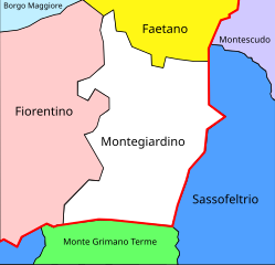
Deutsch: Lage des „Castello“ Montegiardino an der Grenze (rot) von San Marino zu Italien.
Esperanto: Situo de la „kastelo“ (komunumo) Montegiardino ĉe la limo (ruĝa) de San-Marino al Italio.
Italiano: Situazione del castello di Montegiardino alla frontiera (in rosso) di San Marino con l'Italia. |
|||
| Date | ||||
| Source | Own work, File:Montegiardino map.gif | |||
| Author | Renardo la vulpo, Andre86 | |||
| Permission (Reusing this file) |
I, the copyright holder of this work, hereby publish it under the following license:
|
This file was derived from: Montegiardino map.gif
File history
Click on a date/time to view the file as it appeared at that time.
| Date/Time | Thumbnail | Dimensions | User | Comment | |
|---|---|---|---|---|---|
| current | 15:52, 25 July 2016 | | 1,000 × 962 (6 KB) | Renardo la vulpo (talk | contribs) | {{Information |Description={{de|1=Lage des „Castello“ Montegiardino an der Grenze (rot) von San Marino zu Italien.}} {{eo|1=Situo de la „kastelo“ (komunumo) Montegiardino ĉe la limo (ruĝa) de San-Marino al Italio.}}... |
You cannot overwrite this file.
File usage on Commons
The following page uses this file:
File usage on other wikis
The following other wikis use this file:
- Usage on it.wikipedia.org
- Usage on rn.wikipedia.org