File:Molana Priory Ground Plan.svg

Original file (SVG file, nominally 600 × 600 pixels, file size: 10 KB)
Captions
Captions
Summary[edit]
This is a ground plan of Molana Priory, County Waterford, Ireland, which was created by Andreas F. Borchert.
Literature and sources[edit]
This plan is based upon:
- Patrick Power: Ancient Ruined Churches of Co. Waterford. Out of Journal of the Waterford and South-East of Ireland Archaeological Society, 4/1898, pp. 83-95 and 195-219. The section about Molana Priory is to be found on the pages 209–212.
- Patrick Power: The Abbey of Molana, Co. Waterford. Out of The Journal of the Royal Society of Antiquaries of Ireland, 62/1932, pp. 142–152.
- My visit of Molana Priory on August 7th, 2007. A collection of the pictures taken during this visit can be found in this category.
This plan has been created from scratch, i.e. it is not copied from either of the two papers of Patrick Power nor has it a similar design. Patrick Power has however published quite a number of measures which allowed to redraw a plan. This opportunity has been also used to fix some minor errors in Power's plan. Still, this plan is just a sketch which relies on the (incomplete) set of measures by P. Power and my personal inspection. I haven't measured anything myself.
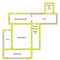
General layout[edit]
This version of the plan does not provide any captions to allow an easy adaption to various language-specific versions. The rooms in the diagram from top to bottom, from left to right:
- On the upper right is the Prior's Lodge to be found which was a two storey structure.
- Below are the nave and the choir.
- In the center is the cloister garth.
- The west wing (left side) was used for the kitchen. Please note that there is a well (not drawn) at the outside corner at the north door of the kitchen.
- The east wing (right side) with two storeys gave room to the sacristy, the chapter room, the parlour, and, on the upper floor, to the dormitory. The stairs were apparently at the southern gable.
- The south wing (bottom of this plan) was used for the refectory.
Walls that are still standing (at least in parts) have been painted yellow; former walls, i.e. ruined parts of the structure, have a grey color.
Measures taken by Patrick Power[edit]
Following measures were published by Patrick Power and used for this plan. Please note that all measures were taken inside the rooms. Power gave all measures in feet and inches. This has been converted into the metric system.
- The thickness of the walls is 0.81 m.
- Nave and choir: Overall length 37.03 m, width = 7.47 m.
- Length of the old nave: 17.07 m.
- Length of the choir: 19.05 m.
- Choir windows: height = 4.57 m, width outside = 0,56 m, width inside = 2.08 m.
- Ruined east window of the choir. Estimations by P. Power: width inside = 2.08 m, height = 6.10 m.
- Prior's lodge measures 7.32 m x 5.59 m.
- Cloister garth: 19.74 m x 14.86 m.
- Sacristy measures 5.66 m x 3.12 m.
- Chapter room measures 5.94 m x 5.66 m. Windows: height = 1.68 m, width inside = 1.37 m. Door width = 1.45 m.
- Parlour: door width = 1.27 m.
- Staircase: door width = 1.45 m.
- Refectory measures 21.49 m x 6.17 m. Window: height = 3.66 m, width inside = 1.37 m.
- Kitchen was given by Power as 14.27 m x 3.05 m. This has been corrected to 14.27 m x 5.83 m. A correction was possible thanks to measures of the cloister garth and the refectory.
Alternative Variants[edit]
Following variants provide captions in different languages:
-
 German
 -
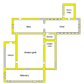 English


Acknowledgements[edit]
AnyFile helped to get this SVG in conformance to the SVG specification.
Disclaimer[edit]
This plan is just a sketch. Many details are just estimated. For example, the exact location of the prior's lodge relative to the choir is not known to me. Nearly all windows and doors have likewise been placed and dimensioned on base of rough estimates. The windows and earlier inner walls of the two storey east wing and the prior's lodge have not been included in the diagram. There are some additional structures outside which have not been included in this plan: One is attached to the north side of the wall and one is connected with the south gable of the east wing. They are not mentioned in Power's paper nor included in one of his plans. In addition, there is a detached two storeyed house on the island which is also not mentioned by Power.
Some of the details in this plan are due to the work in the beginning of the 19th century by the Smyth family who integrated the ruines of this monastery in their park. The north door of the nave is such a late addition. A door which allowed to enter the nave from the cloister garth had been blocked up. There is yet (to my knowledge) no detailed analysis available about the extent of the work done by the Smyth family which would allow to learn more about the previous state of the ruins.
In summary: This plan is intended to provide a basic orientation. No research or further work should be based on it.
Licensing[edit]

|
Permission is granted to copy, distribute and/or modify this document under the terms of the GNU Free Documentation License, Version 1.2 or any later version published by the Free Software Foundation; with no Invariant Sections, no Front-Cover Texts, and no Back-Cover Texts. A copy of the license is included in the section entitled GNU Free Documentation License. |
- You are free:
- to share – to copy, distribute and transmit the work
- to remix – to adapt the work
- Under the following conditions:
- attribution – You must give appropriate credit, provide a link to the license, and indicate if changes were made. You may do so in any reasonable manner, but not in any way that suggests the licensor endorses you or your use.
- share alike – If you remix, transform, or build upon the material, you must distribute your contributions under the same or compatible license as the original.
File history
Click on a date/time to view the file as it appeared at that time.
| Date/Time | Thumbnail | Dimensions | User | Comment | |
|---|---|---|---|---|---|
| current | 19:06, 30 September 2007 | | 600 × 600 (10 KB) | AnyFile (talk | contribs) | Another test to try to have the image displayed when converted to png (I explicited inserted in path element commands L after M) |
| 18:49, 30 September 2007 |  | 600 × 600 (10 KB) | AnyFile (talk | contribs) | unused definition removed, redefined the prototype of the svg image to a more standard one and declare width and height (both to 600px) (this change was made to try to overcame problem in png rendering signalled by the original author [http://commons.wiki | |
| 16:03, 30 September 2007 |  | 512 × 511 (16 KB) | AFBorchert (talk | contribs) | This is a ground plan of Molana Priory, County Waterford, Ireland, which was created by Andreas F. Borchert. == Literature and sources == This plan is based upon * Patrick Power: ''Ancient Ruined Churches of Co. Waterford''. Out of ' |
You cannot overwrite this file.
File usage on Commons
The following 2 pages use this file: