File:MoabiterWerder1.png
Jump to navigation
Jump to search

Size of this preview: 800 × 533 pixels. Other resolutions: 320 × 213 pixels | 640 × 426 pixels | 1,151 × 767 pixels.
Original file (1,151 × 767 pixels, file size: 215 KB, MIME type: image/png)
Captions
Captions
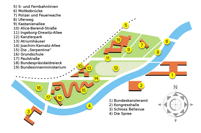
Berlin, Moabiter Werder. Plan of situation
| Description |
Berlin, Moabiter Werder. Plan of situation. |
|||||||||
| Date | ||||||||||
| Source | own graphic | |||||||||
| Creator |
Manfred Brueckels |
|||||||||
| Permission (Reusing this file) |
PD-user Eisenacher | |||||||||
| Geotemporal data | ||||||||||
| Bounding box |
|
|||||||||
| Georeferencing | ||||||||||
| Other versions |
|
|||||||||

| This work has been released into the public domain by its author, Eisenacher at German Wikipedia. This applies worldwide. In some countries this may not be legally possible; if so: Eisenacher grants anyone the right to use this work for any purpose, without any conditions, unless such conditions are required by law. |
File history
Click on a date/time to view the file as it appeared at that time.
| Date/Time | Thumbnail | Dimensions | User | Comment | |
|---|---|---|---|---|---|
| current | 13:17, 21 June 2019 | | 1,151 × 767 (215 KB) | 0000ff (talk | contribs) | corrected caption 14 acc. to talk page (checked) |
| 07:22, 25 October 2016 |  | 1,151 × 767 (220 KB) | 0000ff (talk | contribs) | corrected typo in caption | |
| 12:05, 10 February 2016 |  | 1,151 × 767 (172 KB) | 0000ff (talk | contribs) | added the Federal Ministry of the Interior (19) | |
| 22:58, 7 February 2016 |  | 1,151 × 767 (186 KB) | 0000ff (talk | contribs) | hot fix for label position for Alice-Berend-Straße (no 10); further update required: the new BMI building is missing (the sector to the left of no 9) | |
| 08:09, 30 August 2006 |  | 1,151 × 767 (173 KB) | Stephan Herz (talk | contribs) | {{Information| |Description=Berlin, Moabiter Werder. Plan of situation. |Source=own graphic |Date=2006 |Author=Manfred Brueckels |Permission=PD-user|Eisenacher |other_versions= - }} Category: Berlin Category: Buildings and structures |
You cannot overwrite this file.
File usage on Commons
The following 2 pages use this file:
File usage on other wikis
The following other wikis use this file:
- Usage on de.wikipedia.org
- Usage on no.wikipedia.org
- Usage on www.wikidata.org