File:Mississippi swampland ESA347251.jpg

Original file (1,920 × 2,035 pixels, file size: 5.37 MB, MIME type: image/jpeg)
Captions
Captions
Summary[edit]
| Description |
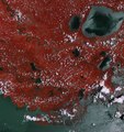
English: This Sentinel-2A ‘colour vision’ image captures part of the Mississippi swamps on the east and west banks of the Mississippi River, south of New Orleans and north of the Mississippi Delta.
From agricultural monitoring to charting changing lands, images from Europe’s Sentinel-2A ‘colour vision’ satellite can be used for many practical applications and to keep us, and our planet, safe. The red colour scattered throughout the image shows the enormous amount of vegetation in the area, while the grey represents the various bodies of water. Close to the heart of the snake-like Mississippi River, the image clearly shows the typical French-style fields, with rows of sugar cane, around the towns of Lucy, Edgard and Wallace. On the east bank of the Mississippi lie the towns of LaPlace, Reserve, Lions, Garyville and Mount Airy, each with industries along the river, including a chemical plant, sugar refinery, grain elevators and an oil refinery. Bayous are scattered all over the image. A bayou is a Franco-English term for an extremely slow-moving stream or river, marshy lake or wetland. They are commonly found in the Mississippi River Delta, famous within the states of Louisiana and Texas. Though fauna varies by region, many bayous are home to crawfish, certain species of shrimp, other shellfish, catfish, frogs, toads, American alligators and crocodiles, and the alligator snapping turtle. Towards the upper left part of the image, under the many clouds, lies Baton Rouge, the capital of Louisiana and its second-largest city. On the eastern bank of the Mississippi River, Baton Rouge is a major industrial, petrochemical, medical, research, motion picture and growing technology centre of the American south. The port of Baton Rouge is the ninth largest in the United States in terms of tonnage shipped. Sentinel-2A has been in orbit since 23 June, with its multispectral camera supplying optical images of Earth’s land and water bodies. It provides imagery of vegetation, soil and water cover, inland waterways and coastal areas. This image, captured on 15 July by Sentinel-2A, is featured on theEarth from Space video programme. |
| Date | |
| Source | http://www.esa.int/spaceinimages/Images/2015/09/Mississippi_swampland |
| Author | European Space Agency |
| Permission (Reusing this file) |
Copernicus Sentinel data (2015)/ESA,CC BY-SA 3.0 IGO |
| Other versions |
|
| Title | Mississippi swampland |
| Set | Earth observation image of the week |
| System | Copernicus |
| Mission | Sentinel-2 |
| Location | USA |
| Activity | Observing the Earth |
| Keywords | swamp; Satellite image; River; River delta |
Licensing[edit]
- You are free:
- to share – to copy, distribute and transmit the work
- to remix – to adapt the work
- Under the following conditions:
- attribution – You must give appropriate credit, provide a link to the license, and indicate if changes were made. You may do so in any reasonable manner, but not in any way that suggests the licensor endorses you or your use.
- share alike – If you remix, transform, or build upon the material, you must distribute your contributions under the same or compatible license as the original.

|
This image contains data from a satellite in the Copernicus Programme, such as Sentinel-1, Sentinel-2 or Sentinel-3. Attribution is required when using this image.
Attribution: Contains modified Copernicus Sentinel data {{{year}}}
The use of Copernicus Sentinel Data is regulated under EU law (Commission Delegated Regulation (EU) No 1159/2013 and Regulation (EU) No 377/2014). Relevant excerpts:
Free access shall be given to GMES dedicated data [...] made available through GMES dissemination platforms [...].
Access to GMES dedicated data [...] shall be given for the purpose of the following use in so far as it is lawful:
GMES dedicated data [...] may be used worldwide without limitations in time.
GMES dedicated data and GMES service information are provided to users without any express or implied warranty, including as regards quality and suitability for any purpose. |
File history
Click on a date/time to view the file as it appeared at that time.
| Date/Time | Thumbnail | Dimensions | User | Comment | |
|---|---|---|---|---|---|
| current | 00:51, 8 May 2017 | | 1,920 × 2,035 (5.37 MB) | Fæ (talk | contribs) | European Space Agency, Id 347251, http://www.esa.int/spaceinimages/Images/2015/09/Mississippi_swampland, User:Fæ/Project_list/ESA |
You cannot overwrite this file.
File usage on Commons
The following 2 pages use this file: