File:Midway Atoll map-zh.svg
Jump to navigation
Jump to search

Size of this PNG preview of this SVG file: 365 × 392 pixels. Other resolutions: 223 × 240 pixels | 447 × 480 pixels | 715 × 768 pixels | 953 × 1,024 pixels | 1,907 × 2,048 pixels.
Original file (SVG file, nominally 365 × 392 pixels, file size: 40 KB)
Captions
Captions
Add a one-line explanation of what this file represents
Summary[edit]
| Description |
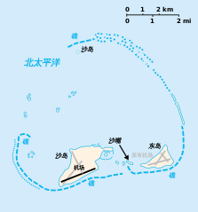
English: Midway Atoll with Sand Island, Spit Island and Eastern Island. Abandoned runways of Henderson Field in gray. |
| Date | (UTC) |
| Source |
This file was derived from: Midway Atoll map.svg:  |
| Author |
|
| This is a retouched picture, which means that it has been digitally altered from its original version. Modifications: Translated into Chinese. The original can be viewed here: Midway Atoll map.svg:
|
Licensing[edit]
I, the copyright holder of this work, hereby publish it under the following license:
This file is licensed under the Creative Commons Attribution-Share Alike 3.0 Unported license.
- You are free:
- to share – to copy, distribute and transmit the work
- to remix – to adapt the work
- Under the following conditions:
- attribution – You must give appropriate credit, provide a link to the license, and indicate if changes were made. You may do so in any reasonable manner, but not in any way that suggests the licensor endorses you or your use.
- share alike – If you remix, transform, or build upon the material, you must distribute your contributions under the same or compatible license as the original.
Original upload log[edit]
This image is a derivative work of the following images:
- File:Midway Atoll map.svg licensed with Cc-by-sa-3.0
- 2009-11-16T03:33:18Z Gooney birds 365x392 (37695 Bytes) {{Information |Description={{en|[[:en:Midway Atoll|Midway Atoll]] with Sand Island, Spit Island and Eastern Island. Abandoned runways of [[:en:Henderson Field (Midway Atoll)|Henderson Field]] in gray.}} |Source= *[[:File:Midw
Uploaded with derivativeFX
File history
Click on a date/time to view the file as it appeared at that time.
| Date/Time | Thumbnail | Dimensions | User | Comment | |
|---|---|---|---|---|---|
| current | 09:40, 17 September 2019 | | 365 × 392 (40 KB) | GnolizX (talk | contribs) | == {{int:filedesc}} == {{Information |Description={{en|Midway Atoll with Sand Island, Spit Island and Eastern Island. Abandoned runways of Henderson Field in gray.}}{{zh|中途岛与沙岛、沙嘴和东岛。亨德森机场废弃跑道以灰色显示。}} |Source={{Derived from|Midway Atoll map.svg|display=50}} |Date=2019-09-17 09:39 (UTC) |Author=* File:Midway Atoll map.svg: *[[:File:Midway_Islands-CIA_WFB_Map.png|Midway_Islands-C... |
You cannot overwrite this file.
File usage on Commons
The following 3 pages use this file: