File:Metro Bilbao L1.svg
Jump to navigation
Jump to search

Size of this PNG preview of this SVG file: 790 × 260 pixels. Other resolutions: 320 × 105 pixels | 640 × 211 pixels | 1,024 × 337 pixels | 1,280 × 421 pixels | 2,560 × 843 pixels.
Original file (SVG file, nominally 790 × 260 pixels, file size: 192 KB)
Captions
Captions
Add a one-line explanation of what this file represents
Summary[edit]
| Description |
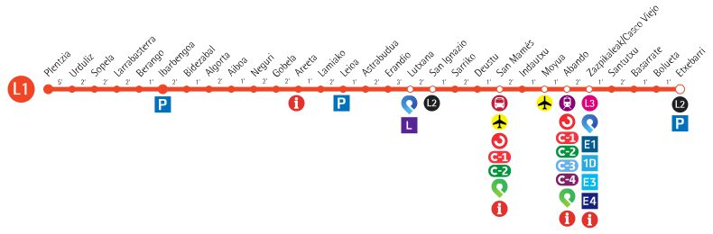
Español: Esquema Línea 1 Metro Bilbao Euskara: Bilboko metroaren 1. linearen eskema |
| Date | |
| Source | Own work |
| Author | Laukatu |
Licensing[edit]
I, the copyright holder of this work, hereby publish it under the following license:
This file is licensed under the Creative Commons Attribution-Share Alike 4.0 International license.
- You are free:
- to share – to copy, distribute and transmit the work
- to remix – to adapt the work
- Under the following conditions:
- attribution – You must give appropriate credit, provide a link to the license, and indicate if changes were made. You may do so in any reasonable manner, but not in any way that suggests the licensor endorses you or your use.
- share alike – If you remix, transform, or build upon the material, you must distribute your contributions under the same or compatible license as the original.
File history
Click on a date/time to view the file as it appeared at that time.
| Date/Time | Thumbnail | Dimensions | User | Comment | |
|---|---|---|---|---|---|
| current | 12:11, 5 December 2022 | 790 × 260 (192 KB) | Mabema1 (talk | contribs) | Actualizados los identificadores de Cercanías | |
| 10:07, 27 July 2020 | 790 × 260 (183 KB) | Enekorga (talk | contribs) | Ibarbengoa geltokia gehitu dut/He añadido la estación de Ibarbengoa | ||
| 21:06, 8 September 2019 | 790 × 260 (162 KB) | Laukatu (talk | contribs) | Eguneraketa, Zazpikaleetan E4 linearekin lotura gehitu eta Boluetako geltokian E4 linearekin lotura kendu. Bestelako zuzenketa txikiak eta aldaketa estetikoak. / Actualización, añadir conexión con línea E4 en Casco Viejo y eliminar conexión con línea E4 en Bolueta. Otras correcciones menores y cambios estéticos. | ||
| 20:55, 28 September 2018 | 512 × 179 (172 KB) | Laukatu (talk | contribs) | Zuzenketa, Zazpikaleetako geltokian ez dago loturarik Euskotrenen E4 linearekin. / Corrección, en la estación de Zazpikaleak no hay conexión con la líne a E4 de Euskotren. | ||
| 17:42, 17 December 2017 | 719 × 275 (347 KB) | Laukatu (talk | contribs) | Actualización a 2017/12/18 tras el cambio de nombre de las estaciones de Ibarbengoa, San Ignazio, Deustu y Santimami/San Mamés. | ||
| 12:13, 18 November 2017 | 719 × 275 (341 KB) | Laukatu (talk | contribs) | Reverted to version as of 16:26, 28 October 2017 (UTC) Actualización a 2017/11/18 tras la reapertura de la estación de Gobela. | ||
| 19:38, 13 November 2017 | 719 × 275 (342 KB) | Laukatu (talk | contribs) | Actualización a 2017/11/13 tras el cierre de la estación de Gobela. | ||
| 16:26, 28 October 2017 | 719 × 275 (341 KB) | Laukatu (talk | contribs) | Actualización a 2017/10/27 tras el cierre de la oficina de atención a la clientela de San Inazio. | ||
| 15:06, 30 September 2017 | 719 × 275 (343 KB) | Laukatu (talk | contribs) | Geltokien arteko iraupenak gehitzea. Añadir tiempos entre paradas. | ||
| 01:26, 23 June 2017 | 719 × 261 (312 KB) | Laukatu (talk | contribs) | Actualización de correspondencias tras cambios en línea E1 de Euskotren |
You cannot overwrite this file.
File usage on Commons
The following 51 pages use this file:
- Bilbao Metro
- User:Chumwa/OgreBot/Potential transport maps/2017 April 1-10
- User:Chumwa/OgreBot/Potential transport maps/2017 April 21-30
- User:Chumwa/OgreBot/Potential transport maps/2017 December 11-20
- User:Chumwa/OgreBot/Potential transport maps/2017 June 21-30
- User:Chumwa/OgreBot/Potential transport maps/2017 May 1-10
- User:Chumwa/OgreBot/Potential transport maps/2017 November 11-20
- User:Chumwa/OgreBot/Potential transport maps/2017 October 21-31
- User:Chumwa/OgreBot/Potential transport maps/2017 September 21-30
- User:Chumwa/OgreBot/Potential transport maps/2018 September 21-30
- User:Chumwa/OgreBot/Potential transport maps/2019 September 1-10
- User:Chumwa/OgreBot/Public transport information/2014 November 1-10
- User:Chumwa/OgreBot/Public transport information/2015 April 1-10
- User:Chumwa/OgreBot/Public transport information/2015 May 21-31
- User:Chumwa/OgreBot/Public transport information/2017 April 21-30
- User:Chumwa/OgreBot/Public transport information/2017 December 11-20
- User:Chumwa/OgreBot/Public transport information/2017 June 21-30
- User:Chumwa/OgreBot/Public transport information/2017 May 1-10
- User:Chumwa/OgreBot/Public transport information/2017 November 11-20
- User:Chumwa/OgreBot/Public transport information/2017 October 21-31
- User:Chumwa/OgreBot/Public transport information/2017 September 21-30
- User:Chumwa/OgreBot/Public transport information/2018 September 21-30
- User:Chumwa/OgreBot/Public transport information/2019 September 1-10
- User:Chumwa/OgreBot/Public transport information/2020 July 21-31
- User:Chumwa/OgreBot/Public transport information/2022 December 1-10
- User:Chumwa/OgreBot/Transport Maps/2014 November 1-10
- User:Chumwa/OgreBot/Transport Maps/2015 April 1-10
- User:Chumwa/OgreBot/Transport Maps/2015 May 21-31
- User:Chumwa/OgreBot/Transport Maps/2017 April 1-10
- User:Chumwa/OgreBot/Transport Maps/2017 April 21-30
- User:Chumwa/OgreBot/Transport Maps/2017 December 11-20
- User:Chumwa/OgreBot/Transport Maps/2017 June 21-30
- User:Chumwa/OgreBot/Transport Maps/2017 May 1-10
- User:Chumwa/OgreBot/Transport Maps/2017 November 11-20
- User:Chumwa/OgreBot/Transport Maps/2017 October 21-31
- User:Chumwa/OgreBot/Transport Maps/2017 September 21-30
- User:Chumwa/OgreBot/Transport Maps/2018 September 21-30
- User:Chumwa/OgreBot/Transport Maps/2019 September 1-10
- User:Chumwa/OgreBot/Transport Maps/2020 July 21-31
- User:Chumwa/OgreBot/Transport Maps/2022 December 1-10
- User:Chumwa/OgreBot/Travel and communication maps/2017 April 1-10
- User:Chumwa/OgreBot/Travel and communication maps/2017 April 21-30
- User:Chumwa/OgreBot/Travel and communication maps/2017 December 11-20
- User:Chumwa/OgreBot/Travel and communication maps/2017 June 21-30
- User:Chumwa/OgreBot/Travel and communication maps/2017 May 1-10
- User:Chumwa/OgreBot/Travel and communication maps/2017 November 11-20
- User:Chumwa/OgreBot/Travel and communication maps/2017 October 21-31
- User:Chumwa/OgreBot/Travel and communication maps/2017 September 21-30
- User:Chumwa/OgreBot/Travel and communication maps/2018 September 21-30
- User:Chumwa/OgreBot/Travel and communication maps/2019 September 1-10
- User:Liesel/Rail transport/2014 November 1-10
File usage on other wikis
The following other wikis use this file:
- Usage on cs.wikipedia.org
- Usage on en.wikipedia.org
- Usage on es.wikipedia.org
- Usage on eu.wikipedia.org
- Usage on fr.wikipedia.org
- Usage on it.wikipedia.org
- Usage on ja.wikipedia.org
- Usage on ru.wikipedia.org
- Usage on th.wikipedia.org
- Usage on uk.wikipedia.org
- Usage on uz.wikipedia.org
- Usage on www.wikidata.org