File:Mejit LANDSAT 2000.PNG
Jump to navigation
Jump to search

Size of this preview: 800 × 540 pixels. Other resolutions: 320 × 216 pixels | 640 × 432 pixels | 1,033 × 697 pixels.
Original file (1,033 × 697 pixels, file size: 1.35 MB, MIME type: image/png)
Captions
Captions
Add a one-line explanation of what this file represents
Summary
[edit]
| Description |
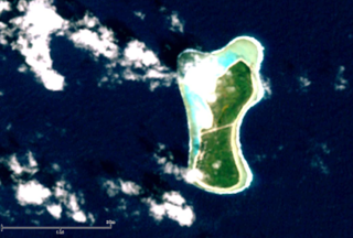
English: natural color satellite image of Mejit Island, Ratak Chain, Marshall Islands, Micronesia, Pacific Ocean |
| Date | |
| Source | NASA LANDSAT image, hosted by ESRI |
| Author | NASA |
Licensing
[edit]
| This file is in the public domain in the United States because it was solely created by NASA. NASA copyright policy states that "NASA material is not protected by copyright unless noted". (See Template:PD-USGov, NASA copyright policy page or JPL Image Use Policy.) | ||
 |
Warnings:
|
File history
Click on a date/time to view the file as it appeared at that time.
| Date/Time | Thumbnail | Dimensions | User | Comment | |
|---|---|---|---|---|---|
| current | 09:41, 2 January 2013 | | 1,033 × 697 (1.35 MB) | Ratzer (talk | contribs) | {{Information |Description ={{en|1=natural color satellite image of Mejit Island, Ratak Chain, Marshall Islands, Micronesia, Pacific Ocean}} |Source =NASA LANDSAT image, hosted by ESRI |Author =NASA |Date =2000 |Permission ... |
You cannot overwrite this file.
File usage on Commons
There are no pages that use this file.
File usage on other wikis
The following other wikis use this file:
- Usage on ast.wikipedia.org
- Usage on ca.wikipedia.org
- Usage on ceb.wikipedia.org
- Usage on de.wikipedia.org
- Usage on en.wikivoyage.org
- Usage on es.wikipedia.org
- Usage on fr.wikipedia.org
- Usage on mt.wikipedia.org
- Usage on pl.wikipedia.org
- Usage on sv.wikipedia.org
- Usage on ur.wikipedia.org
- Usage on www.wikidata.org