File:Megalópole Centro do México.png
Jump to navigation
Jump to search
Size of this preview: 800 × 526 pixels. Other resolutions: 320 × 210 pixels | 640 × 421 pixels | 1,024 × 673 pixels | 1,280 × 841 pixels | 2,282 × 1,500 pixels.
Original file (2,282 × 1,500 pixels, file size: 681 KB, MIME type: image/png)
Captions
Captions
Add a one-line explanation of what this file represents
Summary[edit]
| Description |
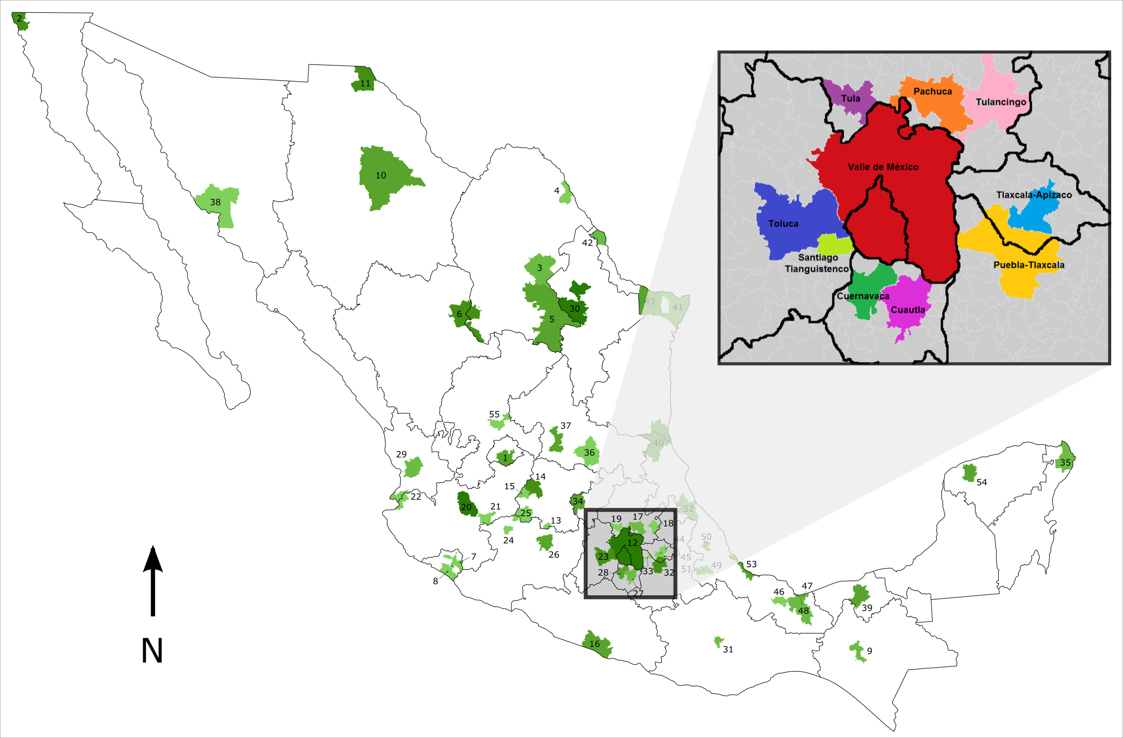
Português: Mapa de localização da Megalópole do México. |
| Date | (UTC) |
| Source |
This file was derived from: |
| Author |
| This is a retouched picture, which means that it has been digitally altered from its original version. The original can be viewed here: Metropolitan Areas of Mexico.svg:
|
Licensing[edit]
Luan, the copyright holder of this work, hereby publishes it under the following license:
This file is licensed under the Creative Commons Attribution-Share Alike 3.0 Brazil license.
Attribution: Luan
- You are free:
- to share – to copy, distribute and transmit the work
- to remix – to adapt the work
- Under the following conditions:
- attribution – You must give appropriate credit, provide a link to the license, and indicate if changes were made. You may do so in any reasonable manner, but not in any way that suggests the licensor endorses you or your use.
- share alike – If you remix, transform, or build upon the material, you must distribute your contributions under the same or compatible license as the original.


|
I'd greatly appreciate, that you attribute this media file to Wikimedia Commons, if used outside Wikipedia or Commons. For use in publications such as books, newspapers, blogs, websites, please insert here the following line:
Attribution: Luan
|
Original upload log[edit]
This image is a derivative work of the following images:
- File:Metropolitan Areas of Mexico.svg licensed with Cc-by-2.5, Cc-by-sa-3.0-migrated-with-disclaimers, GFDL-disclaimers, GFDL-with-disclaimers
- 2010-08-21T11:50:30Z File Upload Bot (Magnus Manske) 2282x1500 (859071 Bytes) {{BotMoveToCommons|en.wikipedia|year={{subst:CURRENTYEAR}}|month={{subst:CURRENTMONTHNAME}}|day={{subst:CURRENTDAY}}}} {{Information |Description={{en|This map gives the location of the 55 [[:en:Metropolitan Area|]]s identif
- File:Megapolis Mexico Nombres.png licensed with Cc-by-sa-4.0
Uploaded with derivativeFX
File history
Click on a date/time to view the file as it appeared at that time.
| Date/Time | Thumbnail | Dimensions | User | Comment | |
|---|---|---|---|---|---|
| current | 02:35, 7 May 2018 | | 2,282 × 1,500 (681 KB) | Luan (talk | contribs) | == {{int:filedesc}} == {{Information |Description={{pt|Mapa de localização da Megalópole do México.}} |Source={{Derived from|Metropolitan Areas of Mexico.svg|Megapolis Mexico Nombres.png|display=50}} |Date=2018-05-07 02:33 (UTC) |Author=* File:Metropolitan Areas of Mexico.svg: {{user at project|Rune.welsh|wikipedia|en}} * File:Megapolis Mexico Nombres.png: AntoFran * derivative work: [[User:{{s... |
You cannot overwrite this file.
File usage on Commons
The following 3 pages use this file:
File usage on other wikis
The following other wikis use this file:
- Usage on es.wikipedia.org
- Usage on eu.wikipedia.org
- Usage on gl.wikipedia.org
- Usage on pt.wikipedia.org
- Usage on www.wikidata.org